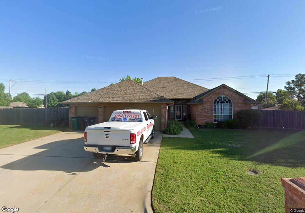
11869 SW 1st St Yukon, OK 73099
West Watch NeighborhoodEstimated Value: $273,000 - $312,269
4
Beds
2
Baths
2,482
Sq Ft
$118/Sq Ft
Est. Value
About This Home
This home is located at 11869 SW 1st St, Yukon, OK 73099 and is currently estimated at $293,567, approximately $118 per square foot. 11869 SW 1st St is a home located in Canadian County with nearby schools including Mustang Creek Elementary School, Meadow Brook Intermediate School, and Mustang Central Middle School.
Ownership History
Date
Name
Owned For
Owner Type
Purchase Details
Closed on
Dec 31, 2019
Sold by
Shepherd Mark A and Shepherd Mary Ann
Bought by
Horeb Properties Inc
Current Estimated Value
Purchase Details
Closed on
Feb 27, 2014
Sold by
Goss Lizabeth Ann
Bought by
Shepherd Mark A
Purchase Details
Closed on
Jul 2, 1997
Sold by
Edmonds,Betty & Jene W Trustee
Purchase Details
Closed on
May 23, 1997
Sold by
Steve Grissom Inc
Purchase Details
Closed on
Feb 17, 1997
Sold by
Willow Investors Llc
Purchase Details
Closed on
Jun 3, 1996
Sold by
Romart Inc
Purchase Details
Closed on
Oct 26, 1995
Sold by
Romart Inc
Create a Home Valuation Report for This Property
The Home Valuation Report is an in-depth analysis detailing your home's value as well as a comparison with similar homes in the area
Home Values in the Area
Average Home Value in this Area
Purchase History
| Date | Buyer | Sale Price | Title Company |
|---|---|---|---|
| Horeb Properties Inc | $183,000 | Chicago Title Oklahoma Co | |
| Shepherd Mark A | $131,000 | None Available | |
| -- | -- | -- | |
| -- | $120,000 | -- | |
| -- | $7,500 | -- | |
| -- | $88,500 | -- | |
| -- | -- | -- |
Source: Public Records
Tax History Compared to Growth
Tax History
| Year | Tax Paid | Tax Assessment Tax Assessment Total Assessment is a certain percentage of the fair market value that is determined by local assessors to be the total taxable value of land and additions on the property. | Land | Improvement |
|---|---|---|---|---|
| 2024 | $2,919 | $27,070 | $3,394 | $23,676 |
| 2023 | $2,919 | $25,781 | $3,136 | $22,645 |
| 2022 | $2,822 | $24,553 | $2,817 | $21,736 |
| 2021 | $2,678 | $23,384 | $2,160 | $21,224 |
| 2020 | $2,737 | $23,664 | $2,160 | $21,504 |
| 2019 | $2,483 | $22,489 | $2,160 | $20,329 |
| 2018 | $2,411 | $21,480 | $2,160 | $19,320 |
| 2017 | $2,410 | $21,738 | $2,160 | $19,578 |
| 2016 | $2,405 | $21,760 | $2,160 | $19,600 |
| 2015 | $2,310 | $23,713 | $2,160 | $21,553 |
| 2014 | $2,310 | $20,784 | $2,051 | $18,733 |
Source: Public Records
Map
Nearby Homes
- 311 Tumbleweed Rd
- 200 Pawnee Cir
- 418 Palo Verde Dr
- 624 Caladium Dr
- 11817 Hollyrock Dr
- 12177 Hollyrock Dr
- 708 Cactus Ct
- 12127 SW 4th St
- 309 Glen Dr
- 310 Glen Dr
- 705 Westview Dr
- 612 S Willowood Dr
- 1000 Redwood Creek Dr
- 1004 Redwood Creek Dr
- 1008 Redwood Creek Dr
- 1012 Redwood Creek Dr
- 1016 Redwood Creek Dr
- 108 N Eastgate Dr
- 1005 Redwood Creek Dr
- 1009 Redwood Creek Dr
- 11861 SW 1st St
- 201 Out West Trail
- 201 Out Trail W
- 11860 SW 1st St
- 11856 SW 1st St
- 205 Out West Trail
- 11857 SW 1st St
- 11852 SW 1st St
- 11904 Sagamore Dr
- 209 Out West Trail
- 11900 Sagamore Dr
- 11908 Sagamore Dr
- 213 Out West Trail
- 213 Out Trail W
- 11844 Sagamore Dr
- 11848 SW 1st St
- 204 Conestoga Dr
- 11869 SW 2nd St
- 11873 SW 2nd St
- 11912 Sagamore Dr