Estimated Value: $1,114,000 - $1,345,000
3
Beds
4
Baths
2,309
Sq Ft
$529/Sq Ft
Est. Value
About This Home
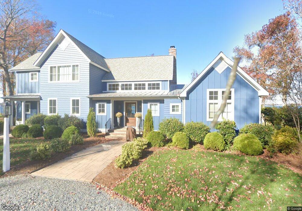
This home is located at 1188 Indiantown Rd, Weems, VA 22576 and is currently estimated at $1,220,513, approximately $528 per square foot. 1188 Indiantown Rd is a home located in Lancaster County with nearby schools including Lancaster Primary School, Lancaster Middle School, and Lancaster High School.
Ownership History
Date
Name
Owned For
Owner Type
Purchase Details
Closed on
Oct 27, 2015
Sold by
Rotondo Richard James and Rotondo Mary Ellen
Bought by
Osgood Thomas W and Osgood Lloyd
Current Estimated Value
Home Financials for this Owner
Home Financials are based on the most recent Mortgage that was taken out on this home.
Original Mortgage
$237,600
Outstanding Balance
$186,169
Interest Rate
3.92%
Mortgage Type
New Conventional
Estimated Equity
$1,034,344
Create a Home Valuation Report for This Property
The Home Valuation Report is an in-depth analysis detailing your home's value as well as a comparison with similar homes in the area
Home Values in the Area
Average Home Value in this Area
Purchase History
| Date | Buyer | Sale Price | Title Company |
|---|---|---|---|
| Osgood Thomas W | $297,000 | None Available |
Source: Public Records
Mortgage History
| Date | Status | Borrower | Loan Amount |
|---|---|---|---|
| Open | Osgood Thomas W | $237,600 |
Source: Public Records
Tax History Compared to Growth
Tax History
| Year | Tax Paid | Tax Assessment Tax Assessment Total Assessment is a certain percentage of the fair market value that is determined by local assessors to be the total taxable value of land and additions on the property. | Land | Improvement |
|---|---|---|---|---|
| 2025 | $5,840 | $1,061,800 | $314,000 | $747,800 |
| 2024 | $5,840 | $1,061,800 | $314,000 | $747,800 |
| 2023 | $4,826 | $766,100 | $299,000 | $467,100 |
| 2022 | $4,826 | $766,100 | $299,000 | $467,100 |
| 2021 | $4,826 | $766,100 | $299,000 | $467,100 |
| 2020 | $4,826 | $766,100 | $299,000 | $467,100 |
| 2019 | $4,826 | $766,100 | $299,000 | $467,100 |
| 2018 | $4,276 | $724,800 | $318,000 | $406,800 |
| 2017 | $3,054 | $517,700 | $318,000 | $199,700 |
| 2016 | -- | $334,000 | $314,000 | $20,000 |
| 2014 | -- | $0 | $0 | $0 |
| 2013 | -- | $0 | $0 | $0 |
Source: Public Records
Map
Nearby Homes
- 602 Cedar Pointe Dr
- 411 Cedar Pointe Dr
- 2012 Millenbeck Rd
- 1020 Queenstown Rd
- 90 Deep Harbor Ln
- 19 Wharton Grove Ln
- #27-35 Berkeley Forest Rd
- 72 James Ln
- 67 Lewis Ln
- Map 3324C Sunset Dr
- Lot 27_35a Taylor's Creek Rd
- 1678 Weems Rd
- 289 King Carter Ln
- 212 Gordon Dr
- 27-56A Peake Rd
- 27 56A Peake Rd
- 102B Beechwood Dr
- 1741 Taylors Creek Rd
- 145 Beechwood Dr
- TBD Cove Colony Rd
- 1226 Indiantown Rd
- 1214 Indiantown Rd
- 1164 Indiantown Rd
- 1268 Indiantown Rd
- 1100 Indiantown Rd
- 1290 Indiantown Rd
- 1020 Indiantown Rd
- 1314 Indiantown Rd
- 988 Indiantown Rd
- 1384 Indiantown Rd
- 924 Indiantown Rd
- 1413 Indiantown Rd
- 1421 Indiantown Rd
- 1432 Indiantown Rd
- 628 Cedar Pointe Dr
- 627 Cedar Pointe Dr
- 621 Cedar Pointe Dr
- 420 Benson Rd
- 617 Cedar Pointe Dr
- 0 Indiantown Rd Unit 1221211