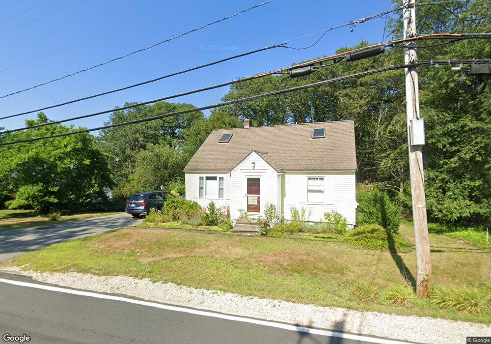
1188 State Rd Eliot, ME 03903
South Eliot NeighborhoodEstimated Value: $504,000 - $598,000
2
Beds
1
Bath
1,394
Sq Ft
$389/Sq Ft
Est. Value
About This Home
This home is located at 1188 State Rd, Eliot, ME 03903 and is currently estimated at $542,428, approximately $389 per square foot. 1188 State Rd is a home located in York County with nearby schools including Marshwood High School and Seacoast Waldorf School.
Ownership History
Date
Name
Owned For
Owner Type
Purchase Details
Closed on
Oct 14, 2021
Sold by
Thornton Eric and Thornton Laura
Bought by
Thornton Jacob and Thornton Jessica
Current Estimated Value
Purchase Details
Closed on
Aug 12, 2005
Sold by
Piscataqua Homes Llc
Bought by
Thornton Eric and Thornton Laura
Home Financials for this Owner
Home Financials are based on the most recent Mortgage that was taken out on this home.
Original Mortgage
$184,000
Interest Rate
6%
Mortgage Type
Adjustable Rate Mortgage/ARM
Purchase Details
Closed on
Mar 2, 2005
Sold by
Edward Jones T Co
Bought by
Piscataqua Homes Llc
Create a Home Valuation Report for This Property
The Home Valuation Report is an in-depth analysis detailing your home's value as well as a comparison with similar homes in the area
Home Values in the Area
Average Home Value in this Area
Purchase History
| Date | Buyer | Sale Price | Title Company |
|---|---|---|---|
| Thornton Jacob | -- | None Available | |
| Thornton Eric | -- | -- | |
| Piscataqua Homes Llc | -- | -- |
Source: Public Records
Mortgage History
| Date | Status | Borrower | Loan Amount |
|---|---|---|---|
| Previous Owner | Thornton Eric | $184,000 | |
| Previous Owner | Thornton Eric | $46,000 |
Source: Public Records
Tax History Compared to Growth
Tax History
| Year | Tax Paid | Tax Assessment Tax Assessment Total Assessment is a certain percentage of the fair market value that is determined by local assessors to be the total taxable value of land and additions on the property. | Land | Improvement |
|---|---|---|---|---|
| 2024 | $3,882 | $327,600 | $138,000 | $189,600 |
| 2023 | $3,733 | $304,700 | $131,100 | $173,600 |
| 2022 | $3,591 | $296,800 | $131,100 | $165,700 |
| 2021 | $2,725 | $225,600 | $99,800 | $125,800 |
| 2020 | $3,116 | $212,000 | $95,000 | $117,000 |
| 2019 | $0 | $212,000 | $95,000 | $117,000 |
| 2018 | $3,116 | $212,000 | $95,000 | $117,000 |
| 2017 | $0 | $212,000 | $95,000 | $117,000 |
| 2016 | $2,979 | $212,000 | $95,000 | $117,000 |
| 2015 | $2,968 | $212,000 | $95,000 | $117,000 |
| 2014 | $2,829 | $205,000 | $95,000 | $110,000 |
| 2013 | $2,700 | $205,000 | $95,000 | $110,000 |
Source: Public Records
Map
Nearby Homes
- 850 Main St
- 956 Main St
- 8 Caslyn Dr
- 35 Leach Rd
- 0 Franks Fort Island Unit 1631886
- 493 Main St
- 7 Fernald Rd
- 46 Littlebrook Ln
- 5 Spinney Way Unit 9
- 124 Spinnaker Way
- 19 Shearwater Dr Unit 1903
- 15 Shearwater Dr Unit 1902
- 3 Shearwater Dr Unit 1900
- 37 Shearwater Dr Unit 1906
- 10 Shipwright Way
- 201 Kearsarge Way
- 25 Mangrove St
- 51 Granite St
- 14 Birch St
- 1338 Woodbury Ave Unit 10