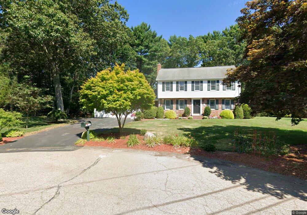
119 Donald Tennant Cir North Attleboro, MA 02760
North Attleboro NeighborhoodEstimated Value: $710,500 - $755,000
4
Beds
3
Baths
2,086
Sq Ft
$352/Sq Ft
Est. Value
About This Home
This home is located at 119 Donald Tennant Cir, North Attleboro, MA 02760 and is currently estimated at $733,375, approximately $351 per square foot. 119 Donald Tennant Cir is a home located in Bristol County with nearby schools including North Attleboro High School, Cadence Academy Preschool - North Attleborough, and Bishop Feehan High School.
Ownership History
Date
Name
Owned For
Owner Type
Purchase Details
Closed on
Jun 15, 1987
Sold by
Cabral Steven M
Bought by
Burke William G
Current Estimated Value
Home Financials for this Owner
Home Financials are based on the most recent Mortgage that was taken out on this home.
Original Mortgage
$65,000
Interest Rate
10.47%
Mortgage Type
Purchase Money Mortgage
Create a Home Valuation Report for This Property
The Home Valuation Report is an in-depth analysis detailing your home's value as well as a comparison with similar homes in the area
Home Values in the Area
Average Home Value in this Area
Purchase History
| Date | Buyer | Sale Price | Title Company |
|---|---|---|---|
| Burke William G | $186,000 | -- |
Source: Public Records
Mortgage History
| Date | Status | Borrower | Loan Amount |
|---|---|---|---|
| Closed | Burke William G | $73,000 | |
| Closed | Burke William G | $65,000 |
Source: Public Records
Tax History Compared to Growth
Tax History
| Year | Tax Paid | Tax Assessment Tax Assessment Total Assessment is a certain percentage of the fair market value that is determined by local assessors to be the total taxable value of land and additions on the property. | Land | Improvement |
|---|---|---|---|---|
| 2025 | $6,933 | $588,000 | $145,600 | $442,400 |
| 2024 | $6,974 | $604,300 | $145,600 | $458,700 |
| 2023 | $6,478 | $506,500 | $145,600 | $360,900 |
| 2022 | $6,126 | $439,800 | $145,600 | $294,200 |
| 2021 | $5,816 | $407,600 | $145,600 | $262,000 |
| 2020 | $5,741 | $400,100 | $145,600 | $254,500 |
| 2019 | $5,555 | $390,100 | $132,400 | $257,700 |
| 2018 | $5,034 | $374,900 | $132,400 | $242,500 |
| 2017 | $4,956 | $374,900 | $132,400 | $242,500 |
| 2016 | $4,755 | $359,700 | $147,200 | $212,500 |
| 2015 | $4,561 | $347,100 | $147,200 | $199,900 |
| 2014 | $4,356 | $329,000 | $129,100 | $199,900 |
Source: Public Records
Map
Nearby Homes
- 196 Donald Tennant Cir
- 11 Landry Ave
- 115 Westfield Dr
- 57 Vine St
- 11 Buckthorn Ln
- 255 Mckeon Dr
- Lot 2 Jeffrey Dr
- Lot 5 Jeffrey Dr
- 116 George St
- 5 Old Wood Rd
- 150 Gilbert St
- 12 Houde St
- 24 Maverick Dr
- 40 Natalie Dr
- 20 Sperry Ln
- 21 Shady Ln
- 835 Mt Hope St Unit 39
- 28 Messenger St
- 9 Sunnyside Dr Unit 9
- 158 Ivy St
- 109 Donald Tennant Cir
- 125 Donald Tennant Cir
- 98 Donald Tennant Cir
- 104 Donald Tennant Cir
- 103 Donald Tennant Cir
- 90 Donald Tennant Cir
- 91 Donald Tennant Cir
- 84 Donald Tennant Cir
- 35 Indian Trail
- 85 Donald Tennant Cir
- 32 Indian Trail
- 70 Donald Tennant Cir
- 73 Donald Tennant Cir
- 66 Donald Tennant Cir
- 53 Donald Tennant Cir
- 56 Donald Tennant Cir
- 158 Bungay Rd
- 11 Indian Trail
- 21 Indian Trail
- 48 Donald Tennant Cir