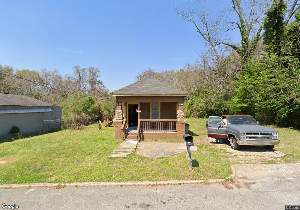
119 Foch St Lagrange, GA 30241
Estimated Value: $57,590 - $95,000
2
Beds
1
Bath
800
Sq Ft
$95/Sq Ft
Est. Value
About This Home
This home is located at 119 Foch St, Lagrange, GA 30241 and is currently estimated at $75,898, approximately $94 per square foot. 119 Foch St is a home located in Troup County with nearby schools including Franklin Forest Elementary School, Hollis Hand Elementary School, and Ethel W. Kight Elementary School.
Ownership History
Date
Name
Owned For
Owner Type
Purchase Details
Closed on
Jun 30, 2004
Sold by
Katrina Allen
Bought by
Bransdon P Perrin
Current Estimated Value
Purchase Details
Closed on
Jun 2, 2000
Sold by
Mattie Dunson
Bought by
Katrina Allen
Purchase Details
Closed on
Nov 17, 1978
Sold by
Mary Nell Oliver
Bought by
Mattie Dunson
Purchase Details
Closed on
Jan 1, 1939
Bought by
Mary Nell Oliver
Create a Home Valuation Report for This Property
The Home Valuation Report is an in-depth analysis detailing your home's value as well as a comparison with similar homes in the area
Home Values in the Area
Average Home Value in this Area
Purchase History
| Date | Buyer | Sale Price | Title Company |
|---|---|---|---|
| Bransdon P Perrin | $5,600 | -- | |
| Katrina Allen | -- | -- | |
| Mattie Dunson | -- | -- | |
| Mary Nell Oliver | -- | -- |
Source: Public Records
Tax History Compared to Growth
Tax History
| Year | Tax Paid | Tax Assessment Tax Assessment Total Assessment is a certain percentage of the fair market value that is determined by local assessors to be the total taxable value of land and additions on the property. | Land | Improvement |
|---|---|---|---|---|
| 2024 | $327 | $12,000 | $1,440 | $10,560 |
| 2023 | $249 | $9,120 | $1,440 | $7,680 |
| 2022 | $237 | $8,480 | $1,440 | $7,040 |
| 2021 | $214 | $7,080 | $1,440 | $5,640 |
| 2020 | $214 | $7,080 | $1,440 | $5,640 |
| 2019 | $183 | $6,060 | $1,500 | $4,560 |
| 2018 | $183 | $6,060 | $1,500 | $4,560 |
| 2017 | $183 | $6,060 | $1,500 | $4,560 |
| 2016 | $183 | $6,062 | $1,500 | $4,562 |
| 2015 | $186 | $6,141 | $1,456 | $4,685 |
| 2014 | $178 | $5,894 | $1,456 | $4,438 |
| 2013 | -- | $6,195 | $1,456 | $4,739 |
Source: Public Records
Map
Nearby Homes
- 131 Foch St
- 600 S Harlem Cir
- 606 S Harlem Cir
- 608 S Harlem Cir
- 616 S Harlem Cir
- 618 S Harlem Cir
- 706 N Harlem Cir
- 600,606,608,616 S Harlem
- 121 de Groat St
- 621 Arthur St
- 519 Greenville St
- 301 E Bacon St
- 902 Georgia Ave
- 906 Georgia Ave
- 801 Hines St
- 109 Dogwood Dr
- 803 1/2 Hines St
- 0 Ridley Ave Unit 10550104
- 609 Ridley Ave
- 707 Ridley Ave
- 117 1/2 Foch St
- 123 Foch St
- 117 Foch St
- 127 Foch St
- 122 Foch St
- 120 Foch St
- 128 Foch St
- 602 S Harlem Cir
- 604 S Harlem Cir
- 132 Foch St
- 402 Horace King St
- 610 S Harlem Cir
- 100 Foch St
- 0 S Harlem Cir
- S S Harlem Cir Unit 10
- 501 Horace King St
- 612 S Harlem Cir
- 502 Horace King St
- 541 E Bacon St
- 110 Foch St