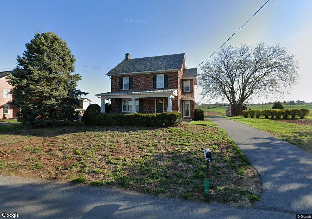
119 Hurst Rd Ephrata, PA 17522
Estimated Value: $350,104 - $517,000
4
Beds
2
Baths
1,710
Sq Ft
$239/Sq Ft
Est. Value
About This Home
This home is located at 119 Hurst Rd, Ephrata, PA 17522 and is currently estimated at $409,526, approximately $239 per square foot. 119 Hurst Rd is a home located in Lancaster County with nearby schools including Garden Spot Middle School, Garden Spot Senior High School, and Hinkletown Mennonite School.
Ownership History
Date
Name
Owned For
Owner Type
Purchase Details
Closed on
Nov 21, 2011
Sold by
Burkholder Glenn F and Burkholder Lori A
Bought by
Fox Annetta N and Fox Ida N
Current Estimated Value
Purchase Details
Closed on
Dec 3, 1998
Sold by
Burkholder Glenn F and Burkholder Lori A
Bought by
Burkholder Glenn F and Burkholder Lori A
Home Financials for this Owner
Home Financials are based on the most recent Mortgage that was taken out on this home.
Original Mortgage
$104,000
Interest Rate
6.8%
Create a Home Valuation Report for This Property
The Home Valuation Report is an in-depth analysis detailing your home's value as well as a comparison with similar homes in the area
Home Values in the Area
Average Home Value in this Area
Purchase History
| Date | Buyer | Sale Price | Title Company |
|---|---|---|---|
| Fox Annetta N | $251,500 | None Available | |
| Burkholder Glenn F | -- | -- |
Source: Public Records
Mortgage History
| Date | Status | Borrower | Loan Amount |
|---|---|---|---|
| Previous Owner | Burkholder Glenn F | $104,000 |
Source: Public Records
Tax History Compared to Growth
Tax History
| Year | Tax Paid | Tax Assessment Tax Assessment Total Assessment is a certain percentage of the fair market value that is determined by local assessors to be the total taxable value of land and additions on the property. | Land | Improvement |
|---|---|---|---|---|
| 2025 | $3,413 | $198,600 | $56,400 | $142,200 |
| 2024 | $3,413 | $198,600 | $56,400 | $142,200 |
| 2023 | $3,362 | $198,600 | $56,400 | $142,200 |
| 2022 | $3,324 | $198,600 | $56,400 | $142,200 |
| 2021 | $3,269 | $198,600 | $56,400 | $142,200 |
| 2020 | $3,269 | $198,600 | $56,400 | $142,200 |
| 2019 | $3,232 | $198,600 | $56,400 | $142,200 |
| 2018 | $4,791 | $198,600 | $56,400 | $142,200 |
| 2017 | $2,445 | $122,100 | $24,800 | $97,300 |
| 2016 | $2,445 | $122,100 | $24,800 | $97,300 |
| 2015 | $609 | $122,100 | $24,800 | $97,300 |
| 2014 | $1,695 | $122,100 | $24,800 | $97,300 |
Source: Public Records
Map
Nearby Homes
- 575 Red Run Rd
- 61 Gentle Dr
- 232 New St
- 200 E Main St
- 205 E Main St
- 420 Linden St
- 412 Linden St
- 133 Millstone Dr
- 111 Oatfield Dr
- 3 Whitetail Dr
- 322 Wissler Rd
- 553 Ridge Ave
- 20 N Kinzer Ave
- 1258 Main St
- 220 Sycamore Ln
- 148 E Broad St
- 144 W Conestoga St
- 41 Ashlea Village
- 158 Valley View Dr
- 210 Musser Rd
- 121 Hurst Rd
- 114 Hurst Rd
- 123 Hurst Rd
- 127 Hurst Rd
- 1088 Martindale Rd
- 132 Hurst Rd
- 133 Hurst Rd
- 1071 Martindale Rd
- 1052 Martindale Rd
- 1061 Martindale Rd
- 1051 Martindale Rd
- 1047 Martindale Rd
- 1041 Martindale Rd
- 135 Hurst Rd
- 1032 Martindale Rd
- 545 Gristmill Rd
- 1037 Martindale Rd
- 1028 Martindale Rd
- 1081 Martindale Rd
- 1095 Martindale Rd