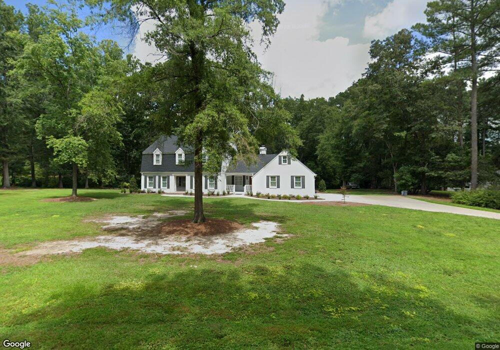
119 Jeffress Dr Louisburg, NC 27549
Estimated Value: $445,572 - $561,000
4
Beds
5
Baths
3,532
Sq Ft
$141/Sq Ft
Est. Value
About This Home
This home is located at 119 Jeffress Dr, Louisburg, NC 27549 and is currently estimated at $497,643, approximately $140 per square foot. 119 Jeffress Dr is a home located in Franklin County with nearby schools including Louisburg Elementary School, Terrell Lane Middle School, and Louisburg High School.
Ownership History
Date
Name
Owned For
Owner Type
Purchase Details
Closed on
Mar 2, 2018
Sold by
Beam Barbara A and Beam Barbara A
Bought by
Rushing Reginald A and Rushing Sandra S
Current Estimated Value
Home Financials for this Owner
Home Financials are based on the most recent Mortgage that was taken out on this home.
Original Mortgage
$120,000
Outstanding Balance
$66,475
Interest Rate
3.49%
Mortgage Type
New Conventional
Estimated Equity
$431,168
Create a Home Valuation Report for This Property
The Home Valuation Report is an in-depth analysis detailing your home's value as well as a comparison with similar homes in the area
Home Values in the Area
Average Home Value in this Area
Purchase History
| Date | Buyer | Sale Price | Title Company |
|---|---|---|---|
| Rushing Reginald A | $125,000 | None Available |
Source: Public Records
Mortgage History
| Date | Status | Borrower | Loan Amount |
|---|---|---|---|
| Open | Rushing Reginald A | $120,000 |
Source: Public Records
Tax History Compared to Growth
Tax History
| Year | Tax Paid | Tax Assessment Tax Assessment Total Assessment is a certain percentage of the fair market value that is determined by local assessors to be the total taxable value of land and additions on the property. | Land | Improvement |
|---|---|---|---|---|
| 2025 | $4,840 | $470,689 | $51,379 | $419,310 |
| 2024 | $4,840 | $470,689 | $51,379 | $419,310 |
| 2023 | $4,701 | $357,290 | $42,660 | $314,630 |
| 2022 | $4,513 | $357,290 | $42,660 | $314,630 |
| 2021 | $4,548 | $357,290 | $42,660 | $314,630 |
| 2020 | $2,586 | $199,110 | $42,660 | $156,450 |
| 2019 | $2,973 | $230,890 | $42,660 | $188,230 |
| 2018 | $2,750 | $213,400 | $42,660 | $170,740 |
| 2017 | $2,142 | $149,110 | $38,780 | $110,330 |
| 2016 | $2,227 | $149,110 | $38,780 | $110,330 |
| 2015 | $2,257 | $149,110 | $38,780 | $110,330 |
| 2014 | $2,154 | $149,110 | $38,780 | $110,330 |
Source: Public Records
Map
Nearby Homes
- 7.69 Acres N Carolina 561
- 23.20 Acre N Carolina 561
- 10.26 Acre N Carolina 561
- 0-0 Halifax Rd
- 109 Drew St
- 126 Person St
- 612 N Main St
- 101 Briarwood Ct
- 125 Davis St
- 604 N Main St
- 401 N Main St
- 191 Nc 56 Hwy E
- 321 W Noble St
- 301 W College St
- 313 W Noble St
- 305 N Elm St
- 205 Williamson St
- 414 W Noble St
- 615 Woodland Trail
- 311 Nc 56 Hwy E
- 117 Jeffress Dr
- 123 Jeffress Dr
- 108 Jeffress Dr
- 124 Jeffress Dr
- 106 Jeffress Dr
- 120 Carol Cir
- 115 Jeffress Dr
- 112 Stratford Dr
- 105 Carol Cir
- 125 Jeffress Dr
- 126 Jeffress Dr
- 116 Carol Cir
- 306 Lumpkin Blvd
- 304 Lumpkin Blvd
- 302 Lumpkin Blvd
- 402 Lumpkin Blvd
- 124 Stratford Dr
- 212 Lumpkin Blvd
- 103 Carol Cir
- 103 Carol Cir