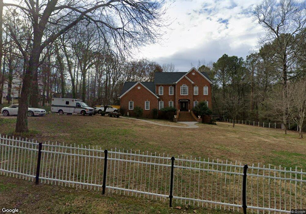
119 Kent Ln Calhoun, GA 30701
Estimated Value: $485,000 - $515,000
4
Beds
4
Baths
4,038
Sq Ft
$123/Sq Ft
Est. Value
About This Home
This home is located at 119 Kent Ln, Calhoun, GA 30701 and is currently estimated at $494,941, approximately $122 per square foot. 119 Kent Ln is a home located in Gordon County with nearby schools including Red Bud Elementary School.
Ownership History
Date
Name
Owned For
Owner Type
Purchase Details
Closed on
Jul 13, 2020
Sold by
Talley Charles A
Bought by
Xavier Manson
Current Estimated Value
Home Financials for this Owner
Home Financials are based on the most recent Mortgage that was taken out on this home.
Original Mortgage
$270,750
Outstanding Balance
$240,529
Interest Rate
3.2%
Mortgage Type
New Conventional
Estimated Equity
$254,412
Purchase Details
Closed on
Jul 28, 2011
Sold by
Guardado Kitsia P
Bought by
Talley Charles A
Home Financials for this Owner
Home Financials are based on the most recent Mortgage that was taken out on this home.
Original Mortgage
$210,000
Interest Rate
4.53%
Mortgage Type
VA
Purchase Details
Closed on
Jul 14, 2006
Sold by
Miller Randy W
Bought by
Guardado Kitsia P
Home Financials for this Owner
Home Financials are based on the most recent Mortgage that was taken out on this home.
Original Mortgage
$328,400
Interest Rate
6.6%
Mortgage Type
New Conventional
Purchase Details
Closed on
Jan 3, 1996
Bought by
Miller Randy W
Create a Home Valuation Report for This Property
The Home Valuation Report is an in-depth analysis detailing your home's value as well as a comparison with similar homes in the area
Home Values in the Area
Average Home Value in this Area
Purchase History
| Date | Buyer | Sale Price | Title Company |
|---|---|---|---|
| Xavier Manson | $285,000 | -- | |
| Talley Charles A | $210,000 | -- | |
| Guardado Kitsia P | $364,900 | -- | |
| Miller Randy W | $20,500 | -- |
Source: Public Records
Mortgage History
| Date | Status | Borrower | Loan Amount |
|---|---|---|---|
| Open | Xavier Manson | $270,750 | |
| Previous Owner | Talley Charles A | $210,000 | |
| Previous Owner | Guardado Kitsia P | $328,400 |
Source: Public Records
Tax History Compared to Growth
Tax History
| Year | Tax Paid | Tax Assessment Tax Assessment Total Assessment is a certain percentage of the fair market value that is determined by local assessors to be the total taxable value of land and additions on the property. | Land | Improvement |
|---|---|---|---|---|
| 2024 | $4,396 | $156,360 | $5,600 | $150,760 |
| 2023 | $4,090 | $145,480 | $5,600 | $139,880 |
| 2022 | $1,285 | $135,040 | $5,600 | $129,440 |
| 2021 | $3,306 | $111,040 | $5,600 | $105,440 |
| 2020 | $3,350 | $112,280 | $5,600 | $106,680 |
| 2019 | $3,345 | $112,280 | $5,600 | $106,680 |
| 2018 | $972 | $102,920 | $5,600 | $97,320 |
| 2017 | $935 | $97,080 | $5,600 | $91,480 |
| 2016 | $937 | $97,080 | $5,600 | $91,480 |
| 2015 | $929 | $95,120 | $5,600 | $89,520 |
| 2014 | $886 | $91,930 | $5,600 | $86,330 |
Source: Public Records
Map
Nearby Homes
- 129 Derby Ln
- 130 Cambridge Ct
- 140 Cambridge Ct
- 127 Windsor Dr
- 326 Curtis Pkwy NE
- 114 Lindsey Ct NE
- 133 Kentucky Dr NE
- 112 Willowbrook Dr SE
- 202 Montclair Dr
- 195 Dogwood Dr SE
- 2148 Red Bud Rd NE
- 209 Willowbrook Dr SE
- 220 Lenox Rd SE
- 121 Hunt Dr
- 62 Professional Place Unit 30
- 107 Savoy Place SE
- 218 Newtown Rd NE
- 103 Mims Dr
- 0 Redwood St Unit 7563377