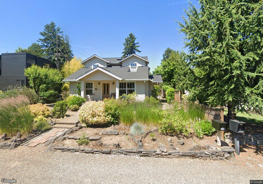
119 Ladd St Lake Oswego, OR 97034
Foothills NeighborhoodEstimated Value: $807,000 - $1,386,167
2
Beds
1
Bath
800
Sq Ft
$1,515/Sq Ft
Est. Value
About This Home
This home is located at 119 Ladd St, Lake Oswego, OR 97034 and is currently estimated at $1,211,792, approximately $1,514 per square foot. 119 Ladd St is a home located in Clackamas County with nearby schools including Hallinan Elementary School, Lakeridge Middle School, and Lakeridge High School.
Ownership History
Date
Name
Owned For
Owner Type
Purchase Details
Closed on
Jun 10, 2025
Sold by
Sterling Philip
Bought by
Philip Richard Sterling Living Trust
Current Estimated Value
Purchase Details
Closed on
Sep 8, 2006
Sold by
Sterling Philip R
Bought by
Sterling Philip and Sterling Yumiko
Purchase Details
Closed on
Oct 28, 1999
Sold by
Thornburgh Jeffrey W and Thornburgh Heidi Anne
Bought by
Sterling Philip
Home Financials for this Owner
Home Financials are based on the most recent Mortgage that was taken out on this home.
Original Mortgage
$132,800
Interest Rate
7.82%
Purchase Details
Closed on
Apr 20, 1995
Sold by
Montgomery Robert and Montgomery Iva
Bought by
Thornburgh Jeffrey W and Thornburgh Heidi Anne
Home Financials for this Owner
Home Financials are based on the most recent Mortgage that was taken out on this home.
Original Mortgage
$108,900
Interest Rate
8.77%
Create a Home Valuation Report for This Property
The Home Valuation Report is an in-depth analysis detailing your home's value as well as a comparison with similar homes in the area
Home Values in the Area
Average Home Value in this Area
Purchase History
| Date | Buyer | Sale Price | Title Company |
|---|---|---|---|
| Philip Richard Sterling Living Trust | -- | None Listed On Document | |
| Sterling Philip | -- | None Available | |
| Sterling Philip | $166,000 | Fidelity National Title Co | |
| Thornburgh Jeffrey W | $121,000 | Chicago Title Insurance Co |
Source: Public Records
Mortgage History
| Date | Status | Borrower | Loan Amount |
|---|---|---|---|
| Previous Owner | Sterling Philip | $132,800 | |
| Previous Owner | Thornburgh Jeffrey W | $108,900 |
Source: Public Records
Tax History Compared to Growth
Tax History
| Year | Tax Paid | Tax Assessment Tax Assessment Total Assessment is a certain percentage of the fair market value that is determined by local assessors to be the total taxable value of land and additions on the property. | Land | Improvement |
|---|---|---|---|---|
| 2025 | $10,324 | $538,762 | -- | -- |
| 2024 | $10,049 | $523,070 | -- | -- |
| 2023 | $10,049 | $507,835 | $0 | $0 |
| 2022 | $9,464 | $493,044 | $0 | $0 |
| 2021 | $8,740 | $478,684 | $0 | $0 |
| 2020 | $8,521 | $464,742 | $0 | $0 |
| 2019 | $8,311 | $451,206 | $0 | $0 |
| 2018 | $7,903 | $438,064 | $0 | $0 |
| 2017 | $7,626 | $425,305 | $0 | $0 |
| 2016 | $6,941 | $412,917 | $0 | $0 |
| 2015 | $6,706 | $400,890 | $0 | $0 |
| 2014 | $6,620 | $389,214 | $0 | $0 |
Source: Public Records
Map
Nearby Homes
- 420 S State St
- 668 Mcvey Ave Unit 83
- 16200 Pacific Hwy Unit 4
- 990 Lund St
- 408 Ridgeway Rd
- 600 Maple St
- 200 Burnham Rd Unit 200
- 161 3rd St
- 589 Ridgeway Rd
- 16081 Pearcy St
- 719 SW Maple St
- 15323 SE Fairoaks Ave
- 116 6th St
- 14411 SE Wagner Ln
- 852 Northshore Rd
- 2147 Glenmorrie Ln
- 382 5th St
- 527 2nd St Unit 101
- 1206 Cedar St
- 919 Westpoint Rd