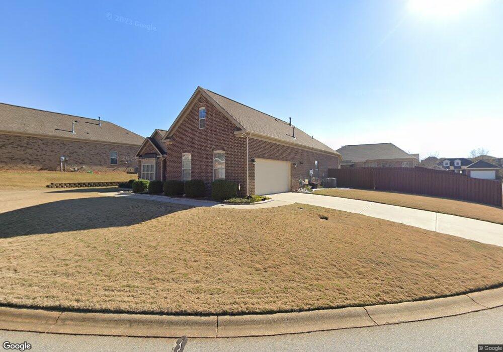
119 Macintyre St Simpsonville, SC 29680
Estimated Value: $435,922 - $478,000
3
Beds
2
Baths
2,863
Sq Ft
$161/Sq Ft
Est. Value
About This Home
This home is located at 119 Macintyre St, Simpsonville, SC 29680 and is currently estimated at $460,231, approximately $160 per square foot. 119 Macintyre St is a home with nearby schools including Fork Shoals School, Woodmont Middle School, and Woodmont High School.
Ownership History
Date
Name
Owned For
Owner Type
Purchase Details
Closed on
Apr 30, 2013
Sold by
D R Horton Inc
Bought by
Gossett Daniel R and Gossett Beverly M
Current Estimated Value
Home Financials for this Owner
Home Financials are based on the most recent Mortgage that was taken out on this home.
Original Mortgage
$248,418
Outstanding Balance
$176,898
Interest Rate
3.59%
Mortgage Type
VA
Estimated Equity
$283,333
Purchase Details
Closed on
Feb 9, 2006
Sold by
Windsor/Aughtry Co Inc
Bought by
D R Horton Inc
Create a Home Valuation Report for This Property
The Home Valuation Report is an in-depth analysis detailing your home's value as well as a comparison with similar homes in the area
Home Values in the Area
Average Home Value in this Area
Purchase History
| Date | Buyer | Sale Price | Title Company |
|---|---|---|---|
| Gossett Daniel R | $240,483 | -- | |
| D R Horton Inc | $650,000 | None Available |
Source: Public Records
Mortgage History
| Date | Status | Borrower | Loan Amount |
|---|---|---|---|
| Open | Gossett Daniel R | $248,418 |
Source: Public Records
Tax History Compared to Growth
Tax History
| Year | Tax Paid | Tax Assessment Tax Assessment Total Assessment is a certain percentage of the fair market value that is determined by local assessors to be the total taxable value of land and additions on the property. | Land | Improvement |
|---|---|---|---|---|
| 2024 | $1,481 | $10,990 | $1,560 | $9,430 |
| 2023 | $1,481 | $10,990 | $1,560 | $9,430 |
| 2022 | $1,444 | $10,990 | $1,560 | $9,430 |
| 2021 | $1,421 | $10,990 | $1,560 | $9,430 |
| 2020 | $1,274 | $9,560 | $1,360 | $8,200 |
| 2019 | $1,237 | $9,560 | $1,360 | $8,200 |
| 2018 | $1,659 | $9,560 | $1,360 | $8,200 |
| 2017 | $1,661 | $9,560 | $1,360 | $8,200 |
| 2016 | $1,603 | $238,930 | $34,000 | $204,930 |
| 2015 | $1,594 | $238,930 | $34,000 | $204,930 |
| 2014 | $1,502 | $226,810 | $34,000 | $192,810 |
Source: Public Records
Map
Nearby Homes
- 109 Macintyre St
- 1 Indian Laurel Ct
- 210 Bank Swallow Way
- 23 Shefleys Rd
- 315 Hunslet Way
- 406 Windwood St
- 116 Eben Way Ln
- 112 Terrapin Cross Way
- 230 Deer Spring Ln
- 101 Hunslet Way
- 14 Foxmoor Ct
- 311 Lindstrom Ct
- 613 Whitemarsh Ave
- 212 Terrapin Cross Way
- 18 Ebenway Ln
- 214 Terrapin Cross Way
- 8 Atchison Way
- 109 Deer Spring Ln
- 5 Teakwood Cove
- 633 Neely Farm Dr
- 115 Macintyre St
- 16 Brentmoor Place
- 14 Brentmoor Place
- 113 Macintyre St
- 12 Brentmoor Place
- 120 Macintyre St
- 118 Macintyre St
- 122 Macintyre St
- 116 Macintyre St
- 100 Brentmoor Place
- 111 Macintyre St
- 114 Macintyre St
- 10 Brentmoor Place
- 112 Macintyre St
- 102 Brentmoor Place
- 8 Brentmoor Place
- 19 Brentmoor Place
- 17 Brentmoor Place
- 21 Brentmoor Place
- 110 Macintyre St