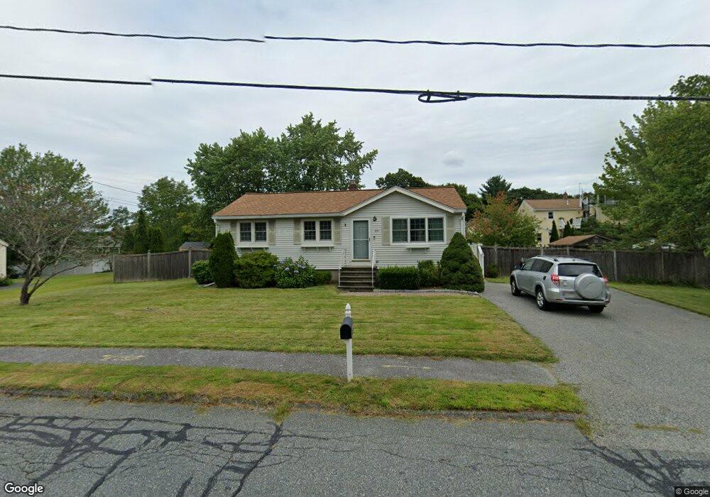
119 Main Blvd Shrewsbury, MA 01545
Estimated Value: $497,000 - $629,000
3
Beds
1
Bath
960
Sq Ft
$569/Sq Ft
Est. Value
About This Home
This home is located at 119 Main Blvd, Shrewsbury, MA 01545 and is currently estimated at $545,806, approximately $568 per square foot. 119 Main Blvd is a home located in Worcester County with nearby schools including Floral Street School, Sherwood Middle School, and Oak Middle School.
Ownership History
Date
Name
Owned For
Owner Type
Purchase Details
Closed on
Oct 16, 2009
Sold by
Katz Shane W and Katz Cheryl B
Bought by
Smith Anne Marie
Current Estimated Value
Home Financials for this Owner
Home Financials are based on the most recent Mortgage that was taken out on this home.
Original Mortgage
$283,000
Outstanding Balance
$183,857
Interest Rate
5.14%
Mortgage Type
Purchase Money Mortgage
Estimated Equity
$361,949
Purchase Details
Closed on
Feb 22, 2002
Sold by
Carifio Michael G and Carifio Melissa R
Bought by
Katz Shane W and Katz Cheryl B
Purchase Details
Closed on
Nov 2, 1987
Sold by
Schradieck Peter H
Bought by
Carifio Michael G
Create a Home Valuation Report for This Property
The Home Valuation Report is an in-depth analysis detailing your home's value as well as a comparison with similar homes in the area
Home Values in the Area
Average Home Value in this Area
Purchase History
| Date | Buyer | Sale Price | Title Company |
|---|---|---|---|
| Smith Anne Marie | $283,000 | -- | |
| Smith Anne Marie | $283,000 | -- | |
| Smith Anne Marie | $283,000 | -- | |
| Katz Shane W | $215,000 | -- | |
| Katz Shane W | $215,000 | -- | |
| Carifio Michael G | $142,000 | -- |
Source: Public Records
Mortgage History
| Date | Status | Borrower | Loan Amount |
|---|---|---|---|
| Open | Smith Anne Marie | $283,000 | |
| Closed | Smith Anne Marie | $283,000 | |
| Previous Owner | Carifio Michael G | $192,000 |
Source: Public Records
Tax History Compared to Growth
Tax History
| Year | Tax Paid | Tax Assessment Tax Assessment Total Assessment is a certain percentage of the fair market value that is determined by local assessors to be the total taxable value of land and additions on the property. | Land | Improvement |
|---|---|---|---|---|
| 2025 | $53 | $442,600 | $254,600 | $188,000 |
| 2024 | $4,750 | $383,700 | $242,500 | $141,200 |
| 2023 | $4,816 | $367,100 | $242,500 | $124,600 |
| 2022 | $5,001 | $354,400 | $242,500 | $111,900 |
| 2021 | $3,936 | $298,400 | $194,000 | $104,400 |
| 2020 | $3,802 | $304,900 | $194,000 | $110,900 |
| 2019 | $3,559 | $283,100 | $177,200 | $105,900 |
| 2018 | $3,368 | $266,000 | $168,300 | $97,700 |
| 2017 | $3,177 | $247,600 | $152,500 | $95,100 |
| 2016 | $3,114 | $239,500 | $142,500 | $97,000 |
| 2015 | $3,136 | $237,600 | $136,100 | $101,500 |
Source: Public Records
Map
Nearby Homes
- 39 Harvard Ave
- 65 Commons Dr Unit 502
- 65 Commons Dr Unit 410
- 39 Old Brook Rd
- 85 Commons Dr Unit 210
- 4 Horseneck Rd
- 3 Brookdale Cir
- 18 Eastwood Rd
- 114 Grafton St
- 9 Arnold Rd
- 647 Main St
- 13 Kenilworth Rd
- 243 Spring St
- 22 Hitching Post Ln
- 19 Grafton St
- 24 Brook St
- 28 Cherry St
- Lot 386R Clover Glen Cir
- 49 Gates Rd
- 24 Harrington Farms Way Unit 24