Estimated Value: $748,576 - $899,000
4
Beds
3
Baths
2,487
Sq Ft
$327/Sq Ft
Est. Value
About This Home
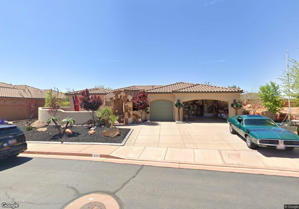
This home is located at 119 N Firerock Trail, Ivins, UT 84738 and is currently estimated at $813,394, approximately $327 per square foot. 119 N Firerock Trail is a home with nearby schools including Snow Canyon Middle School, Lava Ridge Intermediate School, and Snow Canyon High School.
Ownership History
Date
Name
Owned For
Owner Type
Purchase Details
Closed on
Dec 18, 2014
Sold by
Papanikolas Business Enterprises Inc
Bought by
Mellito Louis and Chalet Linda
Current Estimated Value
Home Financials for this Owner
Home Financials are based on the most recent Mortgage that was taken out on this home.
Original Mortgage
$410,500
Outstanding Balance
$315,366
Interest Rate
4%
Mortgage Type
VA
Estimated Equity
$498,028
Purchase Details
Closed on
Dec 2, 2013
Sold by
Blue Cactus Development Ltd
Bought by
Papanikolas Business Enterprises Inc
Purchase Details
Closed on
Apr 5, 2012
Sold by
Vwmw Investments Llc
Bought by
Blue Cactus Development Ltd
Purchase Details
Closed on
Aug 16, 2007
Sold by
Walton Val D and Walton Margie R
Bought by
Vwmw Investments Llc
Create a Home Valuation Report for This Property
The Home Valuation Report is an in-depth analysis detailing your home's value as well as a comparison with similar homes in the area
Home Values in the Area
Average Home Value in this Area
Purchase History
| Date | Buyer | Sale Price | Title Company |
|---|---|---|---|
| Mellito Louis | -- | Southern Utah Title | |
| Papanikolas Business Enterprises Inc | -- | None Available | |
| Blue Cactus Development Ltd | -- | Southern Utah Title | |
| Vwmw Investments Llc | -- | Accommodation |
Source: Public Records
Mortgage History
| Date | Status | Borrower | Loan Amount |
|---|---|---|---|
| Open | Mellito Louis | $410,500 |
Source: Public Records
Tax History Compared to Growth
Tax History
| Year | Tax Paid | Tax Assessment Tax Assessment Total Assessment is a certain percentage of the fair market value that is determined by local assessors to be the total taxable value of land and additions on the property. | Land | Improvement |
|---|---|---|---|---|
| 2025 | $2,670 | $399,795 | $123,750 | $276,045 |
| 2023 | $1,105 | $414,590 | $123,750 | $290,840 |
| 2022 | $1,105 | $408,045 | $123,750 | $284,295 |
| 2021 | $567 | $567,400 | $150,000 | $417,400 |
| 2020 | $297 | $502,300 | $140,000 | $362,300 |
| 2019 | $2,398 | $454,800 | $100,000 | $354,800 |
| 2018 | $120 | $246,015 | $0 | $0 |
| 2017 | $0 | $228,635 | $0 | $0 |
| 2016 | $2,397 | $210,265 | $0 | $0 |
| 2015 | -- | $205,370 | $0 | $0 |
| 2014 | $1,754 | $148,830 | $0 | $0 |
Source: Public Records
Map
Nearby Homes
- 108 N Arrowhead Ln
- 480 W Tonapah Way
- 19 N 640 W
- 26 N 640 W
- 12 N 640 W
- 576 W 30 S
- 33 N 640 W
- Deacon Plan at Desert Cove
- Darius Plan at Desert Cove
- Harris Plan at Desert Cove
- Powell Plan at Desert Cove
- Pinecrest Plan at Desert Cove
- 582 W W 80 S
- 543 W 80 S
- 97 S 495 W
- 208 S 620 W
- 692 W Desert Dove Ln Unit (lot 3)
- 744 W Desert Dove Ln Unit (lot 7)
- 222 S 620 W
- 88 N Apex Ln
- 105 N Firerock Trail
- 92 N Arrowhead Ln
- 92 N Arrowhead Ln Unit 13
- 126 N Arrowhead Ln
- 147 N Tenaya Ct
- 520 W Tenaya Dr
- 93 N Firerock Trail
- 0 N Firerock Trail
- 13 N Arrowhead Ln
- 0 Arrowhead Ln
- 13 N Arrowhead Ln Unit 13
- 182 N Arrowhead Ln
- 138 N Arrowhead Ln Unit 10
- 509 W Tonapah Way
- 159 N Tenaya Ct
- 68 N Arrowhead Ln
- 506 W Tenaya Dr Unit 58
- 506 W Tenaya Dr
- 0 N Tenaya Ct
- Lot #15 N Tenaya Ct