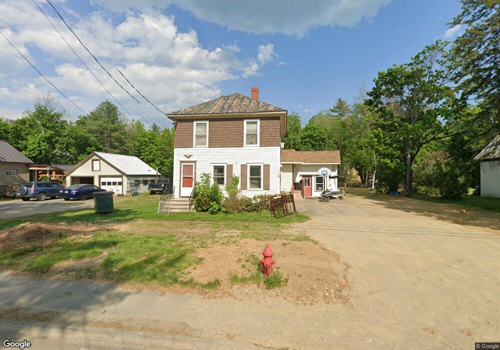
119 N Main St Strong, ME 04983
Estimated Value: $165,000 - $264,000
3
Beds
2
Baths
572
Sq Ft
$367/Sq Ft
Est. Value
About This Home
This home is located at 119 N Main St, Strong, ME 04983 and is currently estimated at $209,852, approximately $366 per square foot. 119 N Main St is a home with nearby schools including Mt. Abram Regional High School.
Ownership History
Date
Name
Owned For
Owner Type
Purchase Details
Closed on
Oct 7, 2022
Sold by
Luce Frederick N and Luce Cheryl
Bought by
Wood Jeremiah
Current Estimated Value
Home Financials for this Owner
Home Financials are based on the most recent Mortgage that was taken out on this home.
Original Mortgage
$161,634
Outstanding Balance
$154,579
Interest Rate
5.55%
Mortgage Type
Purchase Money Mortgage
Estimated Equity
$55,273
Purchase Details
Closed on
Sep 24, 2007
Sold by
Bracy Stephen M and Bracy Esther N
Bought by
Luce Frederick N and Luce Cheryl
Home Financials for this Owner
Home Financials are based on the most recent Mortgage that was taken out on this home.
Original Mortgage
$160,000
Interest Rate
6.63%
Mortgage Type
Commercial
Create a Home Valuation Report for This Property
The Home Valuation Report is an in-depth analysis detailing your home's value as well as a comparison with similar homes in the area
Home Values in the Area
Average Home Value in this Area
Purchase History
| Date | Buyer | Sale Price | Title Company |
|---|---|---|---|
| Wood Jeremiah | $158,000 | None Available | |
| Luce Frederick N | -- | -- |
Source: Public Records
Mortgage History
| Date | Status | Borrower | Loan Amount |
|---|---|---|---|
| Open | Wood Jeremiah | $161,634 | |
| Previous Owner | Luce Frederick N | $160,000 | |
| Previous Owner | Luce Frederick N | $88,000 |
Source: Public Records
Tax History Compared to Growth
Tax History
| Year | Tax Paid | Tax Assessment Tax Assessment Total Assessment is a certain percentage of the fair market value that is determined by local assessors to be the total taxable value of land and additions on the property. | Land | Improvement |
|---|---|---|---|---|
| 2024 | $1,610 | $91,480 | $18,200 | $73,280 |
| 2023 | $1,464 | $91,480 | $18,200 | $73,280 |
| 2022 | $1,445 | $91,480 | $18,200 | $73,280 |
| 2021 | $1,509 | $91,480 | $18,200 | $73,280 |
| 2020 | $1,564 | $91,480 | $18,200 | $73,280 |
| 2019 | $1,628 | $91,480 | $18,200 | $73,280 |
| 2018 | $1,418 | $91,480 | $18,200 | $73,280 |
| 2017 | $1,317 | $91,480 | $18,200 | $73,280 |
| 2016 | $1,299 | $91,480 | $18,200 | $73,280 |
| 2015 | $1,345 | $91,480 | $18,200 | $73,280 |
| 2013 | $1,171 | $91,480 | $18,200 | $73,280 |
Source: Public Records
Map
Nearby Homes
- 16 Whitetail Dr
- U03-68-C Tbd
- 83 Lambert Hill Rd
- 18 N Main St
- 44 Norton Hill Rd
- 29 River St
- 22 W Freeman Rd
- 162.7 Collins Dr
- R-5 13-A Norton Hill Rd
- 43 Brookside Ln
- MR11 L35 Burbank Hill Rd
- 9 Beechnut Ridge
- Lot 4 Taylor Hill Rd
- 68 S Strong Rd
- 4 Cousineaus Tory Hill Heights
- 722 Farmington Rd
- MR7 L31&37 Taylor Hill Rd
- 97 Lake St
- 152 Johnson Rd
- Lot 12 Barker Rd
- 125 N Main St
- 117 N Main St
- 120 N Main St
- 113 N Main St
- 118 N Main St
- 129 N Main St
- 122 N Main St
- 109 N Main St
- 128 N Main St
- 132 N Main St
- 41 Flag Star Dr
- 135 N Main St
- 105 N Main St
- 136 N Main St
- 6 Flag Star Dr
- 21 Flag Star Dr
- 99999 Flag Star Rd
- 101 N Main St
- 0 Elizabeth St Unit 1027558
- 102 N Main St