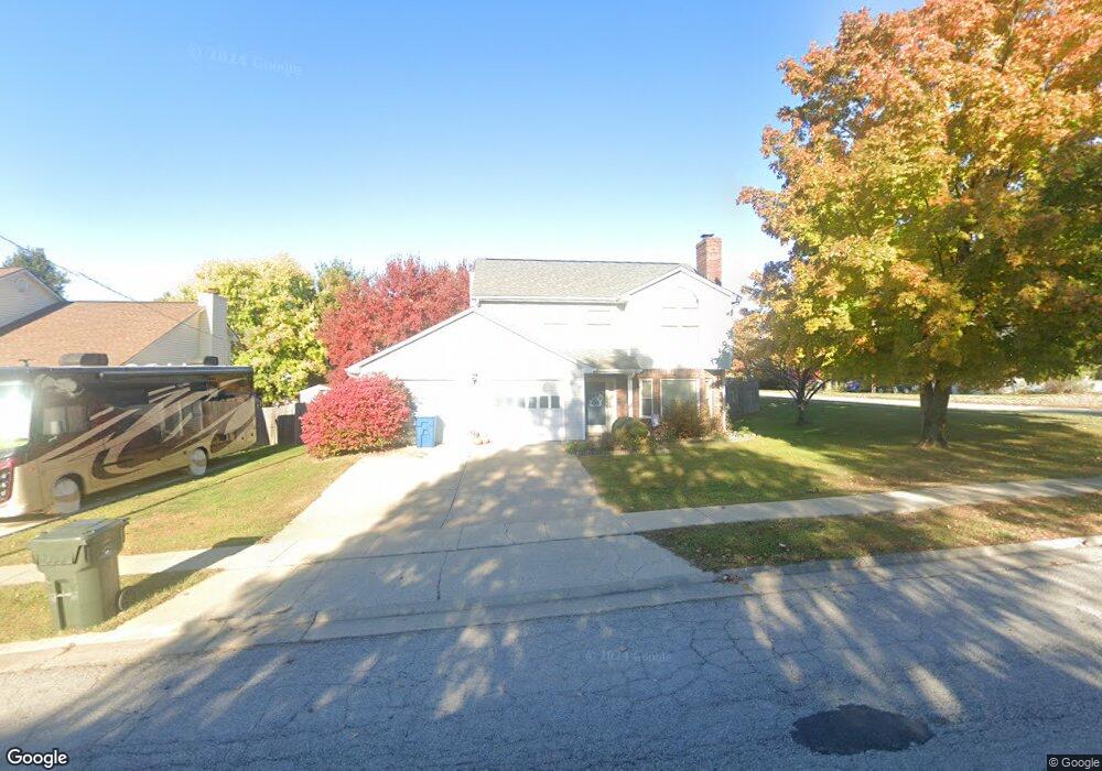
119 Redding Rd Georgetown, KY 40324
South Scott County NeighborhoodEstimated Value: $300,000 - $329,000
Studio
--
Bath
1,800
Sq Ft
$174/Sq Ft
Est. Value
About This Home
This home is located at 119 Redding Rd, Georgetown, KY 40324 and is currently estimated at $313,283, approximately $174 per square foot. 119 Redding Rd is a home located in Scott County with nearby schools including Southern Elementary School, Georgetown Middle School, and Scott County High School.
Ownership History
Date
Name
Owned For
Owner Type
Purchase Details
Closed on
Jun 23, 2012
Sold by
West Jonathan V
Bought by
West Michelle R
Current Estimated Value
Create a Home Valuation Report for This Property
The Home Valuation Report is an in-depth analysis detailing your home's value as well as a comparison with similar homes in the area
Home Values in the Area
Average Home Value in this Area
Purchase History
| Date | Buyer | Sale Price | Title Company |
|---|---|---|---|
| West Michelle R | -- | None Available |
Source: Public Records
Tax History
| Year | Tax Paid | Tax Assessment Tax Assessment Total Assessment is a certain percentage of the fair market value that is determined by local assessors to be the total taxable value of land and additions on the property. | Land | Improvement |
|---|---|---|---|---|
| 2025 | $2,360 | $265,000 | $0 | $0 |
| 2024 | $2,200 | $244,600 | $0 | $0 |
| 2023 | $2,104 | $232,000 | $40,000 | $192,000 |
| 2022 | $1,701 | $200,000 | $35,000 | $165,000 |
| 2021 | $1,748 | $185,600 | $35,000 | $150,600 |
| 2020 | $1,502 | $174,800 | $35,000 | $139,800 |
| 2019 | $1,451 | $166,200 | $0 | $0 |
| 2018 | $1,352 | $155,800 | $0 | $0 |
| 2017 | $1,250 | $143,400 | $0 | $0 |
| 2016 | $1,155 | $143,400 | $0 | $0 |
| 2015 | $1,090 | $136,200 | $0 | $0 |
| 2014 | $1,129 | $136,200 | $0 | $0 |
| 2011 | $84 | $136,200 | $0 | $0 |
Source: Public Records
Map
Nearby Homes
- 512 Pocahontas Trail
- 809 Pocahontas Trail
- 1215 Seminole Trail
- 232 W Showalter Dr
- 113 Walden Cove Unit 3I
- 264 W Showalter Dr
- 251 W Showalter Dr
- 106 Somerset Cove
- 111 Hillside Dr
- 206 Hiawatha Trail
- 199 Hawthorne Dr
- 115 Victor Place
- 1117 Pawnee Trail
- 104 Bronte Place
- 208 Montgomery Ave
- 117 Christal Dr
- 107 Oconner Ct
- 1026 Parkside Dr
- 110 Sea Pines Way
- 108 Pinwheel Ct
- 121 Redding Rd
- 211 Hutchins Dr
- 115 Redding Rd
- 123 Redding Rd
- 120 Redding Rd
- 703 Pocahontas Trail
- 118 Redding Rd
- 209 Hutchins Dr
- 210 Hutchins Dr
- 122 Redding Rd
- 113 Redding Rd
- 705 Pocahontas Trail
- 208 Hutchins Dr
- 116 Redding Rd
- 207 Hutchins Dr
- 707 Pocahontas Trail
- 109 Redding Rd
- 107 Redding Rd
- 206 Hutchins Dr
- 114 Redding Rd