
Seller's Agent in 2025
Wynne Lord
Coldwell Banker Realty
(860) 833-3896
20 in this area
134 Total Sales
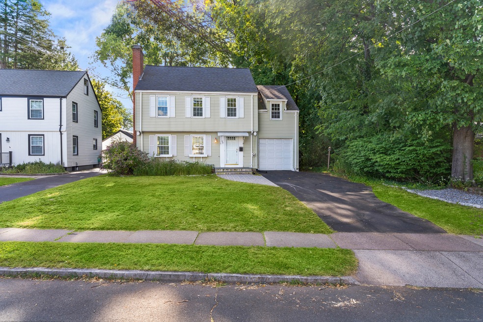
Welcome to 119 Robin Road in West Hartford, a desirable neighborhood less than a mile from vibrant West Hartford Center and a few blocks away from highly ranked Morley Elementary School. This colonial style home combines timeless character with hardwood flooring throughout, creating a warm and inviting feel. The living room features a cozy fireplace, abundant natural light, and built-ins for added charm. A formal dining room seamlessly connects to the living space and opens to a screened porch. The main level is completed by a half bathroom. Upstairs, you'll find 3 spacious bedrooms with generous sized closets and 1 full bathroom. The walk-up attic offers additional space and storage. A partially finished basement adds even more versatility, ideal for a home office, gym, or playroom. The backyard features a private .32 acres lot with plenty of privacy for the perfect outdoor space, with a patio ideal for entertaining!
Last Agent to Sell the Property
Coldwell Banker Realty Brokerage Phone: (860) 833-3896 License #RES.0805482 Listed on: 09/09/2025
| Date | Type | Sale Price | Title Company |
|---|---|---|---|
| Warranty Deed | $455,000 | -- | |
| Quit Claim Deed | -- | -- | |
| Quit Claim Deed | -- | -- | |
| Warranty Deed | $320,000 | -- | |
| Warranty Deed | $243,000 | -- | |
| Warranty Deed | $145,000 | -- |
| Date | Status | Loan Amount | Loan Type |
|---|---|---|---|
| Open | $441,350 | Future Advance Clause Open End Mortgage | |
| Previous Owner | $239,700 | New Conventional |
| Date | Event | Price | List to Sale | Price per Sq Ft |
|---|---|---|---|---|
| 10/10/2025 10/10/25 | Sold | $455,000 | +3.6% | $239 / Sq Ft |
| 10/08/2025 10/08/25 | Pending | -- | -- | -- |
| 09/09/2025 09/09/25 | For Sale | $439,000 | -- | $230 / Sq Ft |
| Year | Tax Paid | Tax Assessment Tax Assessment Total Assessment is a certain percentage of the fair market value that is determined by local assessors to be the total taxable value of land and additions on the property. | Land | Improvement |
|---|---|---|---|---|
| 2025 | $10,341 | $230,930 | $95,060 | $135,870 |
| 2024 | $9,780 | $230,930 | $95,060 | $135,870 |
| 2023 | $9,450 | $230,930 | $95,060 | $135,870 |
| 2022 | $9,394 | $230,930 | $95,060 | $135,870 |
| 2021 | $9,659 | $227,710 | $106,260 | $121,450 |
| 2020 | $8,714 | $208,460 | $93,940 | $114,520 |
| 2019 | $8,714 | $208,460 | $93,940 | $114,520 |
| 2018 | $8,547 | $208,460 | $93,940 | $114,520 |
| 2017 | $8,555 | $208,460 | $93,940 | $114,520 |
| 2016 | $8,073 | $204,330 | $80,570 | $123,760 |
| 2015 | $7,828 | $204,330 | $80,570 | $123,760 |
| 2014 | $7,636 | $204,330 | $80,570 | $123,760 |
Seller's Agent in 2025
Wynne Lord
Coldwell Banker Realty
(860) 833-3896
20 in this area
134 Total Sales
Buyer's Agent in 2025
John Lepore
Berkshire Hathaway Home Services
(860) 798-7844
248 in this area
517 Total Sales
K
Buyer Co-Listing Agent in 2025
Kevin Eagan
Berkshire Hathaway Home Services
(860) 416-3333
150 in this area
280 Total Sales
Source: SmartMLS
MLS Number: 24125119
APN: WHAR-000008F-004651-000119
Disclaimer: Certain information contained herein is derived from information provided by parties other than Homes.com. All information provided is deemed reliable, but is not guaranteed to be accurate and should be independently verified.
![]() IDX information is provided exclusively for personal, non-commercial use, and may not be used for any purpose other than to identify prospective properties consumers may be interested in purchasing. Information is deemed reliable but not guaranteed.
IDX information is provided exclusively for personal, non-commercial use, and may not be used for any purpose other than to identify prospective properties consumers may be interested in purchasing. Information is deemed reliable but not guaranteed.