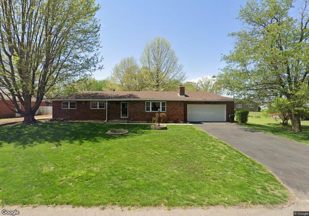
119 S Eagan St Republic, MO 65738
Estimated Value: $231,689 - $238,000
3
Beds
2
Baths
1,519
Sq Ft
$155/Sq Ft
Est. Value
About This Home
This home is located at 119 S Eagan St, Republic, MO 65738 and is currently estimated at $234,922, approximately $154 per square foot. 119 S Eagan St is a home located in Greene County with nearby schools including Schofield Elementary School, Republic Middle School, and Republic High School.
Ownership History
Date
Name
Owned For
Owner Type
Purchase Details
Closed on
Nov 20, 2014
Sold by
Lane Jennifer Lee
Bought by
Lane Joe R
Current Estimated Value
Purchase Details
Closed on
Nov 22, 2010
Sold by
Hillebrenner Marjory A
Bought by
Lane Joe R
Home Financials for this Owner
Home Financials are based on the most recent Mortgage that was taken out on this home.
Original Mortgage
$86,800
Interest Rate
4.17%
Mortgage Type
New Conventional
Create a Home Valuation Report for This Property
The Home Valuation Report is an in-depth analysis detailing your home's value as well as a comparison with similar homes in the area
Home Values in the Area
Average Home Value in this Area
Purchase History
| Date | Buyer | Sale Price | Title Company |
|---|---|---|---|
| Lane Joe R | -- | None Available | |
| Lane Joe R | -- | Lincoln Land Title |
Source: Public Records
Mortgage History
| Date | Status | Borrower | Loan Amount |
|---|---|---|---|
| Previous Owner | Lane Joe R | $86,800 |
Source: Public Records
Tax History
| Year | Tax Paid | Tax Assessment Tax Assessment Total Assessment is a certain percentage of the fair market value that is determined by local assessors to be the total taxable value of land and additions on the property. | Land | Improvement |
|---|---|---|---|---|
| 2025 | $1,398 | $28,010 | $5,700 | $22,310 |
| 2024 | $1,398 | $25,020 | $4,750 | $20,270 |
| 2023 | $1,371 | $25,020 | $4,750 | $20,270 |
| 2022 | $1,202 | $21,830 | $4,750 | $17,080 |
| 2021 | $1,195 | $21,830 | $4,750 | $17,080 |
| 2020 | $1,214 | $21,830 | $4,750 | $17,080 |
| 2019 | $1,209 | $21,830 | $4,750 | $17,080 |
| 2018 | $1,007 | $17,560 | $3,800 | $13,760 |
| 2017 | $998 | $15,730 | $3,800 | $11,930 |
| 2016 | $904 | $15,730 | $3,800 | $11,930 |
| 2015 | $901 | $15,730 | $3,800 | $11,930 |
| 2014 | $909 | $15,730 | $3,800 | $11,930 |
Source: Public Records
Map
Nearby Homes
- 114 S Eagan St
- 421 W Elm St
- 548 S Buxton Ln
- 347 W Elm St
- 393 N Ladera Dr
- 0 Highway 60 Unit 60308100
- 0 Highway 60 Unit 60308095
- 411 N College Ave
- 513 W Logan St
- 609 S Mckee Ave
- 1001 W Broad St
- 511 S Main Ave
- 000 W Crestview Ln
- 319 W Hines St
- 636 N Dana Ave
- 473 S Michelle Ave
- 647 N Dana Ave
- 4507 S Farm Road 71
- 1135 W Broad St
- 1213 N London Place
- 121 S Eagan St
- 546 W Elm St
- 557 W Mill St
- 548 W Elm St
- 120 S Concordia Ave
- 122 S Concordia Ave
- 116 S Eagan St
- 552 W Elm St
- 120 S Eagan St
- 205 S Eagan St
- 204 S Eagan St
- 560 W Mill St
- 205 S Jackson St
- 113 S Concordia Ave
- 212 S Eagan St
- 546 W State Highway 174
- 546 State Highway 174
- 219 S Eagan St
- 120 S Jackson St
- 561 W Scotland St
Your Personal Tour Guide
Ask me questions while you tour the home.