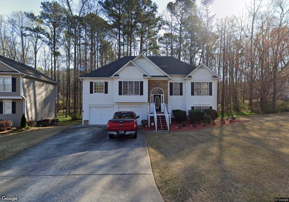
119 Sable Trace Ln Acworth, GA 30102
Oak Grove NeighborhoodEstimated Value: $397,000 - $420,228
5
Beds
3
Baths
2,070
Sq Ft
$197/Sq Ft
Est. Value
About This Home
This home is located at 119 Sable Trace Ln, Acworth, GA 30102 and is currently estimated at $408,614, approximately $197 per square foot. 119 Sable Trace Ln is a home located in Cherokee County with nearby schools including Oak Grove Elementary School, E. T. Booth Middle School, and Etowah High School.
Ownership History
Date
Name
Owned For
Owner Type
Purchase Details
Closed on
Mar 16, 2001
Sold by
Woodall Const Co Inc
Bought by
Roberts Bobby G and Roberts Teresa R
Current Estimated Value
Home Financials for this Owner
Home Financials are based on the most recent Mortgage that was taken out on this home.
Original Mortgage
$183,237
Interest Rate
7.14%
Mortgage Type
VA
Create a Home Valuation Report for This Property
The Home Valuation Report is an in-depth analysis detailing your home's value as well as a comparison with similar homes in the area
Home Values in the Area
Average Home Value in this Area
Purchase History
| Date | Buyer | Sale Price | Title Company |
|---|---|---|---|
| Roberts Bobby G | $177,900 | -- |
Source: Public Records
Mortgage History
| Date | Status | Borrower | Loan Amount |
|---|---|---|---|
| Previous Owner | Roberts Bobby G | $183,237 |
Source: Public Records
Tax History
| Year | Tax Paid | Tax Assessment Tax Assessment Total Assessment is a certain percentage of the fair market value that is determined by local assessors to be the total taxable value of land and additions on the property. | Land | Improvement |
|---|---|---|---|---|
| 2025 | $864 | $153,800 | $34,000 | $119,800 |
| 2024 | $841 | $154,680 | $34,000 | $120,680 |
| 2023 | $705 | $155,680 | $34,000 | $121,680 |
| 2022 | $795 | $128,200 | $32,000 | $96,200 |
| 2021 | $772 | $104,480 | $24,000 | $80,480 |
| 2020 | $2,613 | $97,680 | $22,000 | $75,680 |
| 2019 | $2,560 | $95,440 | $22,000 | $73,440 |
| 2018 | $2,347 | $85,720 | $19,200 | $66,520 |
| 2017 | $2,340 | $211,700 | $19,200 | $65,480 |
| 2016 | $2,086 | $184,900 | $19,200 | $54,760 |
| 2015 | $1,868 | $164,600 | $15,200 | $50,640 |
| 2014 | $1,825 | $160,600 | $13,000 | $51,240 |
Source: Public Records
Map
Nearby Homes
- 6390 Woodstock Rd
- 204 Queensbury Ct
- 585 Lee Dr
- 307 Queensbury Walk
- 1030 Queensbury Run Unit 1
- 1037 Queensbury Run
- 3106 Cambridge Mill St
- 736 Coventry Cove Way
- 740 Coventry Cove Way
- 744 Coventry Cove Way
- 3102 Cambridge Mill St
- 748 Coventry Cove Way
- 752 Coventry Cove Way
- 756 Coventry Cove Way
- 1856 W Elmwood Dr
- 321 Brighton Bend Ln
- 325 Brighton Bend Ln
- 333 Brighton Bend Ln
- 337 Brighton Bend Ln
- 341 Brighton Bend Ln
- 117 Sable Trace Ln
- 112 Sable Trace Ln
- 115 Sable Trace Ln
- 114 Sable Trace Ln
- 121 Sable Trace Ln
- 118 Sable Trace Ln
- 116 Sable Trace Ln
- 113 Sable Trace Ln
- 110 Sable Trace Ln
- 302 Sable Trace Ct
- 221 Sable Trace Dr
- 111 Sable Trace Ln
- 219 Sable Trace Dr
- 108 Sable Trace Ln
- 304 Sable Trace Ct
- 109 Sable Trace Ln
- 223 Sable Trace Dr Unit 33
- 223 Sable Trace Dr
- 225 Sable Trace Dr
- 217 Sable Trace Dr
Your Personal Tour Guide
Ask me questions while you tour the home.