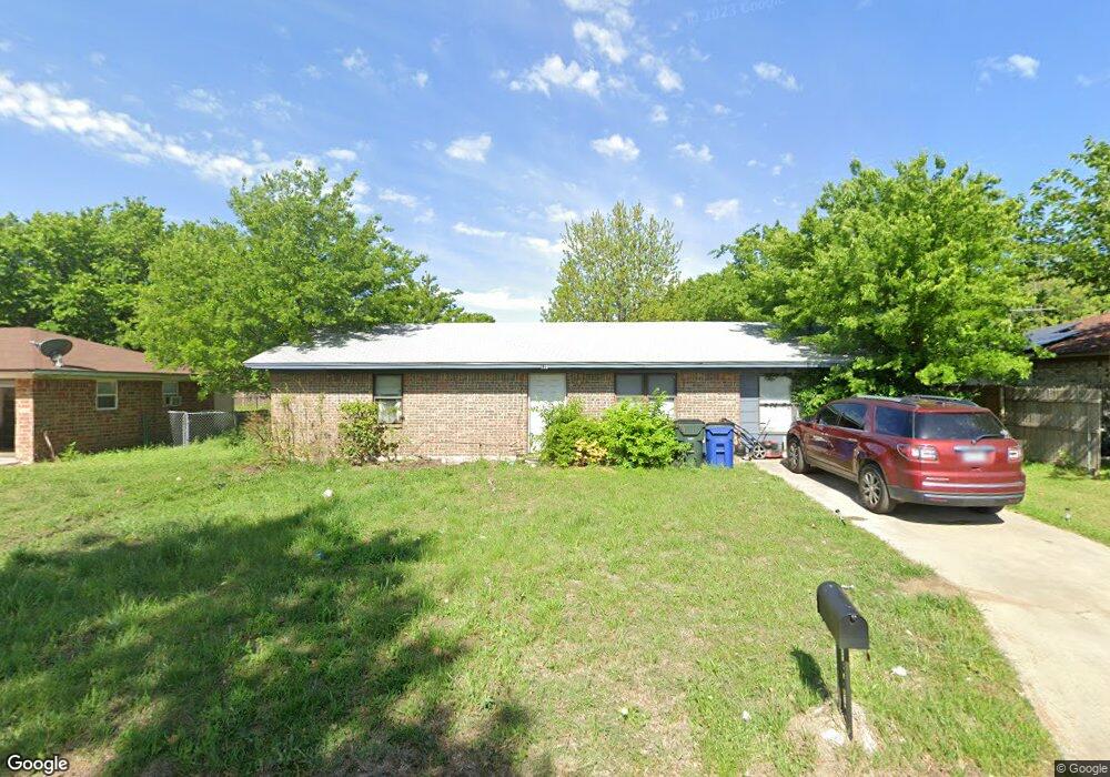
119 Southside Dr Sanger, TX 76266
Estimated Value: $199,000 - $264,000
3
Beds
1
Bath
912
Sq Ft
$239/Sq Ft
Est. Value
About This Home
This home is located at 119 Southside Dr, Sanger, TX 76266 and is currently estimated at $217,618, approximately $238 per square foot. 119 Southside Dr is a home located in Denton County with nearby schools including Chisholm Trail Elementary School, Clear Creek Intermediate School, and Sanger Sixth Grade Campus.
Ownership History
Date
Name
Owned For
Owner Type
Purchase Details
Closed on
Dec 15, 2014
Sold by
Eaton Darla M
Bought by
Darla M Eaton Family Trust and Eaton Darla M
Current Estimated Value
Purchase Details
Closed on
Jan 20, 2009
Sold by
James Virgil David
Bought by
James Virgil David and Virgil David James Living Trust
Purchase Details
Closed on
Dec 15, 1997
Sold by
Nizovitz Mildred I
Bought by
James Virgil D
Create a Home Valuation Report for This Property
The Home Valuation Report is an in-depth analysis detailing your home's value as well as a comparison with similar homes in the area
Home Values in the Area
Average Home Value in this Area
Purchase History
| Date | Buyer | Sale Price | Title Company |
|---|---|---|---|
| Darla M Eaton Family Trust | -- | None Available | |
| James Virgil David | -- | None Available | |
| James Virgil D | -- | -- |
Source: Public Records
Tax History Compared to Growth
Tax History
| Year | Tax Paid | Tax Assessment Tax Assessment Total Assessment is a certain percentage of the fair market value that is determined by local assessors to be the total taxable value of land and additions on the property. | Land | Improvement |
|---|---|---|---|---|
| 2025 | $1,849 | $154,554 | $68,188 | $86,366 |
| 2024 | $3,002 | $148,528 | $0 | $0 |
| 2023 | $1,580 | $135,025 | $51,141 | $119,523 |
| 2022 | $2,722 | $122,750 | $51,141 | $102,299 |
| 2021 | $2,345 | $126,334 | $32,815 | $93,519 |
| 2020 | $2,245 | $101,446 | $32,815 | $79,531 |
| 2019 | $2,100 | $92,224 | $32,815 | $78,496 |
| 2018 | $1,919 | $83,840 | $23,440 | $60,400 |
| 2017 | $1,914 | $83,215 | $23,440 | $73,227 |
| 2016 | $1,740 | $75,650 | $13,638 | $62,012 |
| 2015 | $1,294 | $64,585 | $13,638 | $50,947 |
| 2014 | $1,294 | $55,689 | $17,938 | $37,751 |
| 2013 | -- | $53,766 | $17,938 | $35,828 |
Source: Public Records
Map
Nearby Homes
- 130 Southside Dr
- 202 Southland Dr
- 321 Quail Crossing Dr
- 319 Quail Crossing Dr
- 2000 S Stemmons St
- 209 Southland Dr
- 2004 S Stemmons St
- 226 Hillcrest St
- 212 Diane Dr
- 124 Morning Glory
- 114 Pintail Ln
- 117 Teal Rd
- 113 Diane Dr
- 108 Magnolia Dr
- 109 Colonial Heights
- 185 Aster Dr
- 942 First St
- 936 First St
- 141 Shady Grove Dr
- 505 Houston St
- 117 Southside Dr
- 121 Southside Dr
- 118 Southmeadow Dr
- 120 Southmeadow Dr
- 115 Southside Dr
- 123 Southside Dr
- 116 Southmeadow Dr
- 120 Southside Dr
- 122 Southside Dr
- 118 Southside Dr
- 113 Southside Dr
- 100 Southpark Ct
- 114 Southmeadow Dr
- 124 Southside Dr
- 125 Southside Dr
- 126 Southside Dr
- 116 Southside Dr
- 111 Southside Dr
- 112 Southmeadow Dr
- 102 Southpark Ct