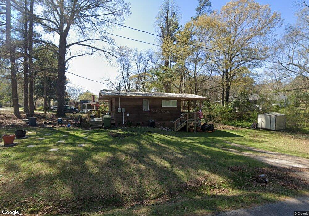
119 Sunset Dr Lagrange, GA 30240
Estimated Value: $65,000 - $129,000
1
Bed
1
Bath
384
Sq Ft
$234/Sq Ft
Est. Value
About This Home
This home is located at 119 Sunset Dr, Lagrange, GA 30240 and is currently estimated at $89,985, approximately $234 per square foot. 119 Sunset Dr is a home located in Troup County with nearby schools including Berta Weathersbee Elementary School, Whitesville Road Elementary School, and Long Cane Elementary School.
Ownership History
Date
Name
Owned For
Owner Type
Purchase Details
Closed on
Nov 17, 2016
Sold by
51 Reed Drive Llc
Bought by
Sherman Neil and Sherman Gail M
Current Estimated Value
Home Financials for this Owner
Home Financials are based on the most recent Mortgage that was taken out on this home.
Original Mortgage
$44,577
Outstanding Balance
$36,008
Interest Rate
3.87%
Mortgage Type
FHA
Estimated Equity
$53,977
Purchase Details
Closed on
May 8, 2015
Sold by
Baikey Charlotte Wynette
Bought by
51 Reed Drive Llc
Purchase Details
Closed on
May 20, 1996
Sold by
Artis A Brown
Bought by
Bailey Bailey W and Bailey Wynettet
Purchase Details
Closed on
Feb 24, 1992
Bought by
Artis A Brown
Purchase Details
Closed on
Jul 12, 1991
Purchase Details
Closed on
Jan 1, 1964
Create a Home Valuation Report for This Property
The Home Valuation Report is an in-depth analysis detailing your home's value as well as a comparison with similar homes in the area
Purchase History
| Date | Buyer | Sale Price | Title Company |
|---|---|---|---|
| Sherman Neil | $45,400 | -- | |
| 51 Reed Drive Llc | $18,000 | -- | |
| Bailey Bailey W | $16,700 | -- | |
| Artis A Brown | -- | -- | |
| -- | $18,000 | -- | |
| -- | -- | -- |
Source: Public Records
Mortgage History
| Date | Status | Borrower | Loan Amount |
|---|---|---|---|
| Open | Sherman Neil | $44,577 |
Source: Public Records
Tax History
| Year | Tax Paid | Tax Assessment Tax Assessment Total Assessment is a certain percentage of the fair market value that is determined by local assessors to be the total taxable value of land and additions on the property. | Land | Improvement |
|---|---|---|---|---|
| 2025 | $381 | $13,960 | $3,920 | $10,040 |
| 2024 | $345 | $12,640 | $3,920 | $8,720 |
| 2023 | $346 | $12,680 | $3,920 | $8,760 |
| 2022 | $341 | $12,200 | $3,920 | $8,280 |
| 2021 | $308 | $10,200 | $3,160 | $7,040 |
| 2020 | $308 | $10,200 | $3,160 | $7,040 |
| 2019 | $258 | $8,560 | $3,160 | $5,400 |
| 2018 | $247 | $8,200 | $3,320 | $4,880 |
| 2017 | $247 | $8,200 | $3,320 | $4,880 |
| 2016 | $217 | $7,200 | $2,920 | $4,280 |
| 2015 | $157 | $5,195 | $2,352 | $2,843 |
| 2014 | -- | $5,046 | $2,352 | $2,694 |
| 2013 | -- | $5,212 | $2,352 | $2,860 |
Source: Public Records
Map
Nearby Homes
- 3 Reed Dr
- 0 Unit 10514554
- 101 Crown St Unit LOT 5
- 102 Crown St Unit LOT 1
- 120 Laurel Ridge Ave E
- 149 Laurel Ridge Ave E
- 8 Horace Carter Rd
- 134 Laurel Ridge Ave E
- 0 Bradfield Dr Unit 10568803
- 107 Clark St
- 205 Grady St
- 223 Pinehaven Dr
- 608 Wilburn Ave
- 610 Wilburn Ave
- 427 Fling Rd
- 211 Moores Hill
- 0 Moores Hill
- 202 Parker Ln
- 336 Whitaker Rd
- 0 Hills and Dales Farm Rd
Your Personal Tour Guide
Ask me questions while you tour the home.