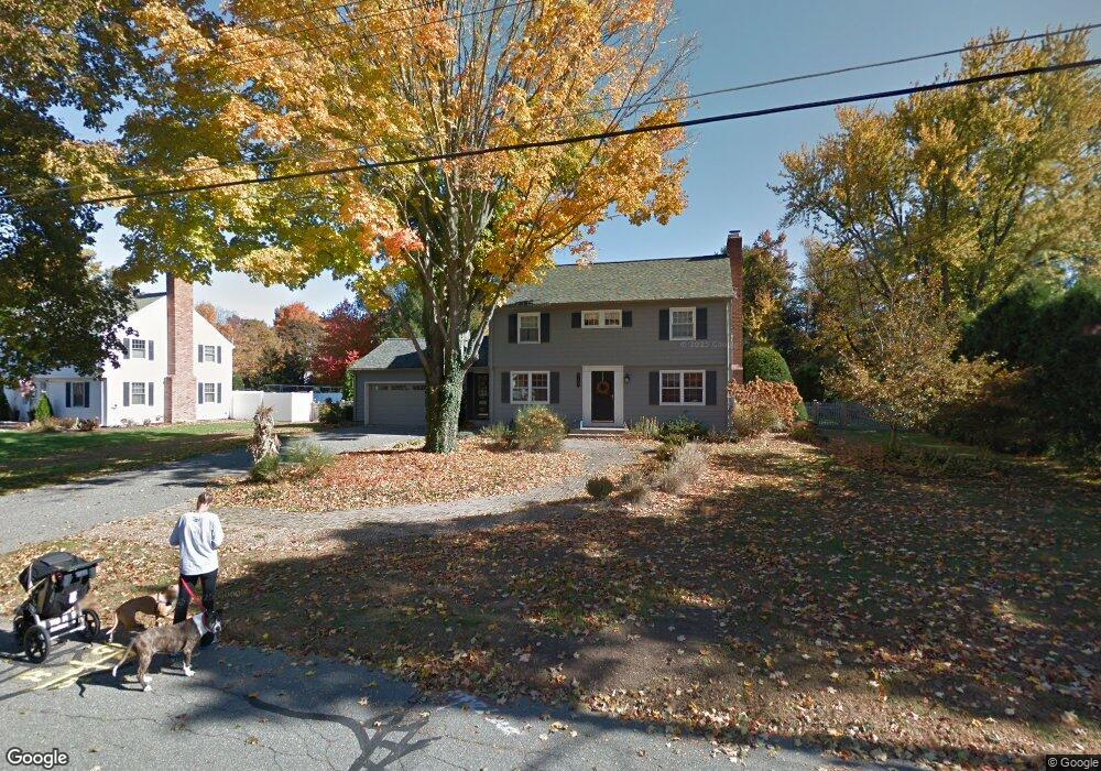
119 Viscount Rd Longmeadow, MA 01106
Estimated Value: $518,000 - $592,003
3
Beds
3
Baths
1,949
Sq Ft
$279/Sq Ft
Est. Value
About This Home
This home is located at 119 Viscount Rd, Longmeadow, MA 01106 and is currently estimated at $543,751, approximately $278 per square foot. 119 Viscount Rd is a home located in Hampden County with nearby schools including Blueberry Hill, Glenbrook Middle School, and Longmeadow High School.
Ownership History
Date
Name
Owned For
Owner Type
Purchase Details
Closed on
Feb 27, 1998
Sold by
Mari Mary E
Bought by
Gazillo Stephen A and Gazillo Joan R
Current Estimated Value
Home Financials for this Owner
Home Financials are based on the most recent Mortgage that was taken out on this home.
Original Mortgage
$186,900
Interest Rate
6.85%
Mortgage Type
Purchase Money Mortgage
Create a Home Valuation Report for This Property
The Home Valuation Report is an in-depth analysis detailing your home's value as well as a comparison with similar homes in the area
Home Values in the Area
Average Home Value in this Area
Purchase History
| Date | Buyer | Sale Price | Title Company |
|---|---|---|---|
| Gazillo Stephen A | $219,900 | -- |
Source: Public Records
Mortgage History
| Date | Status | Borrower | Loan Amount |
|---|---|---|---|
| Open | Gazillo Stephen A | $179,000 | |
| Closed | Gazillo Stephen A | $185,550 | |
| Closed | Gazillo Stephen A | $186,900 |
Source: Public Records
Tax History
| Year | Tax Paid | Tax Assessment Tax Assessment Total Assessment is a certain percentage of the fair market value that is determined by local assessors to be the total taxable value of land and additions on the property. | Land | Improvement |
|---|---|---|---|---|
| 2025 | $10,896 | $515,900 | $172,000 | $343,900 |
| 2024 | $10,669 | $515,900 | $172,000 | $343,900 |
| 2023 | $10,539 | $459,800 | $156,500 | $303,300 |
| 2022 | $10,144 | $411,700 | $156,500 | $255,200 |
| 2021 | $9,604 | $388,200 | $149,100 | $239,100 |
| 2020 | $9,285 | $383,500 | $149,100 | $234,400 |
| 2019 | $8,846 | $367,200 | $149,100 | $218,100 |
| 2018 | $8,173 | $335,800 | $174,100 | $161,700 |
| 2017 | $7,836 | $332,300 | $174,100 | $158,200 |
| 2016 | $7,542 | $310,000 | $161,500 | $148,500 |
| 2015 | $7,282 | $308,300 | $159,800 | $148,500 |
Source: Public Records
Map
Nearby Homes
- 53 Ashford Rd
- 111 Ashford Rd
- 330 Merriweather Dr
- 20 Kimberly Cir
- 112 Grassy Gutter Rd
- 64 Magnolia Cir
- 441 Inverness Ln
- 60 Exeter Ave
- 59 Lawrence Dr
- 211 Academy Dr
- 184 Cambridge Cir
- 63 Meadowlark Dr
- 124 Tecumseh Dr
- 53 Meadowlark Dr
- 642 Laurel St
- 58 Shady Side Dr
- 170 Hopkins Place
- 0 Dennis Rd
- 208 Birch Rd
- 70 Tennyson Dr
- 107 Viscount Rd
- 131 Viscount Rd
- 202 Captain Rd
- 118 Viscount Rd
- 214 Captain Rd
- 192 Captain Rd
- 110 Viscount Rd
- 143 Viscount Rd
- 130 Viscount Rd
- 182 Captain Rd
- 85 Viscount Rd
- 111 Caravelle Dr
- 144 Viscount Rd
- 35 Caravelle Dr
- 232 Captain Rd
- 153 Viscount Rd
- 46 Caravelle Dr
- 172 Captain Rd
- 38 E Primrose Dr
- 79 Viscount Rd
Your Personal Tour Guide
Ask me questions while you tour the home.