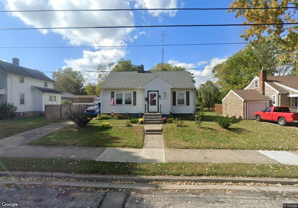
119 Willis Ave Springfield, OH 45505
Estimated Value: $119,565 - $150,000
2
Beds
1
Bath
941
Sq Ft
$149/Sq Ft
Est. Value
About This Home
This home is located at 119 Willis Ave, Springfield, OH 45505 and is currently estimated at $139,891, approximately $148 per square foot. 119 Willis Ave is a home located in Clark County with nearby schools including Mann Elementary School, Schaefer Middle School, and Springfield High School.
Ownership History
Date
Name
Owned For
Owner Type
Purchase Details
Closed on
Aug 18, 2005
Sold by
Cross Joseph L and Cross Kathleen M
Bought by
Miller Michael T
Current Estimated Value
Home Financials for this Owner
Home Financials are based on the most recent Mortgage that was taken out on this home.
Original Mortgage
$79,748
Outstanding Balance
$42,269
Interest Rate
5.8%
Mortgage Type
FHA
Estimated Equity
$97,622
Purchase Details
Closed on
Dec 19, 2000
Sold by
Cross Lynne R and Fisher Lynne R
Bought by
Cross Joseph L
Purchase Details
Closed on
May 1, 1999
Sold by
Cross Joseph L
Bought by
Cross Lynne R
Create a Home Valuation Report for This Property
The Home Valuation Report is an in-depth analysis detailing your home's value as well as a comparison with similar homes in the area
Home Values in the Area
Average Home Value in this Area
Purchase History
| Date | Buyer | Sale Price | Title Company |
|---|---|---|---|
| Miller Michael T | $81,000 | Custom Land Title Llc | |
| Cross Joseph L | -- | -- | |
| Cross Lynne R | -- | -- |
Source: Public Records
Mortgage History
| Date | Status | Borrower | Loan Amount |
|---|---|---|---|
| Open | Miller Michael T | $79,748 |
Source: Public Records
Tax History Compared to Growth
Tax History
| Year | Tax Paid | Tax Assessment Tax Assessment Total Assessment is a certain percentage of the fair market value that is determined by local assessors to be the total taxable value of land and additions on the property. | Land | Improvement |
|---|---|---|---|---|
| 2024 | $1,438 | $29,820 | $5,560 | $24,260 |
| 2023 | $1,438 | $29,820 | $5,560 | $24,260 |
| 2022 | $1,473 | $29,820 | $5,560 | $24,260 |
| 2021 | $1,151 | $21,520 | $4,340 | $17,180 |
| 2020 | $1,153 | $21,520 | $4,340 | $17,180 |
| 2019 | $1,156 | $21,520 | $4,340 | $17,180 |
| 2018 | $795 | $14,210 | $3,620 | $10,590 |
| 2017 | $794 | $19,880 | $3,619 | $16,261 |
| 2016 | $795 | $19,880 | $3,619 | $16,261 |
| 2015 | $1,138 | $19,880 | $3,619 | $16,261 |
| 2014 | $1,134 | $19,880 | $3,619 | $16,261 |
| 2013 | $1,121 | $19,880 | $3,619 | $16,261 |
Source: Public Records
Map
Nearby Homes
- 120 S Fostoria Ave
- 2702 Maplewood Ave
- 184 Willis Ave
- 112 N Burnett Rd
- 3012 E High St
- 402 Roseland Ave E
- 325 N Burnett Rd
- 438 Lawnview Ave
- 3154 Sherwood Park Dr
- 127 Bellevue Ave
- 360 Buxton Ave
- 327 Buxton Ave
- 2753 Van Buren Ave
- 2422 Lexington Ave
- 528 Geron Dr
- 3158 Meadow Wood Dr
- 2434 Irwin Ave
- 2751 Share St
- 2226 E High St
- 258 Forest Dr
- 121 Willis Ave
- 127 Willis Ave
- 2805 Maplewood Ave
- 101 Willis Ave
- 2771 Maplewood Ave
- 2771 Maplewood Ave
- 116 Willis Ave
- 112 Willis Ave
- 120 Willis Ave
- 133 Willis Ave
- 133 Willis Ave
- 110 Willis Ave
- 106 Willis Ave
- 137 Willis Ave
- 106 S Fostoria Ave
- 104 S Fostoria Ave
- 102 S Fostoria Ave
- 102 Willis Ave
- 124 S Fostoria Ave
- 145 Willis Ave