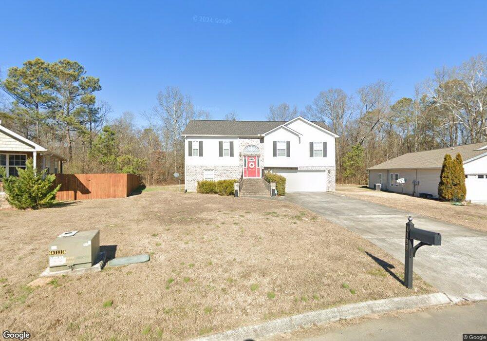
1190 Brookstone Cir Dalton, GA 30721
Estimated Value: $254,304 - $330,000
4
Beds
3
Baths
2,390
Sq Ft
$116/Sq Ft
Est. Value
About This Home
This home is located at 1190 Brookstone Cir, Dalton, GA 30721 and is currently estimated at $276,826, approximately $115 per square foot. 1190 Brookstone Cir is a home located in Whitfield County with nearby schools including Valley Point Elementary School, Valley Point Middle School, and Southeast Whitfield County High School.
Ownership History
Date
Name
Owned For
Owner Type
Purchase Details
Closed on
Apr 6, 2016
Sold by
Reid Faye B
Bought by
Reid Faye B and Reid Sherri Faye
Current Estimated Value
Purchase Details
Closed on
Jun 3, 2011
Sold by
Bryson Robert
Bought by
Reid Faye B
Home Financials for this Owner
Home Financials are based on the most recent Mortgage that was taken out on this home.
Original Mortgage
$86,250
Interest Rate
4.71%
Mortgage Type
New Conventional
Purchase Details
Closed on
Oct 2, 2007
Sold by
Not Provided
Bought by
Reid Faye B
Home Financials for this Owner
Home Financials are based on the most recent Mortgage that was taken out on this home.
Original Mortgage
$165,000
Interest Rate
6.44%
Mortgage Type
New Conventional
Purchase Details
Closed on
Jul 12, 2007
Sold by
Not Provided
Bought by
Reid Faye B
Create a Home Valuation Report for This Property
The Home Valuation Report is an in-depth analysis detailing your home's value as well as a comparison with similar homes in the area
Purchase History
| Date | Buyer | Sale Price | Title Company |
|---|---|---|---|
| Reid Faye B | -- | -- | |
| Reid Faye B | $115,000 | -- | |
| Reid Faye B | $165,000 | -- | |
| Reid Faye B | -- | -- | |
| Reid Faye B | $30,000 | -- |
Source: Public Records
Mortgage History
| Date | Status | Borrower | Loan Amount |
|---|---|---|---|
| Previous Owner | Reid Faye B | $86,250 | |
| Previous Owner | Reid Faye B | $165,000 |
Source: Public Records
Tax History
| Year | Tax Paid | Tax Assessment Tax Assessment Total Assessment is a certain percentage of the fair market value that is determined by local assessors to be the total taxable value of land and additions on the property. | Land | Improvement |
|---|---|---|---|---|
| 2025 | $2,017 | $86,567 | $11,600 | $74,967 |
| 2024 | $2,017 | $86,567 | $11,600 | $74,967 |
| 2023 | $1,998 | $66,757 | $11,000 | $55,757 |
| 2022 | $1,722 | $58,395 | $11,000 | $47,395 |
| 2021 | $1,723 | $58,395 | $11,000 | $47,395 |
| 2020 | $1,781 | $58,395 | $11,000 | $47,395 |
| 2019 | $1,811 | $58,395 | $11,000 | $47,395 |
| 2018 | $1,595 | $50,627 | $6,800 | $43,827 |
| 2017 | $1,596 | $50,627 | $6,800 | $43,827 |
| 2016 | $1,415 | $46,662 | $6,800 | $39,862 |
| 2014 | $1,256 | $46,662 | $6,800 | $39,862 |
| 2013 | -- | $46,661 | $6,800 | $39,861 |
Source: Public Records
Map
Nearby Homes
- 586 Collington Cir
- 321 Collington Cir
- 282 Collington Cir
- 162 Valley Point Dr SE
- 3737 S Dixie Hwy
- 147 Toria Trace
- 3950 S Dixie Hwy
- 0 Waterfront Way
- 139 Waterfront Way
- 169 Waterfront Way
- 3950 S Dixie Rd
- 112 Robin Hood Dr
- 116 Robin Hood Dr
- 000 S Dixie Hwy
- 122 Robin Hood Dr Unit A,B
- 122 Robin Hood Dr
- 124 Robin Hood Dr
- 171 Maurine Dr
- 243 Gaz Rd SE
- 0 Old Dixie Hwy
- 1180 Brookstone Cir
- 1200 Brookstone Cir
- 1170 Brookstone Cir Unit 13
- 1170 Brookstone Cir
- 1210 Brookstone Cir
- 1195 Brookstone Cir
- 00 Valley Point Dr SE
- 1220 Brookstone Cir
- 1160 Brookstone Cir
- 1215 Brookstone Cir
- 1155 Brookstone Cir
- 1230 Brookstone Cir
- 1225 Brookstone Cir
- 1150 Brookstone Cir
- 1125 Brookstone Cir
- 1140 Brookstone Cir
- 1115 Brookstone Cir
- 1240 Brookstone Cir
- 1235 Brookstone Cir
- 1105 Brookstone Cir
Your Personal Tour Guide
Ask me questions while you tour the home.