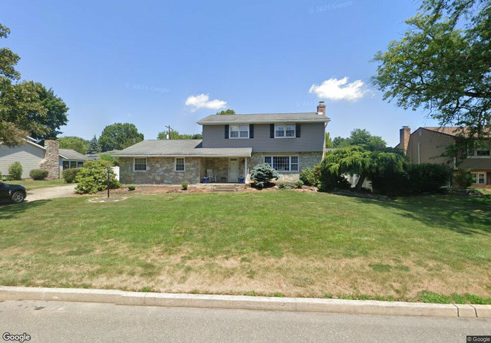
1190 Gaspar Ave Bethlehem, PA 18017
Estimated Value: $518,469 - $567,000
4
Beds
3
Baths
2,604
Sq Ft
$206/Sq Ft
Est. Value
About This Home
This home is located at 1190 Gaspar Ave, Bethlehem, PA 18017 and is currently estimated at $536,617, approximately $206 per square foot. 1190 Gaspar Ave is a home located in Northampton County with nearby schools including Hanover Elementary School, Nitschmann Middle School, and Liberty High School.
Ownership History
Date
Name
Owned For
Owner Type
Purchase Details
Closed on
Feb 25, 2009
Sold by
Deschler Michael C
Bought by
Bauer Jonathan T and Bauer Lauren L
Current Estimated Value
Home Financials for this Owner
Home Financials are based on the most recent Mortgage that was taken out on this home.
Original Mortgage
$270,019
Outstanding Balance
$167,317
Interest Rate
5.14%
Mortgage Type
FHA
Estimated Equity
$369,300
Purchase Details
Closed on
Mar 4, 2008
Sold by
Deschler Michael C and Deschler David A
Bought by
Deschler Patricia A
Create a Home Valuation Report for This Property
The Home Valuation Report is an in-depth analysis detailing your home's value as well as a comparison with similar homes in the area
Home Values in the Area
Average Home Value in this Area
Purchase History
| Date | Buyer | Sale Price | Title Company |
|---|---|---|---|
| Bauer Jonathan T | $275,000 | None Available | |
| Deschler Patricia A | -- | None Available |
Source: Public Records
Mortgage History
| Date | Status | Borrower | Loan Amount |
|---|---|---|---|
| Open | Bauer Jonathan T | $270,019 |
Source: Public Records
Tax History
| Year | Tax Paid | Tax Assessment Tax Assessment Total Assessment is a certain percentage of the fair market value that is determined by local assessors to be the total taxable value of land and additions on the property. | Land | Improvement |
|---|---|---|---|---|
| 2026 | $852 | $78,900 | $20,300 | $58,600 |
| 2025 | $852 | $78,900 | $20,300 | $58,600 |
| 2024 | $5,752 | $78,900 | $20,300 | $58,600 |
| 2023 | $5,772 | $78,900 | $20,300 | $58,600 |
| 2022 | $5,717 | $78,900 | $20,300 | $58,600 |
| 2021 | $5,671 | $78,900 | $20,300 | $58,600 |
| 2020 | $5,678 | $78,900 | $20,300 | $58,600 |
| 2019 | $5,655 | $78,900 | $20,300 | $58,600 |
| 2018 | $5,543 | $78,900 | $20,300 | $58,600 |
| 2017 | $5,503 | $78,900 | $20,300 | $58,600 |
| 2016 | -- | $78,900 | $20,300 | $58,600 |
| 2015 | -- | $78,900 | $20,300 | $58,600 |
| 2014 | -- | $78,900 | $20,300 | $58,600 |
Source: Public Records
Map
Nearby Homes
- 1330 Cherry Ave
- 1225 Brentwood Ave
- 1655 Chippendale Cir
- 4410 Greenfield Rd
- 3225 Harmor Ln
- 4435 Christine Ct
- 5514 Grace Ave
- 4701 Kathi Dr
- 1385 W MacAda Rd
- 4442 Lenox Dr
- 58 Colonial Rd
- 4628 Cheryl Dr
- 4754 Cheryl Dr
- 801 Yorkshire Rd
- 3429 Park Place
- 2268 Grove Rd
- 3424 Park Place
- 2731 Diane Blvd
- 3470 Park Place
- 1425 Roselawn Dr
Your Personal Tour Guide
Ask me questions while you tour the home.