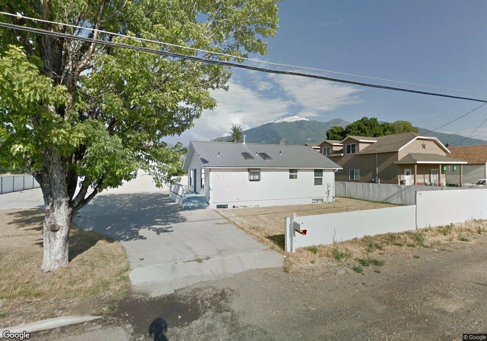
1190 N 1600 W Mapleton, UT 84664
Estimated Value: $533,000 - $594,000
4
Beds
3
Baths
2,106
Sq Ft
$269/Sq Ft
Est. Value
About This Home
This home is located at 1190 N 1600 W, Mapleton, UT 84664 and is currently estimated at $565,940, approximately $268 per square foot. 1190 N 1600 W is a home located in Utah County with nearby schools including Mapleton School, Mapleton Junior High School, and Maple Mountain High School.
Ownership History
Date
Name
Owned For
Owner Type
Purchase Details
Closed on
Dec 17, 2020
Sold by
Giboney Leslie Kay and Giboney Randy Craig
Bought by
Himes Elsie
Current Estimated Value
Home Financials for this Owner
Home Financials are based on the most recent Mortgage that was taken out on this home.
Original Mortgage
$315,000
Outstanding Balance
$280,444
Interest Rate
2.7%
Mortgage Type
New Conventional
Estimated Equity
$285,496
Purchase Details
Closed on
Jan 22, 2020
Sold by
Andrus Kyle C
Bought by
Giboney Leslie Kay and Giboney Randy Craig
Purchase Details
Closed on
Nov 21, 2012
Sold by
Secretary Of Housing & Urban Development
Bought by
Andrus Kyle C
Home Financials for this Owner
Home Financials are based on the most recent Mortgage that was taken out on this home.
Original Mortgage
$133,045
Interest Rate
3.25%
Mortgage Type
FHA
Purchase Details
Closed on
Jul 31, 2012
Sold by
Bank Of America Na
Bought by
Secretary Of Housing & Urban Development
Purchase Details
Closed on
Aug 4, 2008
Sold by
Andersen Quinn C
Bought by
Burrows Anthony W and Burrows Lindsey
Home Financials for this Owner
Home Financials are based on the most recent Mortgage that was taken out on this home.
Original Mortgage
$214,739
Interest Rate
6.32%
Mortgage Type
FHA
Purchase Details
Closed on
Apr 19, 2001
Sold by
Schmidt David
Bought by
Andersen Quinn C
Home Financials for this Owner
Home Financials are based on the most recent Mortgage that was taken out on this home.
Original Mortgage
$117,500
Interest Rate
6.98%
Purchase Details
Closed on
Oct 5, 2000
Sold by
Kleinsmith Philip M
Bought by
Schmidt David
Purchase Details
Closed on
Feb 14, 1997
Sold by
Williams Richard G and Williams Doris J
Bought by
Finch Paul and Finch Denise G
Home Financials for this Owner
Home Financials are based on the most recent Mortgage that was taken out on this home.
Original Mortgage
$101,250
Interest Rate
7.66%
Create a Home Valuation Report for This Property
The Home Valuation Report is an in-depth analysis detailing your home's value as well as a comparison with similar homes in the area
Home Values in the Area
Average Home Value in this Area
Purchase History
| Date | Buyer | Sale Price | Title Company |
|---|---|---|---|
| Himes Elsie | -- | Key Land Title | |
| Giboney Leslie Kay | -- | Key Land Title | |
| Andrus Kyle C | -- | Williams Title Guaranty And | |
| Secretary Of Housing & Urban Development | -- | First Aemrican Title | |
| Burrows Anthony W | -- | Title West Title Company | |
| Andersen Quinn C | -- | Sundance Title Insurance Ag | |
| Schmidt David | $138,789 | -- | |
| Finch Paul | -- | Provo Land Title |
Source: Public Records
Mortgage History
| Date | Status | Borrower | Loan Amount |
|---|---|---|---|
| Open | Himes Elsie | $315,000 | |
| Previous Owner | Andrus Kyle C | $133,045 | |
| Previous Owner | Burrows Anthony W | $214,739 | |
| Previous Owner | Andersen Quinn C | $117,500 | |
| Previous Owner | Finch Paul | $101,250 | |
| Closed | Andersen Quinn C | $25,000 |
Source: Public Records
Tax History
| Year | Tax Paid | Tax Assessment Tax Assessment Total Assessment is a certain percentage of the fair market value that is determined by local assessors to be the total taxable value of land and additions on the property. | Land | Improvement |
|---|---|---|---|---|
| 2025 | $2,609 | $285,560 | -- | -- |
| 2024 | $2,609 | $255,585 | $0 | $0 |
| 2023 | $2,638 | $260,040 | $0 | $0 |
| 2022 | $2,877 | $280,445 | $0 | $0 |
| 2021 | $2,373 | $355,200 | $160,500 | $194,700 |
| 2020 | $2,326 | $336,700 | $142,000 | $194,700 |
| 2019 | $2,068 | $305,500 | $136,200 | $169,300 |
| 2018 | $1,874 | $263,600 | $114,700 | $148,900 |
| 2017 | $1,747 | $130,405 | $0 | $0 |
| 2016 | $1,595 | $118,360 | $0 | $0 |
| 2015 | $1,412 | $104,170 | $0 | $0 |
| 2014 | $1,312 | $95,040 | $0 | $0 |
Source: Public Records
Map
Nearby Homes
- 1410 W 1200 N
- 1836 W 800 N
- 1896 W 800 N
- 1512 W 600 N Unit 4
- 1446 W 600 N Unit 5
- 1853 S 375 E
- 683 N Heritage St
- 641 N Heritage St Unit 8
- 657 N Heritage St Unit 9
- 1631 W Century Ln Unit B
- 599 N Heritage St Unit 6
- 581 N Heritage St Unit 5
- 405 W 1200 N Unit 4
- 487 W 1200 N Unit 1
- 1525 S 400 E Unit 36
- 1518 S 600 E
- 281 Winchester Dr
- 2140 W Legend Way Unit 490
- 2033 Fortune Ln Unit 462
- 1403 S 625 E
Your Personal Tour Guide
Ask me questions while you tour the home.