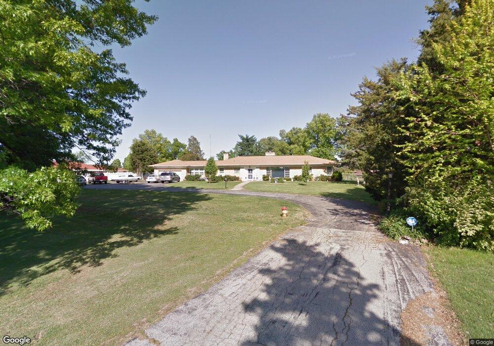
11901 Rosalind Ct Saint Louis, MO 63128
Estimated Value: $508,000 - $592,000
3
Beds
2
Baths
2,628
Sq Ft
$209/Sq Ft
Est. Value
About This Home
This home is located at 11901 Rosalind Ct, Saint Louis, MO 63128 and is currently estimated at $548,033, approximately $208 per square foot. 11901 Rosalind Ct is a home located in St. Louis County with nearby schools including Concord Elementary School, Sperreng Middle School, and Lindbergh High School.
Ownership History
Date
Name
Owned For
Owner Type
Purchase Details
Closed on
Jan 14, 2000
Sold by
Plumb John D and Plumb Carol Gay
Bought by
Rainbow Properties Inc
Current Estimated Value
Purchase Details
Closed on
Dec 30, 1999
Sold by
Manglis Tom A and Katsimanglis Arestides
Bought by
Haefner Richard and Suellentrop Marilyn R
Create a Home Valuation Report for This Property
The Home Valuation Report is an in-depth analysis detailing your home's value as well as a comparison with similar homes in the area
Home Values in the Area
Average Home Value in this Area
Purchase History
| Date | Buyer | Sale Price | Title Company |
|---|---|---|---|
| Rainbow Properties Inc | -- | -- | |
| Haefner Richard | $255,000 | Title Associates Inc | |
| Manglis Tom A | -- | Title Associates Inc | |
| Manglis Tom A | -- | Title Associates Inc |
Source: Public Records
Tax History Compared to Growth
Tax History
| Year | Tax Paid | Tax Assessment Tax Assessment Total Assessment is a certain percentage of the fair market value that is determined by local assessors to be the total taxable value of land and additions on the property. | Land | Improvement |
|---|---|---|---|---|
| 2025 | $5,460 | $110,890 | $31,750 | $79,140 |
| 2024 | $5,460 | $83,960 | $31,750 | $52,210 |
| 2023 | $5,446 | $83,960 | $31,750 | $52,210 |
| 2022 | $5,434 | $80,410 | $31,750 | $48,660 |
| 2021 | $5,241 | $80,410 | $31,750 | $48,660 |
| 2020 | $4,789 | $70,890 | $20,160 | $50,730 |
| 2019 | $4,777 | $70,890 | $20,160 | $50,730 |
| 2018 | $5,058 | $68,270 | $12,900 | $55,370 |
| 2017 | $5,002 | $68,270 | $12,900 | $55,370 |
| 2016 | $4,632 | $60,020 | $12,900 | $47,120 |
| 2015 | $4,562 | $60,020 | $12,900 | $47,120 |
| 2014 | $4,968 | $64,740 | $15,490 | $49,250 |
Source: Public Records
Map
Nearby Homes
- 10000 Hilltop Dr
- 9918 Benbury Ct Unit 1D
- 10755 Kennerly Rd
- 20 Oleander Dr
- 12224 Bird Haven Ln
- 9448 Parklind Dr
- 9411 Gates Manor Ct
- 9404 Gates Manor Ct
- 4328 S Lindbergh Blvd
- 10627 Leebur Dr
- 10508 Stephenson Dr
- 10652 Roanna Ln
- 10315 Kennerly Rd
- 10727 Roxanna Dr
- 0 Unknown Unit MIS25071866
- 0 Unknown Unit MIS25071884
- 10124 Carolynne Dr
- 10573 Carroll Wood Way
- 10525 Carroll Wood Way
- 10610 Deerpath Acres Ct
- 11922 Lockhaven Place
- 11919 Cresthaven Ct
- 11943 Lombardy Ln
- 11910 Lockhaven Place
- 11939 Lombardy Ln
- 11915 Rosalind Ct
- 11951 Lombardy Ln
- 11932 Lockhaven Place
- 11911 Cresthaven Ct
- 11918 Cresthaven Ct
- 11955 Lombardy Ln
- 11923 Lockhaven Place
- 11904 Lockhaven Place
- 11909 Lockhaven Place
- 11901 Cresthaven Ct
- 11944 Lombardy Ln
- 9817 Crestwick Dr
- 11940 Lockhaven Place
- 11948 Lombardy Ln
- 11946 Gravois Rd