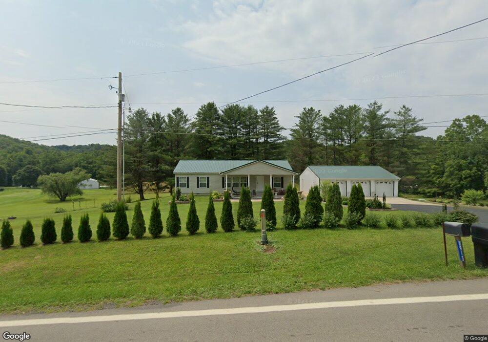
11908 State Route 691 Nelsonville, OH 45764
Estimated Value: $215,000 - $278,000
3
Beds
2
Baths
1,404
Sq Ft
$175/Sq Ft
Est. Value
About This Home
This home is located at 11908 State Route 691, Nelsonville, OH 45764 and is currently estimated at $245,659, approximately $174 per square foot. 11908 State Route 691 is a home with nearby schools including Nelsonville-York Elementary School, Nelsonville-York Junior High School, and Nelsonville-York High School.
Ownership History
Date
Name
Owned For
Owner Type
Purchase Details
Closed on
Apr 2, 2017
Sold by
Mace Brenda K
Bought by
Kish Vincent J and Kish Genalyn
Current Estimated Value
Purchase Details
Closed on
Jul 20, 2005
Sold by
Stover Rebecca
Bought by
Mace Steven and Mace Breneda K
Purchase Details
Closed on
Nov 14, 2000
Sold by
Stover Clairus J
Bought by
Stover Rebecca A
Purchase Details
Closed on
Feb 8, 1993
Sold by
Murphy Audrey
Bought by
Stover Clairus J
Create a Home Valuation Report for This Property
The Home Valuation Report is an in-depth analysis detailing your home's value as well as a comparison with similar homes in the area
Home Values in the Area
Average Home Value in this Area
Purchase History
| Date | Buyer | Sale Price | Title Company |
|---|---|---|---|
| Kish Vincent J | -- | Attorney | |
| Mace Steven | $10,000 | None Available | |
| Stover Rebecca A | -- | -- | |
| Stover Clairus J | -- | -- |
Source: Public Records
Tax History Compared to Growth
Tax History
| Year | Tax Paid | Tax Assessment Tax Assessment Total Assessment is a certain percentage of the fair market value that is determined by local assessors to be the total taxable value of land and additions on the property. | Land | Improvement |
|---|---|---|---|---|
| 2024 | $1,976 | $56,050 | $7,480 | $48,570 |
| 2023 | $1,949 | $56,050 | $7,480 | $48,570 |
| 2022 | $1,693 | $46,620 | $6,240 | $40,380 |
| 2021 | $1,699 | $46,620 | $6,240 | $40,380 |
| 2020 | $2,005 | $46,620 | $6,240 | $40,380 |
| 2019 | $1,917 | $42,610 | $5,300 | $37,310 |
| 2018 | $1,783 | $39,710 | $5,300 | $34,410 |
| 2017 | $335 | $4,630 | $4,630 | $0 |
| 2016 | $200 | $4,210 | $4,210 | $0 |
| 2015 | $301 | $4,210 | $4,210 | $0 |
| 2014 | $301 | $4,210 | $4,210 | $0 |
| 2013 | $272 | $3,960 | $3,960 | $0 |
Source: Public Records
Map
Nearby Homes
- 11685 State Route 691
- 6559 Poston Rd
- 5910 Vore Ridge Rd
- 0 Lemaster Rd
- 0 Lemaster Rd Unit 23368524
- 0 Lemaster Rd Unit 11486521
- 12981 Spice Lick Rd
- 10775 Rosewood Ln
- 4624 Rhoric Rd
- 11250 Grass Run Rd
- 0 Salem Rd
- 11676 Channingway Blvd
- 14946 Ohio 691
- 90 Main St
- 0 Shady Ln
- 27 North St
- 57 Ohio Ave
- 5 Oak St
- 7 W 2nd St
- 10313 Porter Ln
- 11915 State Route 691
- 11920 State Route 691
- 11920 State Route 691
- 11895 State Route 691
- 11933 State Route 691
- 11919 State Route 691
- 11945 State Route 691
- 11936 State Route 691
- 11936 State Route 691
- 4744 Perry Ridge
- 11960 State Route 691
- 11968 State Route 691
- 4550 Perry Ridge
- 11976 State Route 691
- 11980 State Route 691
- 11985 State Route 691
- 4536 Perry Ridge
- 11811 State Route 691
- 4573 Perry Ridge
- 4599 Perry Ridge Rd