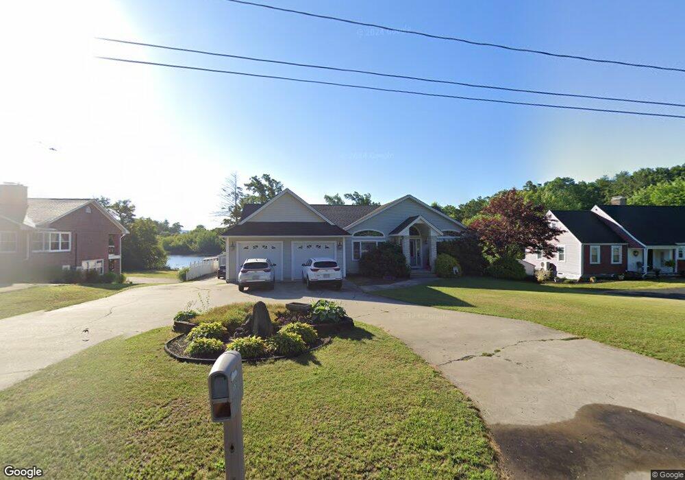
1191 S Branch Pkwy Springfield, MA 01129
Sixteen Acres NeighborhoodEstimated Value: $607,000 - $762,000
5
Beds
3
Baths
4,400
Sq Ft
$151/Sq Ft
Est. Value
About This Home
This home is located at 1191 S Branch Pkwy, Springfield, MA 01129 and is currently estimated at $665,778, approximately $151 per square foot. 1191 S Branch Pkwy is a home located in Hampden County with nearby schools including Glickman Elementary, M Marcus Kiley Middle, and Springfield High School of Science and Technology.
Ownership History
Date
Name
Owned For
Owner Type
Purchase Details
Closed on
Jan 11, 2011
Sold by
Methe Ronald and Methe Laurie A
Bought by
Perla Joseph J and Perla Victoria M
Current Estimated Value
Home Financials for this Owner
Home Financials are based on the most recent Mortgage that was taken out on this home.
Original Mortgage
$328,500
Outstanding Balance
$219,013
Interest Rate
4.4%
Mortgage Type
Purchase Money Mortgage
Estimated Equity
$446,765
Purchase Details
Closed on
Apr 29, 2004
Sold by
Roy Ernest J
Bought by
Methe Laurie A
Purchase Details
Closed on
Aug 1, 2001
Sold by
Dale William G
Bought by
Roy Ernest J
Create a Home Valuation Report for This Property
The Home Valuation Report is an in-depth analysis detailing your home's value as well as a comparison with similar homes in the area
Home Values in the Area
Average Home Value in this Area
Purchase History
| Date | Buyer | Sale Price | Title Company |
|---|---|---|---|
| Perla Joseph J | $365,000 | -- | |
| Methe Laurie A | $60,900 | -- | |
| Roy Ernest J | $50,000 | -- |
Source: Public Records
Mortgage History
| Date | Status | Borrower | Loan Amount |
|---|---|---|---|
| Open | Perla Joseph J | $328,500 |
Source: Public Records
Tax History Compared to Growth
Tax History
| Year | Tax Paid | Tax Assessment Tax Assessment Total Assessment is a certain percentage of the fair market value that is determined by local assessors to be the total taxable value of land and additions on the property. | Land | Improvement |
|---|---|---|---|---|
| 2025 | $8,790 | $560,600 | $89,000 | $471,600 |
| 2024 | $8,706 | $542,100 | $89,000 | $453,100 |
| 2023 | $8,157 | $478,400 | $84,800 | $393,600 |
| 2022 | $7,641 | $406,000 | $88,300 | $317,700 |
| 2021 | $7,167 | $379,200 | $80,300 | $298,900 |
| 2020 | $6,871 | $351,800 | $80,300 | $271,500 |
| 2019 | $7,071 | $359,300 | $80,300 | $279,000 |
| 2018 | $6,923 | $351,800 | $80,300 | $271,500 |
| 2017 | $6,069 | $308,700 | $64,200 | $244,500 |
| 2016 | $5,817 | $295,900 | $64,200 | $231,700 |
| 2015 | $5,978 | $303,900 | $64,200 | $239,700 |
Source: Public Records
Map
Nearby Homes
- 31 Acrebrook Rd
- 1454 S Branch Pkwy
- 10 Woodcrest Rd
- 114 Brookside Cir
- 1680 Parker St
- 128 Sherwood Rd
- 27 Middlebrook Dr
- 767 S Branch Pkwy
- 65 Fair Oak Rd
- 99 W Crystal Brook Dr
- 43 Birchland Ave
- 1606 Wilbraham Rd
- Lot 37 Kane St
- 1815 Parker St
- 57 Lumae St
- 60 Jeanne Marie St
- 22 Woodland Rd
- 111 Malibu Dr
- 74 Valley Rd
- 744 Bradley Rd
- 1189 S Branch Pkwy
- 1199 S Branch Pkwy
- 1229 South Branch
- 1181 S Branch Pkwy
- 1209 S Branch Pkwy
- 1229 S Branch Pkwy
- 1103 S Branch Pkwy
- 1091 S Branch Pkwy
- 1295 S Branch Pkwy
- 1281 Plumtree Rd
- 1291 Plumtree Rd
- 1303 Plumtree Rd
- 1305 S Branch Pkwy
- 1271 Plumtree Rd
- 1259 Plumtree Rd
- 1311 Plumtree Rd
- 1313 S Branch Pkwy
- 1331 Plumtree Rd
- 1321 Plumtree Rd
- 1341 Plumtree Rd