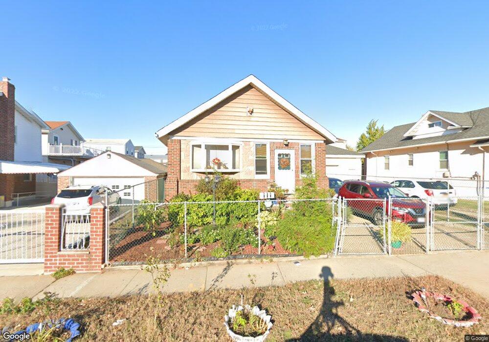
11911 N Conduit Ave South Ozone Park, NY 11420
South Ozone Park NeighborhoodEstimated Value: $647,000 - $816,000
--
Bed
--
Bath
1,040
Sq Ft
$706/Sq Ft
Est. Value
About This Home
This home is located at 11911 N Conduit Ave, South Ozone Park, NY 11420 and is currently estimated at $734,333, approximately $706 per square foot. 11911 N Conduit Ave is a home located in Queens County with nearby schools including Ps 124 Osmond A Church, J.H.S. 226 Virgil I. Grisson, and John Adams High School.
Ownership History
Date
Name
Owned For
Owner Type
Purchase Details
Closed on
Jun 10, 2014
Sold by
Denise A Graf As Trustee
Bought by
Whittington Allan A and Whittington Catherine
Current Estimated Value
Home Financials for this Owner
Home Financials are based on the most recent Mortgage that was taken out on this home.
Original Mortgage
$292,500
Outstanding Balance
$222,566
Interest Rate
4.21%
Mortgage Type
New Conventional
Estimated Equity
$511,767
Purchase Details
Closed on
Mar 31, 2009
Sold by
Graf John R and Kenney Denise
Bought by
Graf Denise and Graf John R
Create a Home Valuation Report for This Property
The Home Valuation Report is an in-depth analysis detailing your home's value as well as a comparison with similar homes in the area
Home Values in the Area
Average Home Value in this Area
Purchase History
| Date | Buyer | Sale Price | Title Company |
|---|---|---|---|
| Whittington Allan A | $325,000 | -- | |
| Graf Denise | -- | -- |
Source: Public Records
Mortgage History
| Date | Status | Borrower | Loan Amount |
|---|---|---|---|
| Open | Whittington Allan A | $292,500 |
Source: Public Records
Tax History Compared to Growth
Tax History
| Year | Tax Paid | Tax Assessment Tax Assessment Total Assessment is a certain percentage of the fair market value that is determined by local assessors to be the total taxable value of land and additions on the property. | Land | Improvement |
|---|---|---|---|---|
| 2025 | $5,666 | $31,388 | $7,280 | $24,108 |
| 2024 | $5,678 | $29,611 | $7,359 | $22,252 |
| 2023 | $5,330 | $27,936 | $6,534 | $21,402 |
| 2022 | $5,377 | $41,820 | $10,020 | $31,800 |
| 2021 | $5,539 | $34,740 | $10,020 | $24,720 |
| 2020 | $5,241 | $32,580 | $10,020 | $22,560 |
| 2019 | $4,869 | $31,260 | $10,020 | $21,240 |
| 2018 | $4,870 | $23,280 | $10,020 | $13,260 |
| 2017 | $4,747 | $23,288 | $9,972 | $13,316 |
| 2016 | $4,346 | $23,288 | $9,972 | $13,316 |
| 2015 | -- | $22,564 | $10,211 | $12,353 |
Source: Public Records
Map
Nearby Homes
- 12104 150th Ave
- 149-34 Lefferts Blvd
- 150-24 117th St
- 12114 149th Ave
- 121-14 149 Ave
- 135-28 122nd St
- 12403 152nd Ave
- 117-10 135th Ave
- 13512 122nd Place
- 124-19 152nd Ave
- 135-56 124th St
- 149-27 114th St
- 11514 135th Ave
- 135-47 124th St
- 11512 135th Ave
- 135-43 124th St
- 13344 122nd St
- 125-15 152nd Ave
- 135-42 124th St
- 126-02 150th Ave
- 11917 N Conduit Ave
- 11919 N Conduit Ave
- 15012 120th St
- 15017 Lefferts Blvd
- 15017 Lefferts Blvd
- 15013 Lefferts Blvd
- 15009 Lefferts Blvd
- 15008 120th St
- 15005 Lefferts Blvd
- 11918 150th Ave
- 150-19 120th St
- 15019 120th St
- 15001 Lefferts Blvd
- 15011 120th St
- 12002 150th Ave
- 12009 N Conduit Ave
- 12002 150th Ave
- 15016 Lefferts Blvd
- 12008 150th Ave
- 120-08 150th Ave