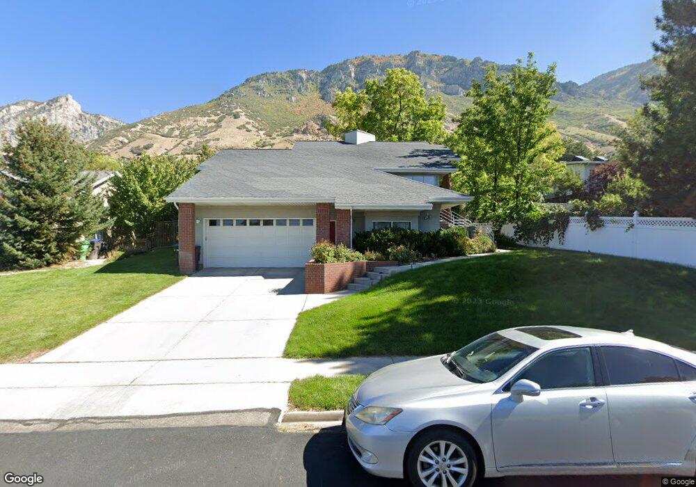
1192 N Locust Ln Provo, UT 84604
Wasatch NeighborhoodEstimated Value: $649,000 - $810,000
5
Beds
3
Baths
1,687
Sq Ft
$425/Sq Ft
Est. Value
About This Home
This home is located at 1192 N Locust Ln, Provo, UT 84604 and is currently estimated at $716,422, approximately $424 per square foot. 1192 N Locust Ln is a home with nearby schools including Wasatch Elementary School, Centennial Middle School, and Timpview High School.
Ownership History
Date
Name
Owned For
Owner Type
Purchase Details
Closed on
Jul 22, 2009
Sold by
Lynnette Ann Peterson Frost Family Prote and Frost Lynnette Ann Peterson
Bought by
Wright Matthew James and Wright Janae
Current Estimated Value
Home Financials for this Owner
Home Financials are based on the most recent Mortgage that was taken out on this home.
Original Mortgage
$263,145
Outstanding Balance
$174,172
Interest Rate
5.59%
Mortgage Type
FHA
Estimated Equity
$542,250
Create a Home Valuation Report for This Property
The Home Valuation Report is an in-depth analysis detailing your home's value as well as a comparison with similar homes in the area
Home Values in the Area
Average Home Value in this Area
Purchase History
| Date | Buyer | Sale Price | Title Company |
|---|---|---|---|
| Wright Matthew James | -- | Provo Land Title Co |
Source: Public Records
Mortgage History
| Date | Status | Borrower | Loan Amount |
|---|---|---|---|
| Open | Wright Matthew James | $263,145 |
Source: Public Records
Tax History Compared to Growth
Tax History
| Year | Tax Paid | Tax Assessment Tax Assessment Total Assessment is a certain percentage of the fair market value that is determined by local assessors to be the total taxable value of land and additions on the property. | Land | Improvement |
|---|---|---|---|---|
| 2025 | $3,163 | $359,920 | $240,900 | $413,500 |
| 2024 | $3,163 | $311,300 | $0 | $0 |
| 2023 | $2,971 | $288,310 | $0 | $0 |
| 2022 | $2,847 | $278,575 | $0 | $0 |
| 2021 | $2,316 | $395,200 | $188,100 | $207,100 |
| 2020 | $2,210 | $353,500 | $150,500 | $203,000 |
| 2019 | $2,125 | $353,500 | $150,500 | $203,000 |
| 2018 | $2,052 | $346,300 | $143,300 | $203,000 |
| 2017 | $1,915 | $177,540 | $0 | $0 |
| 2016 | $1,755 | $151,690 | $0 | $0 |
| 2015 | $1,571 | $137,225 | $0 | $0 |
| 2014 | $1,453 | $132,275 | $0 | $0 |
Source: Public Records
Map
Nearby Homes
- 1175 N Locust Ln
- 1205 N Old Willow Ln
- 1559 Oak Cliff Dr
- 943 N Terrace Dr
- 990 Cedar Ave
- 1215 N Terrace Dr
- 734 Hillsdale Ln
- 1604 N Willow Ln
- 915 E 820 N Unit 24
- 907 E 820 N Unit 11
- 617 N Seven Peaks Blvd Unit 10
- 635 N Ridge Dr Unit 25
- 1754 N 1550 E
- 788 N 700 E Unit 4
- 611 N 700 E Unit 5
- 561 N 700 E
- 1051 E 300 N
- 541 E 500 N Unit 10
- 541 E 500 N Unit 12
- 615 E 420 N
- 1204 Locust Ln
- 1355 Apple Ave
- 1375 Apple Ave
- 1220 Locust Ln
- 1191 Locust Ln
- 1393 Apple Ave
- 1211 Old Willow Ln
- 1209 Locust Ln
- 1209 N Locust Ln
- 1115 N Locust Ln
- 1115 Locust Ln
- 1230 Locust Ln
- 1225 Locust Ln
- 1225 N Locust Ln
- 1170 Holly Cir
- 1154 Holly Cir
- 1204 Old Willow Ln
- 1360 Apple Ave
- 1350 Apple Ave
- 1249 Old Willow Ln