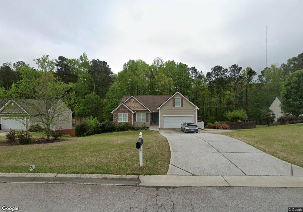
1192 Otis Dr Bethlehem, GA 30620
Estimated Value: $358,000 - $376,000
4
Beds
3
Baths
1,804
Sq Ft
$204/Sq Ft
Est. Value
About This Home
This home is located at 1192 Otis Dr, Bethlehem, GA 30620 and is currently estimated at $368,259, approximately $204 per square foot. 1192 Otis Dr is a home located in Barrow County with nearby schools including Yargo Elementary School, Haymon-Morris Middle School, and Apalachee High School.
Ownership History
Date
Name
Owned For
Owner Type
Purchase Details
Closed on
Aug 28, 2011
Sold by
Crm Central Properties Llc
Bought by
Richardson Timothy James and Richardson Julie Buhrman
Current Estimated Value
Home Financials for this Owner
Home Financials are based on the most recent Mortgage that was taken out on this home.
Original Mortgage
$110,037
Outstanding Balance
$75,747
Interest Rate
4.37%
Mortgage Type
FHA
Estimated Equity
$292,512
Purchase Details
Closed on
Jun 6, 2011
Sold by
Crown Park Hms Dh Of Cambridge
Bought by
Crm Central Properties Llc
Purchase Details
Closed on
Jun 11, 2004
Sold by
Millstone Development Group In
Bought by
Crown Park Homes At
Purchase Details
Closed on
Apr 1, 2004
Bought by
Millstone Development Group Inc
Create a Home Valuation Report for This Property
The Home Valuation Report is an in-depth analysis detailing your home's value as well as a comparison with similar homes in the area
Home Values in the Area
Average Home Value in this Area
Purchase History
| Date | Buyer | Sale Price | Title Company |
|---|---|---|---|
| Richardson Timothy James | $112,900 | -- | |
| Crm Central Properties Llc | -- | -- | |
| Crown Park Homes At | $38,500 | -- | |
| Millstone Development Group Inc | -- | -- |
Source: Public Records
Mortgage History
| Date | Status | Borrower | Loan Amount |
|---|---|---|---|
| Open | Richardson Timothy James | $110,037 |
Source: Public Records
Tax History Compared to Growth
Tax History
| Year | Tax Paid | Tax Assessment Tax Assessment Total Assessment is a certain percentage of the fair market value that is determined by local assessors to be the total taxable value of land and additions on the property. | Land | Improvement |
|---|---|---|---|---|
| 2024 | $3,639 | $145,089 | $28,000 | $117,089 |
| 2023 | $3,430 | $136,816 | $28,000 | $108,816 |
| 2022 | $2,968 | $101,390 | $22,400 | $78,990 |
| 2021 | $2,603 | $83,440 | $18,000 | $65,440 |
| 2020 | $2,446 | $78,020 | $18,000 | $60,020 |
| 2019 | $2,489 | $78,020 | $18,000 | $60,020 |
| 2018 | $2,349 | $74,220 | $14,200 | $60,020 |
| 2017 | $1,874 | $64,359 | $14,200 | $50,159 |
| 2016 | $1,781 | $56,035 | $14,200 | $41,835 |
| 2015 | $1,803 | $56,476 | $14,200 | $42,276 |
| 2014 | $1,676 | $50,557 | $7,840 | $42,717 |
| 2013 | -- | $47,396 | $7,840 | $39,556 |
Source: Public Records
Map
Nearby Homes
- 704 Newnham Walk
- 1164 Otis Dr
- 1024 Lyndhurst Ln
- 73 Silverleaf Trail
- 268 Silverleaf Trail
- 280 Silverleaf Trail
- 64 Silverleaf Trail
- 1529 Blakewood Trail
- 117 Kensington Trace
- Lancaster Plan at The Estates at Casteel
- Buckley Plan at The Estates at Casteel
- Cardiff Plan at The Estates at Casteel
- Pearson Plan at The Estates at Casteel
- Savoy Plan at The Estates at Casteel
- Hampstead Plan at The Estates at Casteel
- Pembroke Plan at The Estates at Casteel
- 362 Silverleaf Trail
- 294 Silverleaf Trail
- 934 Beaver Hill Dr
- 1129 Loganville Hwy
- 1192 Otis Dr
- 1190 Otis Dr
- 1194 Otis Dr
- 1191 Otis Dr
- 1188 Otis Dr
- 1196 Otis Dr
- 1186 Otis Dr
- 701 Newnham Walk
- 1184 Otis Dr
- 0 Newnham Walk Unit 8644714
- 708 Newnham Walk
- 703 Newnham Walk
- 1185 Otis Dr
- 1182 Otis Dr
- 710 Newnham Walk
- 636 Saddle Ridge Dr
- 634 Saddle Ridge Dr
- 632 Saddle Ridge Dr
- 632 Saddle Ridge Dr Unit 87
- 705 Newnham Walk Unit 2