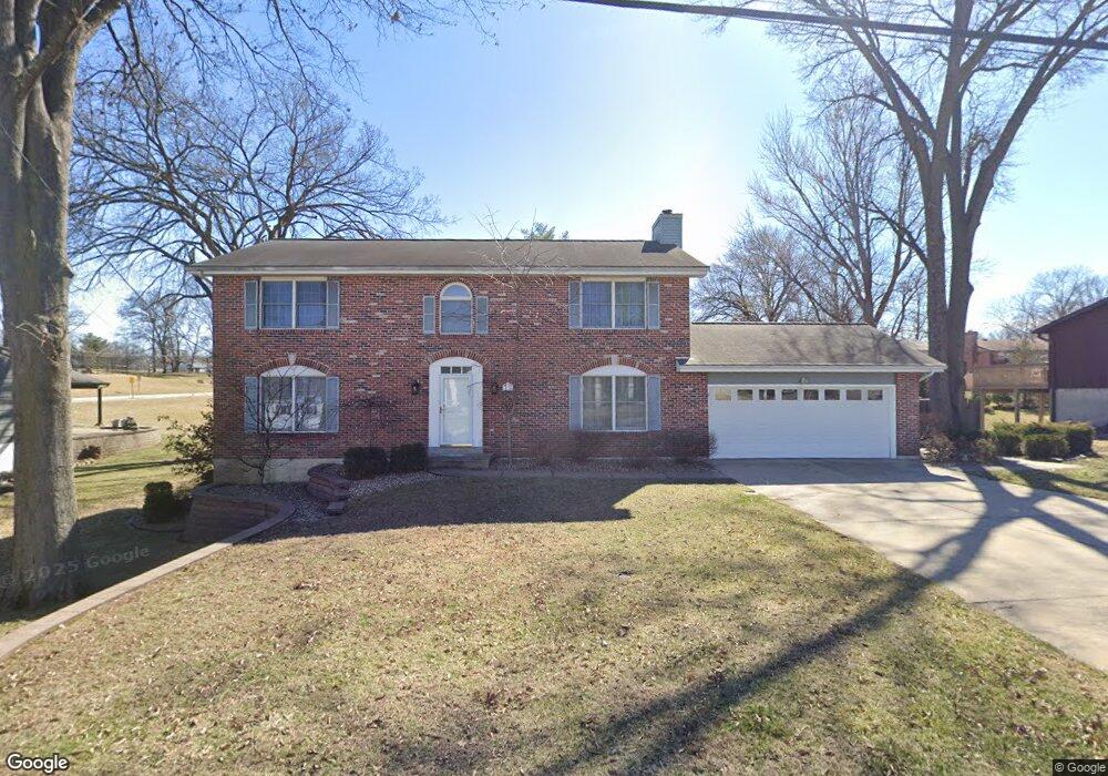
11924 Devonshire Ave Saint Louis, MO 63131
Estimated Value: $713,000 - $865,000
4
Beds
3
Baths
2,632
Sq Ft
$292/Sq Ft
Est. Value
About This Home
This home is located at 11924 Devonshire Ave, Saint Louis, MO 63131 and is currently estimated at $768,843, approximately $292 per square foot. 11924 Devonshire Ave is a home located in St. Louis County with nearby schools including Westchester Elementary School, North Kirkwood Middle School, and Kirkwood Senior High School.
Ownership History
Date
Name
Owned For
Owner Type
Purchase Details
Closed on
Oct 29, 1997
Sold by
Huber Harold C and Wynne Barbara J
Bought by
Huber Harold C and Wynne Barbara J
Current Estimated Value
Purchase Details
Closed on
Jul 11, 1997
Sold by
Winkeler Albert W and Winkeler Barbara J
Bought by
Wynne Barbara J and Huber Harold C
Home Financials for this Owner
Home Financials are based on the most recent Mortgage that was taken out on this home.
Original Mortgage
$164,000
Outstanding Balance
$20,436
Interest Rate
6%
Estimated Equity
$748,407
Create a Home Valuation Report for This Property
The Home Valuation Report is an in-depth analysis detailing your home's value as well as a comparison with similar homes in the area
Home Values in the Area
Average Home Value in this Area
Purchase History
| Date | Buyer | Sale Price | Title Company |
|---|---|---|---|
| Huber Harold C | -- | -- | |
| Wynne Barbara J | -- | -- |
Source: Public Records
Mortgage History
| Date | Status | Borrower | Loan Amount |
|---|---|---|---|
| Open | Wynne Barbara J | $164,000 |
Source: Public Records
Tax History Compared to Growth
Tax History
| Year | Tax Paid | Tax Assessment Tax Assessment Total Assessment is a certain percentage of the fair market value that is determined by local assessors to be the total taxable value of land and additions on the property. | Land | Improvement |
|---|---|---|---|---|
| 2025 | $6,368 | $106,780 | $57,300 | $49,480 |
| 2024 | $6,368 | $110,090 | $42,980 | $67,110 |
| 2023 | $6,269 | $110,090 | $42,980 | $67,110 |
| 2022 | $5,803 | $94,960 | $42,980 | $51,980 |
| 2021 | $5,741 | $94,960 | $42,980 | $51,980 |
| 2020 | $5,763 | $91,660 | $42,830 | $48,830 |
| 2019 | $5,771 | $91,660 | $42,830 | $48,830 |
| 2018 | $5,288 | $75,340 | $26,660 | $48,680 |
| 2017 | $5,302 | $75,340 | $26,660 | $48,680 |
| 2016 | $4,805 | $69,120 | $19,040 | $50,080 |
| 2015 | $4,811 | $69,120 | $19,040 | $50,080 |
| 2014 | $4,482 | $62,910 | $9,960 | $52,950 |
Source: Public Records
Map
Nearby Homes
- 11913 Lillian Ave
- 11909 Lillian Ave
- 1090 Kinstern Dr
- 896 Twin Pine Dr
- 919 Nana Ln
- 1422 Northlin Dr
- 1126 Bopp Rd
- 1710 Lynkirk Ln
- 1001 Dovergate Dr
- 918 N Ballas Rd
- 946 Rochdale Dr
- 811 Cherry St
- 785 N Ballas Rd
- 715 Westchester Ct
- 11358 Manchester Rd
- 1312 W Essex Ave
- 2037 Trailcrest Ln Unit 7
- 2005 Woodland Knoll
- 2017 Woodland Knoll
- 2002 Woodland Knoll
- 995 Tallie Dr
- 11930 Devonshire Ave
- 11931 Amherst Dr
- 11919 Devonshire Ave
- 11927 Amherst Dr
- 11923 Devonshire Ave
- 11925 Devonshire Ave
- 11935 Amherst Dr
- 11940 Devonshire Ave
- 1003 Tallie Dr
- 11929 Devonshire Ave
- 11939 Amherst Dr
- 11848 Devonshire Ave
- 11931 Devonshire Ave
- 11942 Devonshire Ave
- 11849 Devonshire Ave
- 11943 Amherst Dr
- 11928 Amherst Dr
- 11906 Manhattan Ave
- 11902 Manhattan Ave