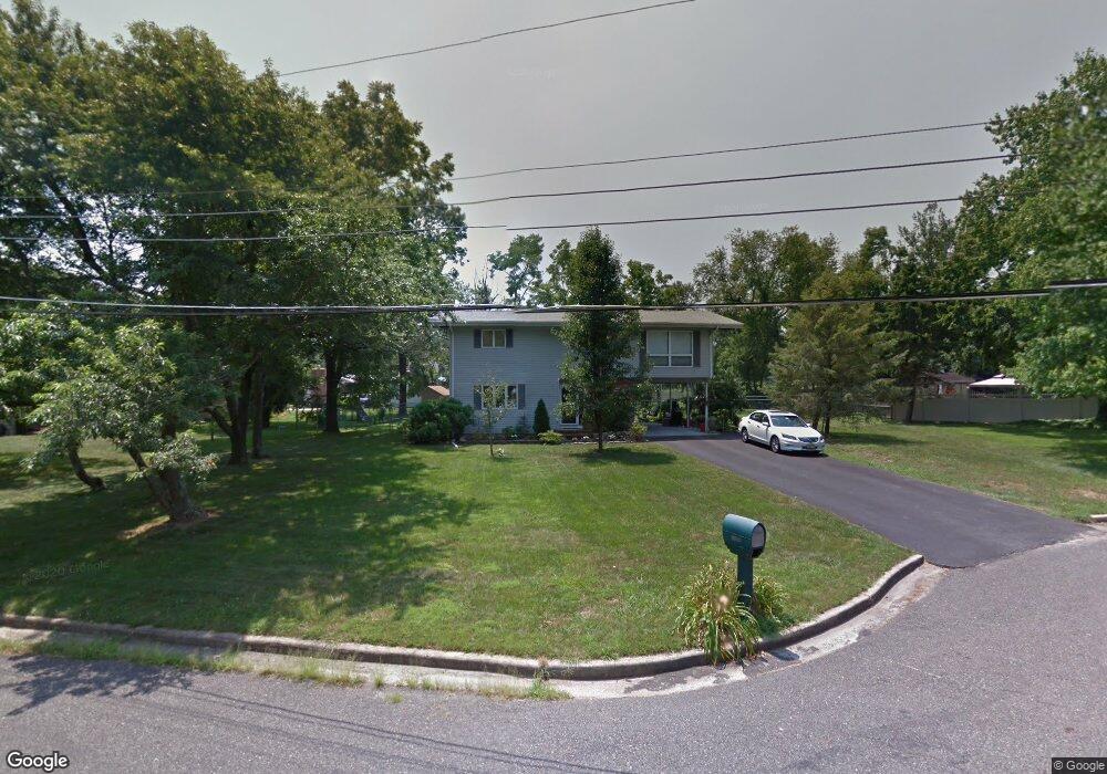
1193 Temm Ct Vineland, NJ 08360
Estimated Value: $312,000 - $388,000
--
Bed
--
Bath
1,849
Sq Ft
$190/Sq Ft
Est. Value
About This Home
This home is located at 1193 Temm Ct, Vineland, NJ 08360 and is currently estimated at $352,047, approximately $190 per square foot. 1193 Temm Ct is a home located in Cumberland County with nearby schools including Marie D. Durand Elementary School, T.W. Wallace Middle School, and Vineland Senior High School.
Ownership History
Date
Name
Owned For
Owner Type
Purchase Details
Closed on
Jun 12, 2009
Sold by
Dondero Jablonski Mary and Jablonski Mary T
Bought by
Jablonski Robert J and Jablonski Mary T
Current Estimated Value
Purchase Details
Closed on
Jun 28, 2002
Sold by
Stiteler James
Bought by
Jablonski Mary
Home Financials for this Owner
Home Financials are based on the most recent Mortgage that was taken out on this home.
Original Mortgage
$50,000
Interest Rate
6.92%
Create a Home Valuation Report for This Property
The Home Valuation Report is an in-depth analysis detailing your home's value as well as a comparison with similar homes in the area
Home Values in the Area
Average Home Value in this Area
Purchase History
| Date | Buyer | Sale Price | Title Company |
|---|---|---|---|
| Jablonski Robert J | -- | -- | |
| Jablonski Mary | $140,500 | -- |
Source: Public Records
Mortgage History
| Date | Status | Borrower | Loan Amount |
|---|---|---|---|
| Previous Owner | Jablonski Mary | $50,000 |
Source: Public Records
Tax History Compared to Growth
Tax History
| Year | Tax Paid | Tax Assessment Tax Assessment Total Assessment is a certain percentage of the fair market value that is determined by local assessors to be the total taxable value of land and additions on the property. | Land | Improvement |
|---|---|---|---|---|
| 2025 | $5,480 | $172,100 | $38,500 | $133,600 |
| 2024 | $5,480 | $172,100 | $38,500 | $133,600 |
| 2023 | $5,444 | $172,100 | $38,500 | $133,600 |
| 2022 | $5,282 | $172,100 | $38,500 | $133,600 |
| 2021 | $5,185 | $172,100 | $38,500 | $133,600 |
| 2020 | $5,037 | $172,100 | $38,500 | $133,600 |
| 2019 | $4,969 | $172,100 | $38,500 | $133,600 |
| 2018 | $4,838 | $172,100 | $38,500 | $133,600 |
| 2017 | $4,595 | $172,100 | $38,500 | $133,600 |
| 2016 | $4,433 | $172,100 | $38,500 | $133,600 |
| 2015 | $4,270 | $172,100 | $38,500 | $133,600 |
| 2014 | $4,037 | $172,100 | $38,500 | $133,600 |
Source: Public Records
Map
Nearby Homes
- 3397 N Delsea Dr
- 3332 N Delsea Dr
- 1107 W Weymouth Rd
- 2851 Nicolette Ct
- 4191 Lake Rd Unit 5
- 4191 Lake Rd Unit 9
- 4111 N Delsea Dr Unit 3
- 4111 N Delsea Dr Unit 11
- 733 W Forest Grove Rd
- 659 W Forest Grove Rd
- 1245 Old Lake Rd
- 1301 Old Lake Rd
- 829 W Garden Rd
- 811 W Garden Rd
- 3431 N East Blvd
- 3014 N West Blvd
- 14 Sandy Dr
- 9 Southeast Blvd
- 2246 N West Ave
- 4241 Robert Dr
- 3384 Burnt Mill Dr
- 1221 Temm Ct
- 3362 Burnt Mill Dr
- 1194 Temm Ct
- 1214 Temm Ct
- 3422 Burnt Mill Dr
- 3350 Burnt Mill Dr
- 3377 N Delsea Dr
- 3383 Burnt Mill Dr
- 3339 N Delsea Dr
- 3369 Burnt Mill Dr
- 3403 Burnt Mill Dr
- 3413 N Delsea Dr
- 1247 Regina Elena Ave
- 3452 Burnt Mill Dr
- 3330 Burnt Mill Dr
- 3321 N Delsea Dr
- 1169 Regina Elena Ave
- 3427 N Delsea Dr
- 3339 Burnt Mill Dr