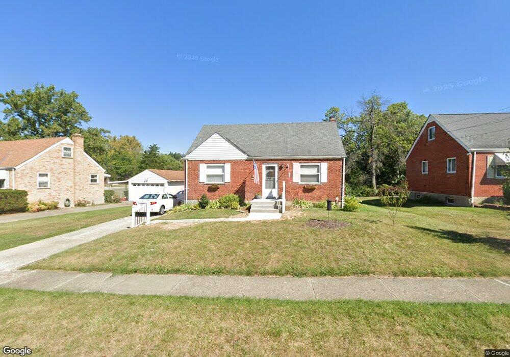
1194 Madeleine Cir Cincinnati, OH 45231
Finneytown NeighborhoodEstimated Value: $184,000 - $224,000
4
Beds
1
Bath
1,329
Sq Ft
$156/Sq Ft
Est. Value
About This Home
This home is located at 1194 Madeleine Cir, Cincinnati, OH 45231 and is currently estimated at $207,306, approximately $155 per square foot. 1194 Madeleine Cir is a home located in Hamilton County with nearby schools including Mt Healthy High School, John Paul II Catholic School, and St. Vivian School.
Ownership History
Date
Name
Owned For
Owner Type
Purchase Details
Closed on
Apr 2, 2012
Sold by
Koehne Kimberly A and Koehne Timothy J
Bought by
Koehne Timothy J and Koehne Kimberly A
Current Estimated Value
Purchase Details
Closed on
Aug 29, 2006
Sold by
Collins Kim and Collins Daniel
Bought by
Leta Billie Jean
Purchase Details
Closed on
May 29, 1998
Sold by
Salamone Janet and Monterosso Janet
Bought by
Strobl Kimberly A
Create a Home Valuation Report for This Property
The Home Valuation Report is an in-depth analysis detailing your home's value as well as a comparison with similar homes in the area
Home Values in the Area
Average Home Value in this Area
Purchase History
We collect this data history from publicly available records. To have your information removed, we recommend requesting removal directly through your county’s website.
| Date | Buyer | Sale Price | Title Company |
|---|---|---|---|
| Koehne Timothy J | -- | Attorney | |
| Leta Billie Jean | $60,000 | None Available | |
| Strobl Kimberly A | $78,000 | -- |
Source: Public Records
Tax History
| Year | Tax Paid | Tax Assessment Tax Assessment Total Assessment is a certain percentage of the fair market value that is determined by local assessors to be the total taxable value of land and additions on the property. | Land | Improvement |
|---|---|---|---|---|
| 2025 | $3,466 | $49,592 | $12,058 | $37,534 |
| 2024 | $3,386 | $49,592 | $12,058 | $37,534 |
| 2023 | $3,329 | $49,592 | $12,058 | $37,534 |
| 2022 | $2,942 | $31,773 | $11,900 | $19,873 |
| 2021 | $2,886 | $31,773 | $11,900 | $19,873 |
| 2020 | $2,933 | $31,773 | $11,900 | $19,873 |
| 2019 | $2,693 | $26,926 | $10,084 | $16,842 |
| 2018 | $2,487 | $26,926 | $10,084 | $16,842 |
| 2017 | $2,370 | $26,926 | $10,084 | $16,842 |
| 2016 | $2,488 | $27,787 | $10,413 | $17,374 |
| 2015 | $2,504 | $27,787 | $10,413 | $17,374 |
| 2014 | $2,506 | $27,787 | $10,413 | $17,374 |
| 2013 | $2,552 | $29,250 | $10,962 | $18,288 |
Source: Public Records
Map
Nearby Homes
- 1176 Madeleine Cir
- 1175 Madeleine Cir
- 8877 Balboa Dr
- 8779 Daly Rd
- 8796 Balboa Dr
- 8793 Balboa Dr
- 8754 Monsanto Dr
- 1149 Madeleine Cir
- 1101 Meadowind Ct
- 8819 Grenada Dr
- 1116 Madeleine Cir
- 8668 Daly Rd
- 1275 Frost Ct
- 8844 Ebro Ct
- 1290 Aldrich Ave
- 8845 Ebro Ct
- 1284 Compton Rd
- 1304 Aldrich Ave
- 8634 Daly Rd
- 1107 Compton Rd
- 1190 Madeleine Cir
- 1198 Madeleine Cir
- 8906 Daly Rd
- 1186 Madeleine Cir
- 8893 Monsanto Dr
- 8914 Daly Rd
- 8899 Monsanto Dr
- 8860 Daly Rd
- 1191 Madeleine Cir
- 1195 Madeleine Cir
- 1187 Madeleine Cir
- 8920 Daly Rd
- 8895 Daly Rd
- 8883 Daly Rd
- 8852 Daly Rd
- 8903 Monsanto Dr
- 8905 Daly Rd
- 8928 Daly Rd
- 8853 Monsanto Dr
- 8844 Daly Rd
Your Personal Tour Guide
Ask me questions while you tour the home.