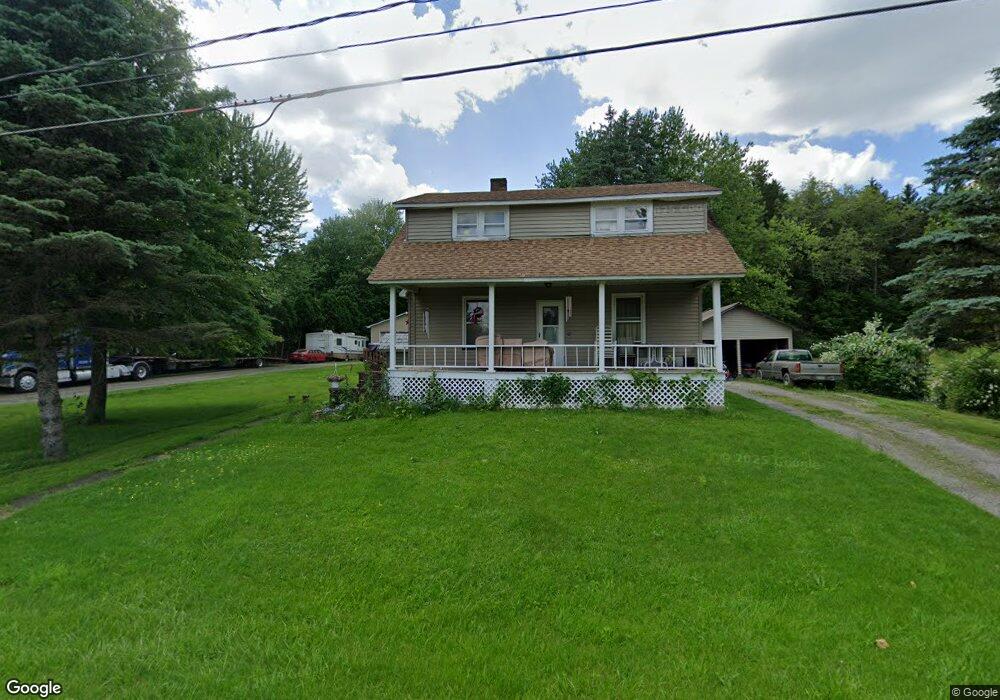
11940 New Buffalo Rd North Lima, OH 44452
Estimated Value: $160,880 - $227,000
2
Beds
1
Bath
1,433
Sq Ft
$137/Sq Ft
Est. Value
About This Home
This home is located at 11940 New Buffalo Rd, North Lima, OH 44452 and is currently estimated at $195,720, approximately $136 per square foot. 11940 New Buffalo Rd is a home located in Mahoning County with nearby schools including South Range Elementary School, South Range Middle School, and South Range High School.
Ownership History
Date
Name
Owned For
Owner Type
Purchase Details
Closed on
Oct 6, 2022
Bought by
Frank Oens
Current Estimated Value
Home Financials for this Owner
Home Financials are based on the most recent Mortgage that was taken out on this home.
Interest Rate
6.66%
Purchase Details
Closed on
Aug 31, 1984
Bought by
Oens Frank and Oens Patricia
Create a Home Valuation Report for This Property
The Home Valuation Report is an in-depth analysis detailing your home's value as well as a comparison with similar homes in the area
Home Values in the Area
Average Home Value in this Area
Purchase History
| Date | Buyer | Sale Price | Title Company |
|---|---|---|---|
| Frank Oens | -- | -- | |
| Oens Frank | -- | -- |
Source: Public Records
Mortgage History
| Date | Status | Borrower | Loan Amount |
|---|---|---|---|
| Open | Oens Frank | $138,659 | |
| Closed | Frank Oens | -- | |
| Previous Owner | Oens Frank | $122,400 | |
| Previous Owner | Oens Frank | $89,600 |
Source: Public Records
Tax History Compared to Growth
Tax History
| Year | Tax Paid | Tax Assessment Tax Assessment Total Assessment is a certain percentage of the fair market value that is determined by local assessors to be the total taxable value of land and additions on the property. | Land | Improvement |
|---|---|---|---|---|
| 2024 | $1,947 | $49,760 | $6,090 | $43,670 |
| 2023 | $1,984 | $49,760 | $6,090 | $43,670 |
| 2022 | $1,391 | $33,410 | $3,400 | $30,010 |
| 2021 | $1,408 | $33,410 | $3,400 | $30,010 |
| 2020 | $1,414 | $33,410 | $3,400 | $30,010 |
| 2019 | $1,161 | $28,410 | $3,400 | $25,010 |
| 2018 | $1,146 | $28,410 | $3,400 | $25,010 |
| 2017 | $1,143 | $28,410 | $3,400 | $25,010 |
| 2016 | $1,111 | $27,370 | $2,720 | $24,650 |
| 2015 | $1,091 | $27,370 | $2,720 | $24,650 |
| 2014 | $1,104 | $27,370 | $2,720 | $24,650 |
| 2013 | $1,094 | $27,370 | $2,720 | $24,650 |
Source: Public Records
Map
Nearby Homes
- 2680 W South Range Rd
- 3079 W South Range Rd
- 11695 Basinger Rd
- 3555 W South Range Rd
- 11400 Sharrott Rd
- 0 W Pine Lake Rd
- 11158 Detwiler Rd
- 12157 Columbiana Canfield Rd
- 11849 South Ave
- 1924 Mallard Landing
- 471 Olde Country Ln
- 13752 Columbiana Canfield Rd
- 9974 New Buffalo Rd
- 1482 Lake Front Blvd
- 1484 Lake Front Blvd
- 1486 Lake Front Blvd
- 11900 Market St
- 11356 Market St
- 11216 Market St
- 11200 Market St
- 11953 New Buffalo Rd
- 11912 New Buffalo Rd
- 2538 W South Range Rd
- 0 W South Range Rd Unit 5032414
- 0 W South Range Rd Unit 4396518
- 11855 New Buffalo Rd
- 2444 W South Range Rd
- 11868 New Buffalo Rd
- 12025 New Buffalo Rd
- 2577 W South Range Rd
- 12026 New Buffalo Rd
- 2443 W South Range Rd
- 00 S Range Rd
- 0 New Buffalo Rd Unit 3612770
- 0 New Buffalo Rd Unit 3801054
- 0 New Buffalo Rd Unit 5058838
- 0 New Buffalo Rd Unit 4345776
- 2459 W South Range Rd
- 2418 W South Range Rd
- 2612 S Range