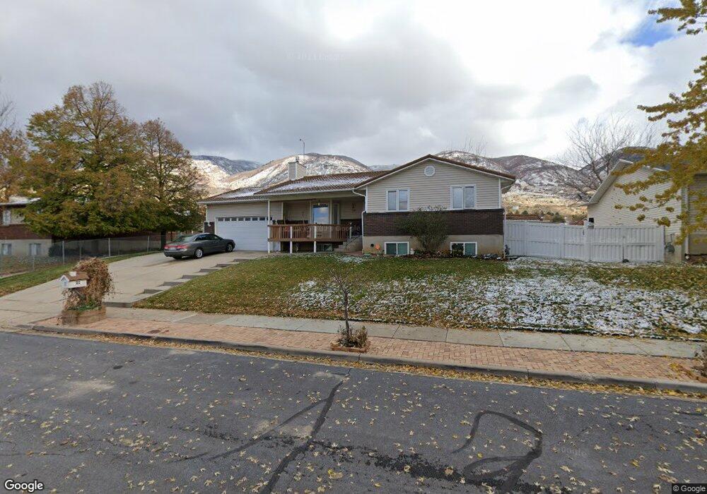
1196 N 225 W Centerville, UT 84014
Estimated Value: $541,000 - $658,000
6
Beds
3
Baths
2,944
Sq Ft
$209/Sq Ft
Est. Value
About This Home
This home is located at 1196 N 225 W, Centerville, UT 84014 and is currently estimated at $614,513, approximately $208 per square foot. 1196 N 225 W is a home located in Davis County with nearby schools including Stewart Elementary School, Centerville Jr High, and Viewmont High School.
Ownership History
Date
Name
Owned For
Owner Type
Purchase Details
Closed on
Jan 18, 2008
Sold by
Phelps David A
Bought by
Phelps David A and Moon Teresa
Current Estimated Value
Home Financials for this Owner
Home Financials are based on the most recent Mortgage that was taken out on this home.
Original Mortgage
$275,500
Outstanding Balance
$173,266
Interest Rate
6.09%
Mortgage Type
Purchase Money Mortgage
Estimated Equity
$441,247
Purchase Details
Closed on
Jan 17, 2008
Sold by
Tate Kelly H
Bought by
Phelps David A
Home Financials for this Owner
Home Financials are based on the most recent Mortgage that was taken out on this home.
Original Mortgage
$275,500
Outstanding Balance
$173,266
Interest Rate
6.09%
Mortgage Type
Purchase Money Mortgage
Estimated Equity
$441,247
Purchase Details
Closed on
Feb 2, 2004
Sold by
Tate Kelly H
Bought by
Tate Kelly H and Tate Cathy
Create a Home Valuation Report for This Property
The Home Valuation Report is an in-depth analysis detailing your home's value as well as a comparison with similar homes in the area
Purchase History
| Date | Buyer | Sale Price | Title Company |
|---|---|---|---|
| Phelps David A | -- | Founders Title Co Layton | |
| Phelps David A | -- | Integrated Title Insurance | |
| Tate Kelly H | -- | -- |
Source: Public Records
Mortgage History
| Date | Status | Borrower | Loan Amount |
|---|---|---|---|
| Open | Phelps David A | $275,500 |
Source: Public Records
Tax History
| Year | Tax Paid | Tax Assessment Tax Assessment Total Assessment is a certain percentage of the fair market value that is determined by local assessors to be the total taxable value of land and additions on the property. | Land | Improvement |
|---|---|---|---|---|
| 2025 | $3,668 | $324,500 | $160,148 | $164,352 |
| 2024 | $3,775 | $315,149 | $143,189 | $171,960 |
| 2023 | $3,598 | $298,100 | $129,727 | $168,372 |
| 2022 | $3,716 | $574,000 | $216,178 | $357,822 |
| 2021 | $3,372 | $442,000 | $180,289 | $261,711 |
| 2020 | $2,963 | $378,000 | $176,716 | $201,284 |
| 2019 | $2,872 | $371,000 | $179,271 | $191,729 |
| 2018 | $2,646 | $344,000 | $166,466 | $177,534 |
| 2016 | $2,245 | $162,855 | $52,715 | $110,140 |
| 2015 | $2,231 | $152,735 | $52,715 | $100,020 |
| 2014 | $2,113 | $147,268 | $52,715 | $94,553 |
| 2013 | -- | $146,592 | $44,204 | $102,388 |
Source: Public Records
Map
Nearby Homes
- 1238 N 450 W
- 290 W 1350 N
- 271 Brookfield Ln
- 22 Creekside Ln
- 66 Brookside Ln
- 775 Pheasantbrook Cir
- 781 Pheasantbrook Dr
- 1171 N 725 W
- 292 W 680 N
- 1021 N 740 W
- 1366 Cottonwood Dr
- 303 W 650 N Unit I
- 281 W 650 N Unit B
- 282 W 605 N Unit A
- 282 W 605 N Unit I
- 1549 N 400 W
- 493 W 620 N Unit 122
- 507 W 620 N
- 984 N 500 E
- 1290 Oakridge Dr
Your Personal Tour Guide
Ask me questions while you tour the home.