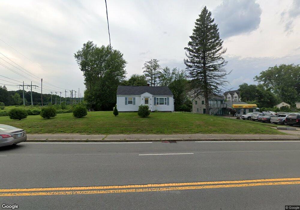
1197 Boston Rd Haverhill, MA 01835
Ward Hill NeighborhoodEstimated Value: $440,000 - $500,385
2
Beds
2
Baths
1,080
Sq Ft
$446/Sq Ft
Est. Value
About This Home
This home is located at 1197 Boston Rd, Haverhill, MA 01835 and is currently estimated at $481,596, approximately $445 per square foot. 1197 Boston Rd is a home located in Essex County with nearby schools including Greenleaf Academy, Bradford Elementary School, and Haverhill High School.
Ownership History
Date
Name
Owned For
Owner Type
Purchase Details
Closed on
Jul 22, 1988
Sold by
Brindle Richard H
Bought by
Savvas Vlaifos
Current Estimated Value
Home Financials for this Owner
Home Financials are based on the most recent Mortgage that was taken out on this home.
Original Mortgage
$100,000
Interest Rate
10.49%
Mortgage Type
Purchase Money Mortgage
Create a Home Valuation Report for This Property
The Home Valuation Report is an in-depth analysis detailing your home's value as well as a comparison with similar homes in the area
Home Values in the Area
Average Home Value in this Area
Purchase History
| Date | Buyer | Sale Price | Title Company |
|---|---|---|---|
| Savvas Vlaifos | $144,900 | -- |
Source: Public Records
Mortgage History
| Date | Status | Borrower | Loan Amount |
|---|---|---|---|
| Closed | Savvas Vlaifos | $100,000 | |
| Previous Owner | Savvas Vlaifos | $50,000 |
Source: Public Records
Tax History Compared to Growth
Tax History
| Year | Tax Paid | Tax Assessment Tax Assessment Total Assessment is a certain percentage of the fair market value that is determined by local assessors to be the total taxable value of land and additions on the property. | Land | Improvement |
|---|---|---|---|---|
| 2025 | $4,467 | $417,100 | $191,700 | $225,400 |
| 2024 | $4,184 | $393,200 | $181,100 | $212,100 |
| 2023 | $4,113 | $368,900 | $181,100 | $187,800 |
| 2022 | $4,084 | $321,100 | $170,600 | $150,500 |
| 2021 | $3,916 | $291,400 | $153,000 | $138,400 |
| 2020 | $3,963 | $291,400 | $153,000 | $138,400 |
| 2019 | $3,796 | $272,100 | $133,700 | $138,400 |
| 2018 | $3,760 | $263,700 | $133,700 | $130,000 |
| 2017 | $3,215 | $214,500 | $96,700 | $117,800 |
| 2016 | $3,164 | $206,000 | $96,700 | $109,300 |
| 2015 | $2,973 | $193,700 | $84,400 | $109,300 |
Source: Public Records
Map
Nearby Homes
- 301 Farrwood Dr
- 213 Farrwood Dr
- 406 Farrwood Dr Unit 406
- 414 Farrwood Dr Unit 414
- 107 Farrwood Dr Unit 107
- 308 Willow Ave
- 45 Christopher Dr Unit 101
- 45 Christopher Dr Unit 314
- 17 Ferry Rd
- 128 Bradford St
- 49 Ferry Rd
- 14 S Riverview St
- 29 Pitman St
- 29 Wallace St
- 812 S Main St
- 2 Goodrich Ave
- 16 Farley St
- 10 Albermarle St
- 15 Burrill Ave
- 95 Pilgrim Cir Unit 95
- 1181 Boston Rd Unit C
- 2 Cross Rd
- 2 Cross Rd Unit 3
- 2 Cross Rd Unit 5
- 2 Cross Rd Unit 6
- 2 Cross Rd Unit 4
- 2 Cross Rd Unit 2
- 2 Cross Rd Unit 1
- 2 Cross Rd Unit 7
- 2 Cross Rd Unit 8
- 2 Cross Rd Unit 10
- 2 Cross Rd Unit 9
- 1179 Boston Rd
- 31 Bradstreet Ave
- 29 Bradstreet Ave
- 1223 Boston Rd
- 1227 Boston Rd
- 1226 Boston Rd
- 319 Farrwood Dr
- 321 Farrwood Dr