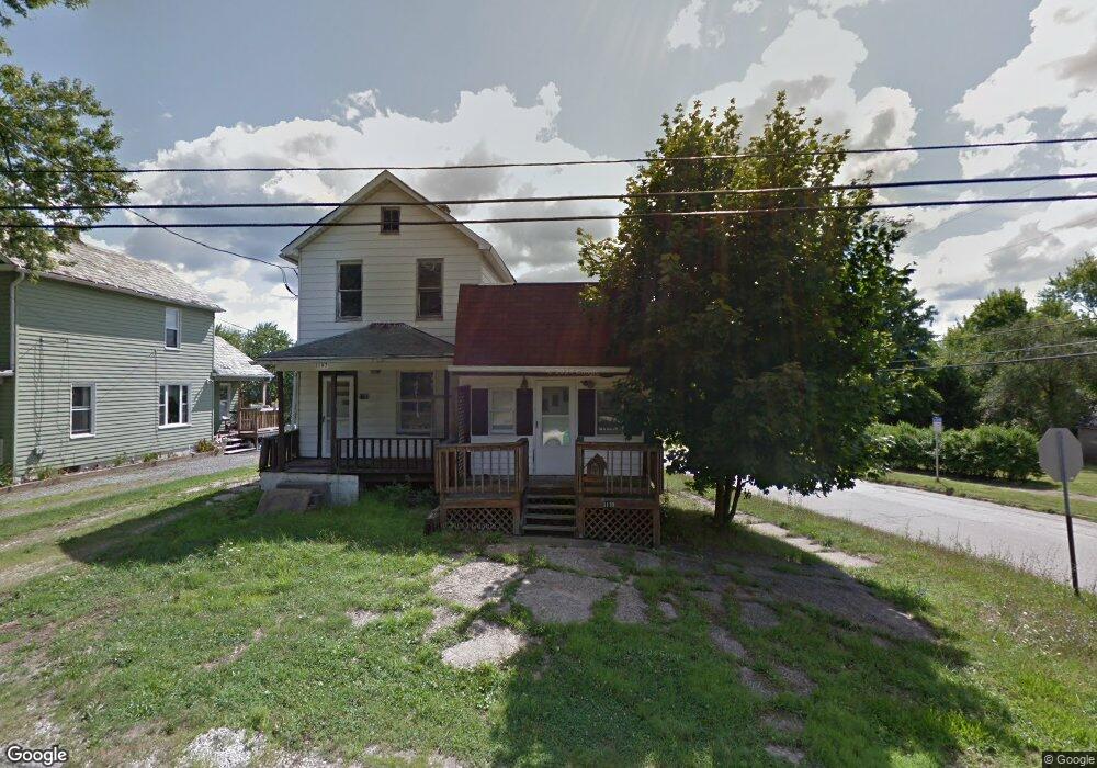
1197 Broadway St Masury, OH 44438
Estimated Value: $62,286 - $90,000
3
Beds
2
Baths
1,872
Sq Ft
$42/Sq Ft
Est. Value
About This Home
This home is located at 1197 Broadway St, Masury, OH 44438 and is currently estimated at $77,822, approximately $41 per square foot. 1197 Broadway St is a home located in Trumbull County with nearby schools including Brookfield Elementary School, Brookfield Middle School, and Brookfield High School.
Ownership History
Date
Name
Owned For
Owner Type
Purchase Details
Closed on
May 11, 2007
Sold by
First National Bank Of Pennsylvania
Bought by
Maritch Charles M and Miller Candace A
Current Estimated Value
Purchase Details
Closed on
May 7, 2007
Sold by
First National Bank Of Pennsylvania
Bought by
Maritch Charles M and Miller Candace A
Purchase Details
Closed on
Sep 26, 2006
Sold by
Mild Robert P
Bought by
First National Bank Of Pa
Purchase Details
Closed on
Jun 13, 2006
Sold by
Mild Robert P
Bought by
First National Bank Of Pa
Purchase Details
Closed on
Jan 1, 1990
Bought by
David M Bossick
Create a Home Valuation Report for This Property
The Home Valuation Report is an in-depth analysis detailing your home's value as well as a comparison with similar homes in the area
Home Values in the Area
Average Home Value in this Area
Purchase History
| Date | Buyer | Sale Price | Title Company |
|---|---|---|---|
| Maritch Charles M | $15,000 | None Available | |
| Maritch Charles M | $15,000 | None Available | |
| First National Bank Of Pa | $25,000 | None Available | |
| First National Bank Of Pa | $25,000 | None Available | |
| David M Bossick | -- | -- |
Source: Public Records
Tax History Compared to Growth
Tax History
| Year | Tax Paid | Tax Assessment Tax Assessment Total Assessment is a certain percentage of the fair market value that is determined by local assessors to be the total taxable value of land and additions on the property. | Land | Improvement |
|---|---|---|---|---|
| 2024 | $207 | $8,440 | $1,750 | $6,690 |
| 2023 | $207 | $8,440 | $1,750 | $6,690 |
| 2022 | $270 | $9,100 | $1,750 | $7,350 |
| 2021 | $254 | $9,100 | $1,750 | $7,350 |
| 2020 | $252 | $9,100 | $1,750 | $7,350 |
| 2019 | $258 | $8,680 | $1,750 | $6,930 |
| 2018 | $256 | $8,680 | $1,750 | $6,930 |
| 2017 | $255 | $8,680 | $1,750 | $6,930 |
| 2016 | $232 | $7,560 | $1,750 | $5,810 |
| 2015 | $232 | $7,560 | $1,750 | $5,810 |
| 2014 | $231 | $7,560 | $1,750 | $5,810 |
| 2013 | $219 | $8,020 | $1,750 | $6,270 |
Source: Public Records
Map
Nearby Homes
- 1354 Stevenson Rd
- 7440 Stewart Sharon Rd
- 928 Bedford Rd
- 7182 Stewart Sharon Rd
- 766 S Irvine Ave
- 545 & 625 Davis St
- 691 S Irvine Ave
- 609 Syme St
- 1952 Hubbard Masury Rd
- 365 Brookfield Ave
- 807 Lee Ave
- 306 Federal St
- 887 State Route 7 SE
- 506 Spearman Ave
- 6855 Stewart Sharon Rd
- 238 Malleable St
- 6976 White Oak Dr
- 626 Fruit Ave
- 268 Malleable St
- 1120 Wallis Ave