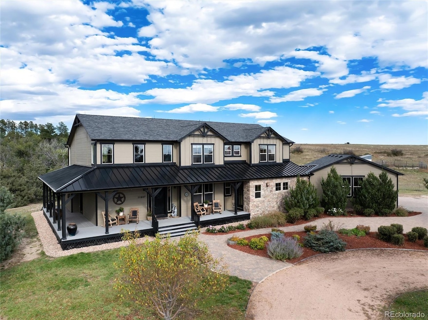
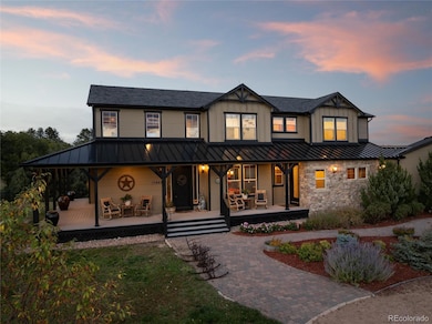
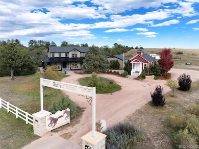
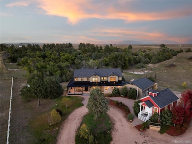
11987 Peyton Hwy Peyton, CO 80831
Estimated payment $8,114/month
Highlights
- Horses Allowed On Property
- Primary Bedroom Suite
- Open Floorplan
- Home fronts a pond
- 80 Acre Lot
- Pasture Views
About This Home
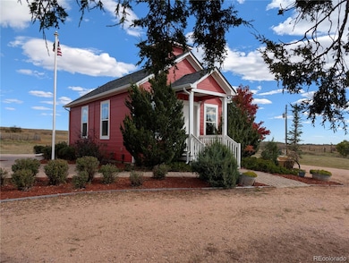
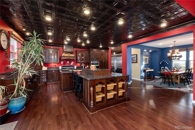
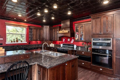
Over 125 years of love and laughter are woven into this landmark 4000 SF 6 bdrm/3 1⁄2 bath custom home and school house on 80 acres. Built to accommodate a family of 9, this legacy ranch includes multiple barns, historic grain silo, personal picnic area and pond, irrigation cistern and endless acres to explore. More than 400 trees, planted by WPA when property was first homesteaded, now create a natural forest buffer—offering privacy, shade, and a peaceful setting for picnics and fireside gatherings near the secluded pond. The memories made here are preserved in a lovingly curated scrapbook for your perusal. The home’s interior honors its western roots, blending rustic charm with modern comforts. You’ll find a stamped tin ceiling in the kitchen, dark wood cabinetry, a river rock two-story fireplace, and arched passageways—all paying homage to the Old West. The chef's kitchen can easily cater a crowd including double dishwashers, double sinks, double ovens,extensive prep area and expansive island all with granite counters. Main floor primary suite offers a cozy 2-sided fireplace, sitting area and access to the secluded deck. Each bedroom is uniquely designed with themes reflecting the western lifestyle—dressage, rodeo, and ranching—and includes thoughtful custom touches like horse stall closet doors. Upstairs Jack and Jill bath has 4 sinks and two tub/showers. The other hall bath has three sinks and separate tub/shower area for efficient shared use. The 600 SF school house with its own bath and drinking fountain offers potential as a guest cottage or second dwelling unit. Several concrete block barns originally used for a dairy operation remain with new 2023 roofs, storage rooms, grain loft, tack rooms and several run in sheds for livestock. The large grain silo is a regional landmark and is in excellent condition. The property is completely fenced and cross fenced. There is a new 75-gal water heater, new 2023 roofs (all outbuildings), and fresh exterior paint.
Listing Agent
Courtney Associates Brokerage Email: camille@camillecourtney.com,720-390-8434 License #100040486 Listed on: 10/10/2025
Home Details
Home Type
- Single Family
Est. Annual Taxes
- $2,491
Year Built
- Built in 2005 | Remodeled
Lot Details
- 80 Acre Lot
- Home fronts a pond
- Southwest Facing Home
- Property is Fully Fenced
- Landscaped
- Level Lot
- Front Yard Sprinklers
- Irrigation
- Meadow
- Partially Wooded Lot
- Many Trees
- Garden
- Grass Covered Lot
- Subdivision Possible
- Property is zoned A-35
Parking
- 2 Car Attached Garage
Property Views
- Pasture
- Mountain
Home Design
- Frame Construction
- Composition Roof
- Concrete Perimeter Foundation
Interior Spaces
- 4,023 Sq Ft Home
- 2-Story Property
- Open Floorplan
- Built-In Features
- Vaulted Ceiling
- Gas Log Fireplace
- Double Pane Windows
- Window Treatments
- Entrance Foyer
- Great Room with Fireplace
- 2 Fireplaces
- Dining Room
- Crawl Space
Kitchen
- Double Oven
- Cooktop with Range Hood
- Microwave
- Dishwasher
- Kitchen Island
- Granite Countertops
- Disposal
Flooring
- Wood
- Carpet
- Tile
Bedrooms and Bathrooms
- Fireplace in Primary Bedroom
- Primary Bedroom Suite
- Walk-In Closet
- Jack-and-Jill Bathroom
Laundry
- Laundry Room
- Dryer
- Washer
Eco-Friendly Details
- Smoke Free Home
Outdoor Features
- Wrap Around Porch
- Outdoor Water Feature
- Fire Pit
- Exterior Lighting
- Rain Gutters
Location
- Mineral Rights
- Ground Level
Schools
- Peyton Elementary And Middle School
- Peyton High School
Farming
- Livestock Fence
- Loafing Shed
- Pasture
Horse Facilities and Amenities
- Horses Allowed On Property
- Corral
- Paddocks
- Tack Room
Utilities
- Forced Air Heating and Cooling System
- Heating System Uses Propane
- 220 Volts
- 110 Volts
- Propane
- Well
- Septic Tank
Community Details
- No Home Owners Association
- Built by Keller Homes, Inc.
Listing and Financial Details
- Exclusions: Personal property, farm equipment, some panels, shipping containers, horse trailers. See listsing agent for details.
- Assessor Parcel Number 3200000646
Map
Home Values in the Area
Average Home Value in this Area
Tax History
| Year | Tax Paid | Tax Assessment Tax Assessment Total Assessment is a certain percentage of the fair market value that is determined by local assessors to be the total taxable value of land and additions on the property. | Land | Improvement |
|---|---|---|---|---|
| 2025 | $2,491 | $68,720 | -- | -- |
| 2024 | $2,301 | $61,990 | $1,290 | $60,700 |
| 2023 | $2,301 | $61,990 | $1,290 | $60,700 |
| 2022 | $2,069 | $45,040 | $1,270 | $43,770 |
| 2021 | $2,231 | $46,670 | $1,370 | $45,300 |
| 2020 | $1,913 | $38,870 | $1,330 | $37,540 |
| 2019 | $1,881 | $38,870 | $1,330 | $37,540 |
| 2018 | $1,822 | $36,620 | $1,290 | $35,330 |
| 2017 | $1,811 | $36,620 | $1,290 | $35,330 |
| 2016 | $1,772 | $35,770 | $1,270 | $34,500 |
| 2015 | $1,765 | $35,770 | $1,270 | $34,500 |
| 2014 | $1,675 | $33,560 | $1,200 | $32,360 |
Property History
| Date | Event | Price | List to Sale | Price per Sq Ft |
|---|---|---|---|---|
| 10/10/2025 10/10/25 | For Sale | $1,500,000 | -- | $373 / Sq Ft |
Purchase History
| Date | Type | Sale Price | Title Company |
|---|---|---|---|
| Warranty Deed | $160,000 | Unified Title Company |
Mortgage History
| Date | Status | Loan Amount | Loan Type |
|---|---|---|---|
| Closed | $240,527 | Unknown |
Source: REcolorado®
MLS Number: 7408618
APN: 32000-00-646
Disclaimer: Certain information contained herein is derived from information provided by parties other than Homes.com. All information provided is deemed reliable, but is not guaranteed to be accurate and should be independently verified.
![]() The content relating to real estate for sale in this Web site comes in part from the Internet Data eXchange (“IDX”) program of METROLIST, INC., DBA RECOLORADO®. Real estate listings held by brokers other than Ten-X are marked with the IDX Logo. This information is being provided for the consumers’ personal, non-commercial use and may not be used for any other purpose. All information subject to change and should be independently verified.
The content relating to real estate for sale in this Web site comes in part from the Internet Data eXchange (“IDX”) program of METROLIST, INC., DBA RECOLORADO®. Real estate listings held by brokers other than Ten-X are marked with the IDX Logo. This information is being provided for the consumers’ personal, non-commercial use and may not be used for any other purpose. All information subject to change and should be independently verified.
This publication is designed to provide information with regard to the subject matter covered. It is displayed with the understanding that the publisher and authors are not engaged in rendering real estate, legal, accounting, tax, or other professional services and that the publisher and authors are not offering such advice in this publication. If real estate, legal, or other expert assistance is required, the services of a competent, professional person should be sought.
The information contained in this publication is subject to change without notice. METROLIST, INC., DBA RECOLORADO MAKES NO WARRANTY OF ANY KIND WITH REGARD TO THIS MATERIAL, INCLUDING, BUT NOT LIMITED TO, THE IMPLIED WARRANTIES OF MERCHANTABILITY AND FITNESS FOR A PARTICULAR PURPOSE. METROLIST, INC., DBA RECOLORADO SHALL NOT BE LIABLE FOR ERRORS CONTAINED HEREIN OR FOR ANY DAMAGES IN CONNECTION WITH THE FURNISHING, PERFORMANCE, OR USE OF THIS MATERIAL.
PUBLISHER’S NOTICE: All real estate advertised herein is subject to the Federal Fair Housing Act and the Colorado Fair Housing Act, which Acts make it illegal to make or publish any advertisement that indicates any preference, limitation, or discrimination based on race, color, religion, sex, handicap, familial status, or national origin.
METROLIST, INC., DBA RECOLORADO will not knowingly accept any advertising for real estate that is in violation of the law. All persons are hereby informed that all dwellings advertised are available on an equal opportunity basis.
© 2025 METROLIST, INC., DBA RECOLORADO® – All Rights Reserved. 6455 S. Yosemite St., Suite 500 Greenwood Village, CO 80111 USA
ALL RIGHTS RESERVED WORLDWIDE. No part of this publication may be reproduced, adapted, translated, stored in a retrieval system or transmitted in any form or by any means, electronic, mechanical, photocopying, recording, or otherwise, without the prior written permission of the publisher. The information contained herein including but not limited to all text, photographs, digital images, virtual tours, may be seeded and monitored for protection and tracking.
- 12220 Tracy Ln
- 12035 Tracy Ln
- 12220 Preston Place
- 19530 Cheryl Grove
- 10985 Highway 24
- 20533 Blue Springs View
- 20713 Blue Springs View
- 14350 Bradshaw Rd
- 10965 Mckissick Rd
- 10850 Eureka Rd
- 16741 U S 24
- 11424 Mckissick Rd
- 10935 Mckissick Rd
- 11354 Mckissick Rd
- 0 Unknown Unit 4105570
- 0 Unknown Unit 6884458
- 0 Unknown Unit 22797619
- 0 Unknown Unit REC9310541
- 16094 E McCara Ct
- 16034 E McCara Ct
- 13543 Arriba Dr
- 13534 Nederland Dr
- 13533 Arriba Dr
- 13524 Nederland Dr
- 13523 Arriba Dr
- 13514 Nederland Dr
- 13513 Arriba Dr
- 13504 Nederland Dr
- 13503 Arriba Dr
- 13534 Park Gate Dr
- 10523 Summer Ridge Dr
- 10201 Boulder Ridge Dr
- 10465 Mount Columbia Dr
- 9744 Picket Fence Way
- 9679 Rainbow Bridge Dr
- 12659 Enclave Scenic Dr
- 9792 Fairway Glen Dr
- 9743 Beryl Dr
- 8095 Oliver Rd
- 11663 Ducal Point
