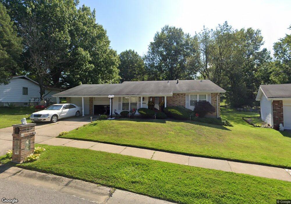
11996 Baresford Dr Florissant, MO 63033
Estimated Value: $195,815 - $215,000
3
Beds
2
Baths
1,284
Sq Ft
$159/Sq Ft
Est. Value
About This Home
This home is located at 11996 Baresford Dr, Florissant, MO 63033 and is currently estimated at $203,704, approximately $158 per square foot. 11996 Baresford Dr is a home located in St. Louis County with nearby schools including Jamestown Elementary School, Central Middle School, and Hazelwood Central High School.
Ownership History
Date
Name
Owned For
Owner Type
Purchase Details
Closed on
Feb 11, 2009
Sold by
Mims Clarence and Mims Clarence
Bought by
Mims Clarence
Current Estimated Value
Home Financials for this Owner
Home Financials are based on the most recent Mortgage that was taken out on this home.
Original Mortgage
$143,901
Outstanding Balance
$90,034
Interest Rate
4.91%
Mortgage Type
FHA
Estimated Equity
$113,670
Purchase Details
Closed on
Dec 28, 2007
Sold by
Moncure Jewell
Bought by
Mims Clarence
Home Financials for this Owner
Home Financials are based on the most recent Mortgage that was taken out on this home.
Original Mortgage
$141,775
Interest Rate
6.23%
Mortgage Type
FHA
Create a Home Valuation Report for This Property
The Home Valuation Report is an in-depth analysis detailing your home's value as well as a comparison with similar homes in the area
Home Values in the Area
Average Home Value in this Area
Purchase History
| Date | Buyer | Sale Price | Title Company |
|---|---|---|---|
| Mims Clarence | -- | None Available | |
| Mims Clarence | $144,000 | None Available |
Source: Public Records
Mortgage History
| Date | Status | Borrower | Loan Amount |
|---|---|---|---|
| Open | Mims Clarence | $143,901 | |
| Closed | Mims Clarence | $141,775 |
Source: Public Records
Tax History Compared to Growth
Tax History
| Year | Tax Paid | Tax Assessment Tax Assessment Total Assessment is a certain percentage of the fair market value that is determined by local assessors to be the total taxable value of land and additions on the property. | Land | Improvement |
|---|---|---|---|---|
| 2025 | $2,756 | $33,310 | $4,200 | $29,110 |
| 2024 | $2,756 | $30,480 | $2,910 | $27,570 |
| 2023 | $2,747 | $30,480 | $2,910 | $27,570 |
| 2022 | $2,401 | $23,680 | $4,850 | $18,830 |
| 2021 | $2,272 | $23,680 | $4,850 | $18,830 |
| 2020 | $2,166 | $21,020 | $4,200 | $16,820 |
| 2019 | $2,149 | $21,020 | $4,200 | $16,820 |
| 2018 | $2,103 | $19,020 | $1,710 | $17,310 |
| 2017 | $2,101 | $19,020 | $1,710 | $17,310 |
| 2016 | $2,098 | $18,680 | $2,470 | $16,210 |
| 2015 | $2,050 | $18,680 | $2,470 | $16,210 |
| 2014 | $1,899 | $17,210 | $3,170 | $14,040 |
Source: Public Records
Map
Nearby Homes
- 12065 El Camara Dr
- 11951 Jerries Ln
- 12095 El Camara Dr
- 12136 La Padera Ln
- 11774 El Somo Ct
- 12292 Jerries Ln
- 6250 Pennyrich Ct
- 5348 Trailoaks Dr
- 5432 Trailbend Dr
- 6530 Farm Pond Ct
- 11760 Sheffield Dr
- 12320 Missile Ln
- 5372 Trailbend Dr
- 5239 Trailoaks Dr
- 12455 Jerries Ln
- 5226 Suntrail Dr
- 6480 Hadden Bay Dr
- 12582 Springtrail Dr
- 6320 Hadden Bay Dr
- 11757 Vizcuya Ct
- 11986 Baresford Dr
- 12006 Baresford Dr
- 11976 Baresford Dr
- 11977 Baresford Dr
- 12026 Baresford Dr
- 12007 Baresford Dr
- 11966 Baresford Dr
- 12027 Baresford Dr
- 12036 Baresford Dr
- 11928 Red Lion Dr
- 12004 Jamesborough Dr
- 11984 Jamesborough Dr
- 11929 Red Lion Dr
- 12014 Jamesborough Dr
- 12037 Baresford Dr
- 11956 Baresford Dr
- 12024 Jamesborough Dr
- 12046 Baresford Dr
- 11938 Red Lion Dr
- 12047 Baresford Dr