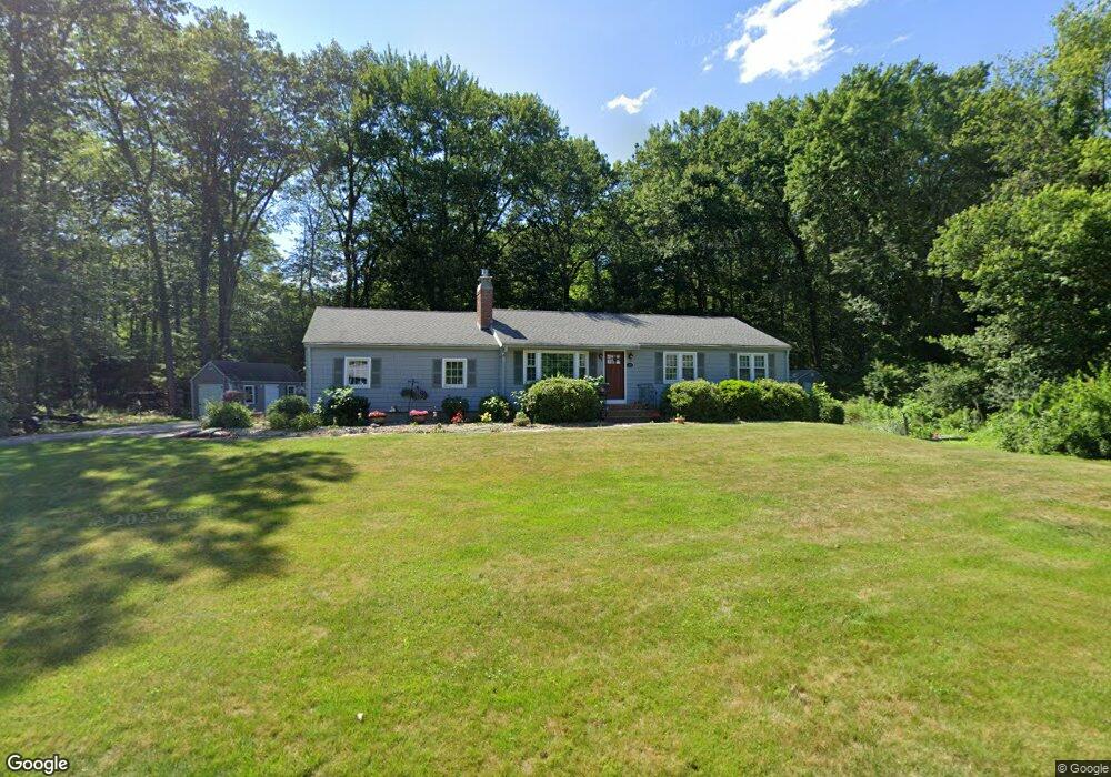
12 Amble Rd Chelmsford, MA 01824
Hitchinpost NeighborhoodEstimated Value: $706,000 - $808,000
2
Beds
1
Bath
780
Sq Ft
$945/Sq Ft
Est. Value
About This Home
This home is located at 12 Amble Rd, Chelmsford, MA 01824 and is currently estimated at $736,937, approximately $944 per square foot. 12 Amble Rd is a home located in Middlesex County with nearby schools including Parker Middle School, Byam Elementary School, and Chelmsford High School.
Ownership History
Date
Name
Owned For
Owner Type
Purchase Details
Closed on
Oct 15, 2018
Sold by
Bailey Jason and Jordan-Bailey Teresa L
Bought by
Jordan-Bailey Teresa L
Current Estimated Value
Home Financials for this Owner
Home Financials are based on the most recent Mortgage that was taken out on this home.
Original Mortgage
$392,000
Outstanding Balance
$333,512
Interest Rate
3.99%
Mortgage Type
Adjustable Rate Mortgage/ARM
Estimated Equity
$403,425
Purchase Details
Closed on
Nov 20, 2015
Sold by
Profio Richard and Profio Carol M
Bought by
Bailey Jason and Jordan-Bailey Teresa L
Home Financials for this Owner
Home Financials are based on the most recent Mortgage that was taken out on this home.
Original Mortgage
$324,000
Interest Rate
3%
Mortgage Type
Adjustable Rate Mortgage/ARM
Create a Home Valuation Report for This Property
The Home Valuation Report is an in-depth analysis detailing your home's value as well as a comparison with similar homes in the area
Home Values in the Area
Average Home Value in this Area
Purchase History
We collect this data history from publicly available records. To have your information removed, we recommend requesting removal directly through your county’s website.
| Date | Buyer | Sale Price | Title Company |
|---|---|---|---|
| Jordan-Bailey Teresa L | -- | -- | |
| Jordan-Bailey Teresa | -- | -- | |
| Bailey Jason | $405,000 | -- |
Source: Public Records
Mortgage History
We collect this data history from publicly available records. To have your information removed, we recommend requesting removal directly through your county’s website.
| Date | Status | Borrower | Loan Amount |
|---|---|---|---|
| Open | Jordan-Bailey Teresa | $392,000 | |
| Closed | Jordan-Bailey Teresa L | $392,000 | |
| Previous Owner | Bailey Jason | $324,000 |
Source: Public Records
Tax History
| Year | Tax Paid | Tax Assessment Tax Assessment Total Assessment is a certain percentage of the fair market value that is determined by local assessors to be the total taxable value of land and additions on the property. | Land | Improvement |
|---|---|---|---|---|
| 2025 | $8,599 | $618,600 | $355,100 | $263,500 |
| 2024 | $8,552 | $627,900 | $355,100 | $272,800 |
| 2023 | $8,287 | $576,700 | $369,100 | $207,600 |
| 2022 | $8,103 | $513,800 | $316,800 | $197,000 |
| 2021 | $7,365 | $467,900 | $290,600 | $177,300 |
| 2020 | $7,445 | $452,600 | $257,600 | $195,000 |
| 2019 | $7,302 | $446,600 | $261,900 | $184,700 |
| 2018 | $7,213 | $401,600 | $228,000 | $173,600 |
| 2017 | $6,729 | $375,500 | $213,600 | $161,900 |
| 2016 | $6,255 | $346,900 | $203,400 | $143,500 |
| 2015 | $6,107 | $326,600 | $184,800 | $141,800 |
| 2014 | $5,929 | $312,400 | $176,500 | $135,900 |
Source: Public Records
Map
Nearby Homes
- 8 Galloway Rd
- 360 Littleton Rd Unit E5
- 360 Littleton Rd Unit C7
- 189 Littleton Rd Unit 19
- 189 Littleton Rd Unit 62
- 181 Littleton Rd Unit 123
- 2 Bartlett Rd
- 10 Baldwin Rd
- 69 Byam Rd
- 14 Walnut Rd
- 3 Linden St
- 6 Barn Ln
- 40 Grandview Rd
- 3 Archambault Way
- 19 Dalton Rd
- 2 Charlemont Ct
- 9 Acton Rd Unit 6
- 9 Acton Rd Unit 8
- 1 Hemlock Dr
- 123 Plain Rd
Your Personal Tour Guide
Ask me questions while you tour the home.