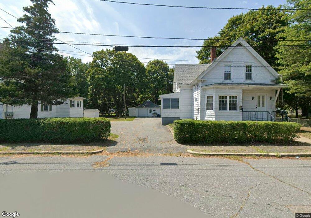
12 Arthur St Taunton, MA 02780
Prospect Hill NeighborhoodEstimated Value: $325,955 - $469,000
3
Beds
2
Baths
1,419
Sq Ft
$280/Sq Ft
Est. Value
About This Home
This home is located at 12 Arthur St, Taunton, MA 02780 and is currently estimated at $397,478, approximately $280 per square foot. 12 Arthur St is a home located in Bristol County with nearby schools including Benjamin Friedman Middle School, Taunton High School, and Our Lady of Lourdes School.
Ownership History
Date
Name
Owned For
Owner Type
Purchase Details
Closed on
Sep 30, 2025
Sold by
Leclair Eugene R Est and Leclair
Bought by
Khoury Adam and Brown Abigael
Current Estimated Value
Home Financials for this Owner
Home Financials are based on the most recent Mortgage that was taken out on this home.
Original Mortgage
$388,000
Outstanding Balance
$387,655
Interest Rate
6.58%
Mortgage Type
New Conventional
Estimated Equity
$9,823
Purchase Details
Closed on
Nov 4, 1987
Sold by
Leclair Colette Y
Bought by
Leclair Eugene R
Create a Home Valuation Report for This Property
The Home Valuation Report is an in-depth analysis detailing your home's value as well as a comparison with similar homes in the area
Home Values in the Area
Average Home Value in this Area
Purchase History
| Date | Buyer | Sale Price | Title Company |
|---|---|---|---|
| Khoury Adam | $400,000 | -- | |
| Leclair Eugene R | $68,000 | -- |
Source: Public Records
Mortgage History
| Date | Status | Borrower | Loan Amount |
|---|---|---|---|
| Open | Khoury Adam | $388,000 | |
| Previous Owner | Leclair Eugene R | $189,000 | |
| Closed | Leclair Eugene R | $0 |
Source: Public Records
Tax History Compared to Growth
Tax History
| Year | Tax Paid | Tax Assessment Tax Assessment Total Assessment is a certain percentage of the fair market value that is determined by local assessors to be the total taxable value of land and additions on the property. | Land | Improvement |
|---|---|---|---|---|
| 2025 | $4,341 | $396,800 | $106,100 | $290,700 |
| 2024 | $3,912 | $349,600 | $106,100 | $243,500 |
| 2023 | $0 | $299,400 | $88,400 | $211,000 |
| 2022 | $0 | $263,000 | $80,300 | $182,700 |
| 2021 | $0 | $243,300 | $80,300 | $163,000 |
| 2020 | $0 | $224,900 | $80,300 | $144,600 |
| 2019 | $0 | $209,100 | $84,300 | $124,800 |
| 2018 | $0 | $211,100 | $88,900 | $122,200 |
| 2017 | $0 | $186,800 | $79,100 | $107,700 |
| 2016 | -- | $181,900 | $76,800 | $105,100 |
| 2015 | $3,020 | $185,900 | $76,800 | $109,100 |
| 2014 | $3,020 | $183,900 | $76,800 | $107,100 |
Source: Public Records
Map
Nearby Homes
- 22 Garfield St
- 3 4th Ave
- 3 4th Ave Unit 1
- 3 4th Ave Unit 2
- 43 Avon St
- 9 Abbey Ln
- 12 Lisa Dr
- 12 Oxford St
- 17 Lisa Dr
- 27 Monroe St
- 28 Madison St
- 0 Whittenton St
- 9 Jefferson St
- 0 Montclair Ave Unit 72130752
- 68 Sabbatia Ln
- 22 John St Unit 22
- 6 Makepeace Ave
- 8 Spinnaker Ln Unit B
- 86 Lakeview Ave
- 37 Winter St