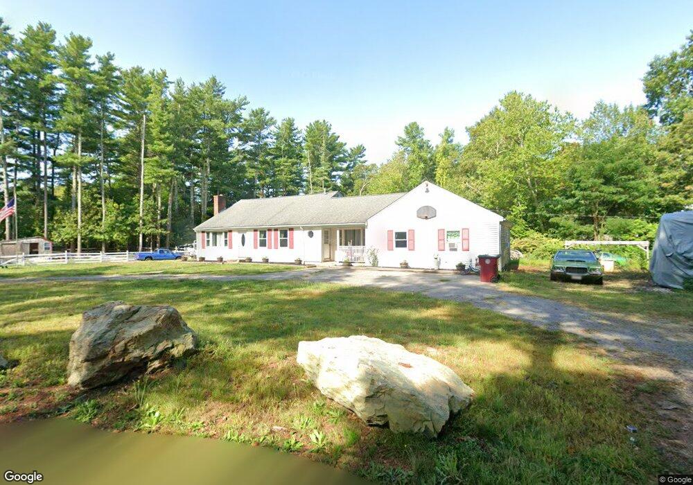
12 Atwood Ave Middleboro, MA 02346
Estimated Value: $541,000 - $695,000
2
Beds
2
Baths
2,416
Sq Ft
$251/Sq Ft
Est. Value
About This Home
This home is located at 12 Atwood Ave, Middleboro, MA 02346 and is currently estimated at $607,584, approximately $251 per square foot. 12 Atwood Ave is a home located in Plymouth County with nearby schools including Mary K. Goode Elementary School and Samuel Fuller School.
Ownership History
Date
Name
Owned For
Owner Type
Purchase Details
Closed on
Apr 1, 2002
Sold by
Singley Paul E
Bought by
Benoit Richard M
Current Estimated Value
Home Financials for this Owner
Home Financials are based on the most recent Mortgage that was taken out on this home.
Original Mortgage
$218,500
Interest Rate
6.88%
Mortgage Type
Purchase Money Mortgage
Create a Home Valuation Report for This Property
The Home Valuation Report is an in-depth analysis detailing your home's value as well as a comparison with similar homes in the area
Home Values in the Area
Average Home Value in this Area
Purchase History
| Date | Buyer | Sale Price | Title Company |
|---|---|---|---|
| Benoit Richard M | $230,000 | -- |
Source: Public Records
Mortgage History
| Date | Status | Borrower | Loan Amount |
|---|---|---|---|
| Open | Benoit Richard M | $238,000 | |
| Closed | Benoit Richard M | $218,500 | |
| Previous Owner | Benoit Richard M | $10,000 |
Source: Public Records
Tax History Compared to Growth
Tax History
| Year | Tax Paid | Tax Assessment Tax Assessment Total Assessment is a certain percentage of the fair market value that is determined by local assessors to be the total taxable value of land and additions on the property. | Land | Improvement |
|---|---|---|---|---|
| 2025 | $6,925 | $516,400 | $168,100 | $348,300 |
| 2024 | $6,908 | $510,200 | $160,300 | $349,900 |
| 2023 | $6,445 | $452,600 | $160,300 | $292,300 |
| 2022 | $6,047 | $393,200 | $139,400 | $253,800 |
| 2021 | $6,119 | $376,100 | $122,300 | $253,800 |
| 2020 | $5,915 | $372,500 | $122,300 | $250,200 |
| 2019 | $5,574 | $360,100 | $122,300 | $237,800 |
| 2018 | $4,501 | $288,500 | $116,100 | $172,400 |
| 2017 | $4,297 | $272,500 | $112,000 | $160,500 |
| 2016 | $4,095 | $257,200 | $103,100 | $154,100 |
| 2015 | $3,681 | $233,300 | $103,100 | $130,200 |
Source: Public Records
Map
Nearby Homes
- 9 Terrace Way
- 236 Thomas St
- 140 Tispaquin St
- 4 Bella Path
- 112 Rocky Meadow St
- 184 Rocky Meadow St
- 39 Faye Ave
- Lot1 Elk Run Dr
- 6 Rocky Meadow St
- 74 Wall St
- 759 Plymouth St
- 58 Chadderton Way
- 52 Saddleworth Way
- 322 Purchase St
- 44 Lake Shore Dr
- 306 Wood St
- 37 Katrina Rd
- 6 Bryant Cir
- 124 Ashley Ln Unit 12-4
- 14 Pineridge Way Unit 14