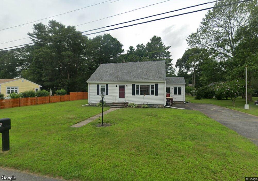
12 Birch St Acushnet, MA 02743
Sherwood Forest NeighborhoodEstimated Value: $413,000 - $448,000
--
Bed
1
Bath
1,290
Sq Ft
$338/Sq Ft
Est. Value
About This Home
This home is located at 12 Birch St, Acushnet, MA 02743 and is currently estimated at $435,463, approximately $337 per square foot. 12 Birch St is a home located in Bristol County with nearby schools including Acushnet Elementary School, Albert F Ford Middle School, and Alma del Mar Charter School.
Ownership History
Date
Name
Owned For
Owner Type
Purchase Details
Closed on
Nov 14, 2024
Sold by
Vasconcellos Tammy and Caton Mark
Bought by
Caton Mark
Current Estimated Value
Home Financials for this Owner
Home Financials are based on the most recent Mortgage that was taken out on this home.
Original Mortgage
$295,000
Outstanding Balance
$292,063
Interest Rate
6.12%
Mortgage Type
New Conventional
Estimated Equity
$143,400
Create a Home Valuation Report for This Property
The Home Valuation Report is an in-depth analysis detailing your home's value as well as a comparison with similar homes in the area
Home Values in the Area
Average Home Value in this Area
Purchase History
| Date | Buyer | Sale Price | Title Company |
|---|---|---|---|
| Caton Mark | -- | Equity National Title | |
| Caton Mark | -- | Equity National Title |
Source: Public Records
Mortgage History
| Date | Status | Borrower | Loan Amount |
|---|---|---|---|
| Open | Caton Mark | $295,000 | |
| Closed | Caton Mark | $295,000 |
Source: Public Records
Tax History Compared to Growth
Tax History
| Year | Tax Paid | Tax Assessment Tax Assessment Total Assessment is a certain percentage of the fair market value that is determined by local assessors to be the total taxable value of land and additions on the property. | Land | Improvement |
|---|---|---|---|---|
| 2025 | $42 | $390,400 | $141,100 | $249,300 |
| 2024 | $4,036 | $353,700 | $133,700 | $220,000 |
| 2023 | $4,048 | $337,300 | $121,300 | $216,000 |
| 2022 | $3,985 | $300,300 | $113,900 | $186,400 |
| 2021 | $3,724 | $269,300 | $113,900 | $155,400 |
| 2020 | $3,649 | $261,800 | $106,400 | $155,400 |
| 2019 | $3,464 | $244,300 | $101,500 | $142,800 |
| 2018 | $3,360 | $233,000 | $101,500 | $131,500 |
| 2017 | $3,249 | $225,000 | $101,500 | $123,500 |
| 2016 | $3,269 | $225,000 | $101,500 | $123,500 |
| 2015 | $3,012 | $210,900 | $101,500 | $109,400 |
Source: Public Records
Map
Nearby Homes
- 26 Rounseville St
- 1045 Forbes St
- ES Acushnet Ave
- 1269 Bartlett St
- 13 Fairway Dr
- 5 Fairway Dr
- 2981 Acushnet Ave
- 847 Terry Ln
- 1044 Phillips Rd Unit 20
- 1044 Phillips Rd Unit 24
- 850 Terry Ln
- 1023 Bowles St
- 957 Glen St
- 7 Morses Ln
- 700 Pine Hill Dr
- 1044 Victoria St Unit B-29
- 16 Morses Ln
- 67 Morses Ln
- 1350 Phillips Rd
- 1214 Church St