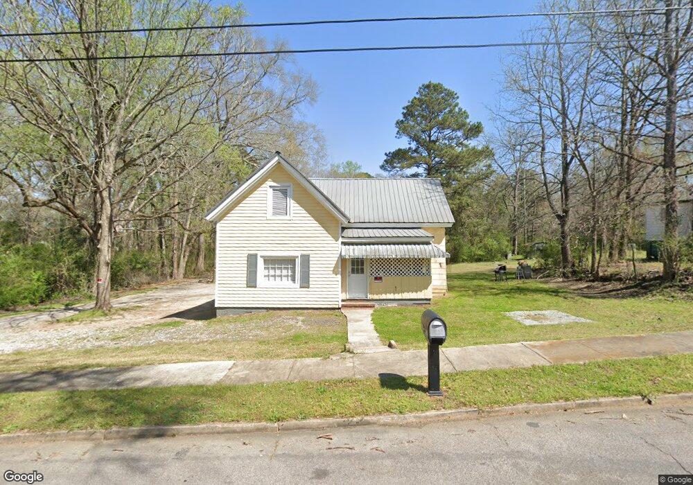
12 Cary St Lagrange, GA 30241
Estimated Value: $57,000 - $190,000
3
Beds
1
Bath
1,202
Sq Ft
$92/Sq Ft
Est. Value
About This Home
This home is located at 12 Cary St, Lagrange, GA 30241 and is currently estimated at $110,351, approximately $91 per square foot. 12 Cary St is a home located in Troup County with nearby schools including Franklin Forest Elementary School, Hollis Hand Elementary School, and Ethel W. Kight Elementary School.
Ownership History
Date
Name
Owned For
Owner Type
Purchase Details
Closed on
May 14, 2021
Sold by
Cavender Steve Estate
Bought by
Gomez Raul
Current Estimated Value
Home Financials for this Owner
Home Financials are based on the most recent Mortgage that was taken out on this home.
Original Mortgage
$25,000
Outstanding Balance
$1,454
Interest Rate
3%
Mortgage Type
New Conventional
Estimated Equity
$108,897
Purchase Details
Closed on
Dec 19, 1991
Sold by
Jackie Cavender
Bought by
Cavender Steve
Purchase Details
Closed on
Nov 6, 1990
Sold by
Cornelius Herndon
Bought by
Jackie Cavender
Purchase Details
Closed on
Dec 2, 1982
Bought by
Cornelius Herndon
Purchase Details
Closed on
May 2, 1979
Purchase Details
Closed on
Oct 1, 1964
Sold by
Dunson Mills
Create a Home Valuation Report for This Property
The Home Valuation Report is an in-depth analysis detailing your home's value as well as a comparison with similar homes in the area
Home Values in the Area
Average Home Value in this Area
Purchase History
| Date | Buyer | Sale Price | Title Company |
|---|---|---|---|
| Gomez Raul | $30,000 | -- | |
| Cavender Steve | -- | -- | |
| Jackie Cavender | $14,000 | -- | |
| Cornelius Herndon | $11,000 | -- | |
| -- | -- | -- | |
| -- | -- | -- |
Source: Public Records
Mortgage History
| Date | Status | Borrower | Loan Amount |
|---|---|---|---|
| Open | Gomez Raul | $25,000 |
Source: Public Records
Tax History Compared to Growth
Tax History
| Year | Tax Paid | Tax Assessment Tax Assessment Total Assessment is a certain percentage of the fair market value that is determined by local assessors to be the total taxable value of land and additions on the property. | Land | Improvement |
|---|---|---|---|---|
| 2024 | $408 | $16,944 | $5,480 | $11,464 |
| 2023 | $416 | $17,236 | $5,480 | $11,756 |
| 2022 | $279 | $16,596 | $5,480 | $11,116 |
| 2021 | $342 | $11,344 | $2,920 | $8,424 |
| 2020 | $342 | $11,344 | $2,920 | $8,424 |
| 2019 | $322 | $10,668 | $2,320 | $8,348 |
| 2018 | $318 | $10,532 | $2,184 | $8,348 |
| 2017 | $318 | $10,532 | $2,184 | $8,348 |
| 2016 | $317 | $10,498 | $2,184 | $8,314 |
| 2015 | $317 | $10,508 | $2,194 | $8,314 |
| 2014 | $318 | $10,508 | $2,194 | $8,314 |
| 2013 | -- | $9,007 | $2,000 | $7,007 |
Source: Public Records
Map
Nearby Homes
- 15 Fulton St
- 5 Curran Ave
- Coleman Plan at Crossvine Village
- 0 Mill Creek Pkwy Unit PHASE 5 10313564
- Beckman Plan at Crossvine Village
- 0 Mill Creek Pkwy Unit PHASE 4 10313585
- Fairfield Plan at Crossvine Village
- Broadmoor Plan at Crossvine Village
- Dover Plan at Crossvine Village
- 130 Clara Jean Ct
- 0 N Barnard Ave
- 128 Shenandoah Ln Unit A67
- 113 Lenox Cir
- 124 Shenandoah Ln
- 227 River Meadow Dr Unit H14
- 231 River Meadow Dr
- 412 Sweetwood Ct Unit A36
- 719 Windstream Dr Unit B61
- 719 Windstream Dr
- 721 Windstream Dr Unit B62