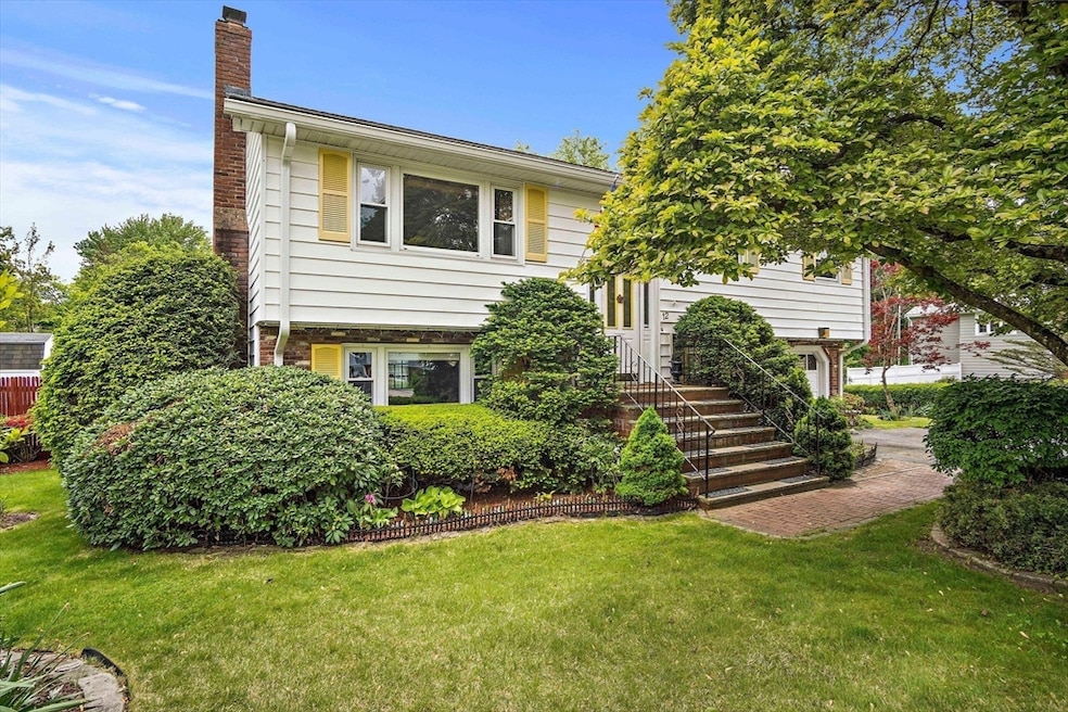
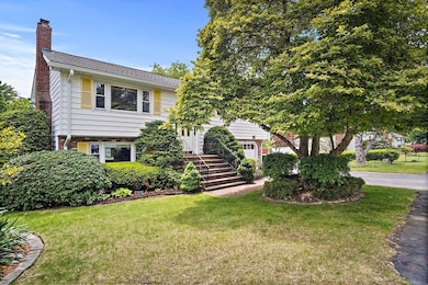
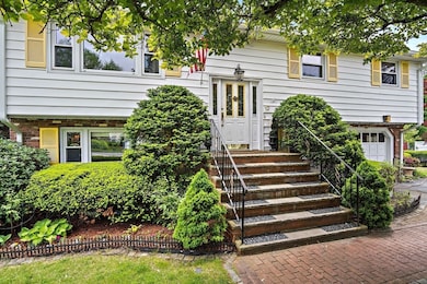

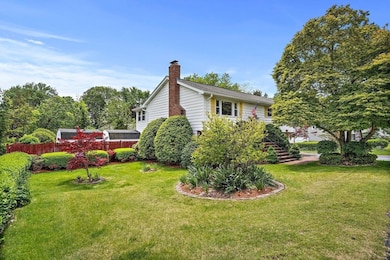
12 Cassidy Dr Woburn, MA 01801
Cummingsville NeighborhoodEstimated payment $4,945/month
Highlights
- Golf Course Community
- In Ground Pool
- Family Room with Fireplace
- Medical Services
- Landscaped Professionally
- Wooded Lot
About This Home
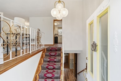
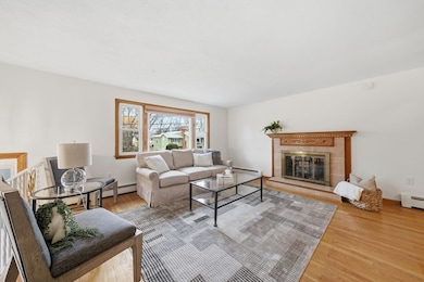
A superb location and lush landscaping highlight this split level home with massive inground pool. Beautiful hardwood floors span the main living level which features a lovely fireplace as a focal point of the open concept living room and dining area. The kitchen offers plenty of prep space, stainless steel appliances and views of the backyard. A sunroom off the rear offers tons of natural light and peaceful views. Find 3 nicely sized bedrooms and a full bath with tons of warm character. The lower level features a large family room with fireplace and walk out access to the yard making it convenient for entertaining. This level also offers a laundry room, home office and full bath. An attached one car garage completes this level and is ideal for storage. Enjoy the home's ultra flat lot which sits conveniently near four corners, Woburn center and major highways. Walk to new park being constructed now, Just a short 10 minute walk.
Home Details
Home Type
- Single Family
Est. Annual Taxes
- $5,850
Year Built
- Built in 1968
Lot Details
- 0.41 Acre Lot
- Fenced Yard
- Landscaped Professionally
- Level Lot
- Wooded Lot
Parking
- 1 Car Attached Garage
- Tuck Under Parking
- Parking Storage or Cabinetry
- Garage Door Opener
- Driveway
- Open Parking
- Off-Street Parking
Home Design
- Split Level Home
- Brick Exterior Construction
- Frame Construction
- Shingle Roof
- Concrete Perimeter Foundation
Interior Spaces
- Central Vacuum
- Decorative Lighting
- Family Room with Fireplace
- 2 Fireplaces
- Living Room with Fireplace
- Sun or Florida Room
Kitchen
- Range
- Dishwasher
Flooring
- Wood
- Carpet
- Ceramic Tile
Bedrooms and Bathrooms
- 4 Bedrooms
- Primary Bedroom on Main
- 2 Full Bathrooms
Laundry
- Laundry Room
- Dryer
- Washer
Finished Basement
- Walk-Out Basement
- Basement Fills Entire Space Under The House
- Interior Basement Entry
- Garage Access
- Block Basement Construction
- Laundry in Basement
Outdoor Features
- In Ground Pool
- Patio
- Outdoor Storage
Location
- Property is near schools
Utilities
- No Cooling
- Heating System Uses Natural Gas
- Baseboard Heating
- Gas Water Heater
Listing and Financial Details
- Assessor Parcel Number 907795
Community Details
Overview
- No Home Owners Association
Amenities
- Medical Services
- Shops
Recreation
- Golf Course Community
- Community Pool
Map
Home Values in the Area
Average Home Value in this Area
Tax History
| Year | Tax Paid | Tax Assessment Tax Assessment Total Assessment is a certain percentage of the fair market value that is determined by local assessors to be the total taxable value of land and additions on the property. | Land | Improvement |
|---|---|---|---|---|
| 2025 | $6,348 | $743,300 | $371,800 | $371,500 |
| 2024 | $5,850 | $725,800 | $354,300 | $371,500 |
| 2023 | $5,680 | $652,900 | $322,000 | $330,900 |
| 2022 | $5,483 | $587,000 | $280,500 | $306,500 |
| 2021 | $5,248 | $562,500 | $267,300 | $295,200 |
| 2020 | $5,140 | $551,500 | $267,300 | $284,200 |
| 2019 | $4,867 | $512,300 | $254,700 | $257,600 |
| 2018 | $4,656 | $470,800 | $234,000 | $236,800 |
| 2017 | $4,477 | $450,400 | $223,000 | $227,400 |
| 2016 | $4,282 | $426,100 | $208,700 | $217,400 |
| 2015 | $4,205 | $413,500 | $195,200 | $218,300 |
| 2014 | $4,047 | $387,600 | $195,200 | $192,400 |
Property History
| Date | Event | Price | List to Sale | Price per Sq Ft |
|---|---|---|---|---|
| 11/30/2025 11/30/25 | Pending | -- | -- | -- |
| 11/14/2025 11/14/25 | For Sale | $849,900 | -- | $392 / Sq Ft |
Purchase History
| Date | Type | Sale Price | Title Company |
|---|---|---|---|
| Quit Claim Deed | -- | None Available | |
| Quit Claim Deed | -- | None Available | |
| Quit Claim Deed | -- | None Available | |
| Quit Claim Deed | -- | None Available | |
| Quit Claim Deed | -- | None Available | |
| Quit Claim Deed | -- | None Available | |
| Quit Claim Deed | -- | None Available | |
| Quit Claim Deed | -- | None Available |
Source: MLS Property Information Network (MLS PIN)
MLS Number: 73455035
APN: WOBU-000041-000009-000042
Disclaimer: Certain information contained herein is derived from information provided by parties other than Homes.com. All information provided is deemed reliable, but is not guaranteed to be accurate and should be independently verified.
![]() The property listing data and information, or the Images, set forth herein were provided to MLS Property Information Network, Inc. from third party sources, including sellers, lessors and public records, and were compiled by MLS Property Information Network, Inc. The property listing data and information, and the Images, are for the personal, non-commercial use of consumers having a good faith interest in purchasing or leasing listed properties of the type displayed to them and may not be used for any purpose other than to identify prospective properties which such consumers may have a good faith interest in purchasing or leasing. MLS Property Information Network, Inc. and its subscribers disclaim any and all representations and warranties as to the accuracy of the property listing data and information, or as to the accuracy of any of the Images, set forth herein.
The property listing data and information, or the Images, set forth herein were provided to MLS Property Information Network, Inc. from third party sources, including sellers, lessors and public records, and were compiled by MLS Property Information Network, Inc. The property listing data and information, and the Images, are for the personal, non-commercial use of consumers having a good faith interest in purchasing or leasing listed properties of the type displayed to them and may not be used for any purpose other than to identify prospective properties which such consumers may have a good faith interest in purchasing or leasing. MLS Property Information Network, Inc. and its subscribers disclaim any and all representations and warranties as to the accuracy of the property listing data and information, or as to the accuracy of any of the Images, set forth herein.
- 7 Locust St
- 18 Winn Valley Dr
- 17 Wright St
- 4 Ardmore Ave
- 29 Overlook Ave
- 26 Flagg St
- 68 Hammond Place Unit 68
- 18 Hamilton Rd
- 36 Cambridge Rd Unit 40
- 37 1/2 Chestnut St
- 82 Lowell St
- 19 Hammond Place Unit 19
- 18 Beacon St Unit 18
- 3 Hart St
- 166 Place Ln Unit 166
- 168 Place Ln
- 21 Franklin St
- 52 Pleasant St
- 31 Arlington Rd Unit 1-6
- 27 Arlington Rd Unit 1-6
