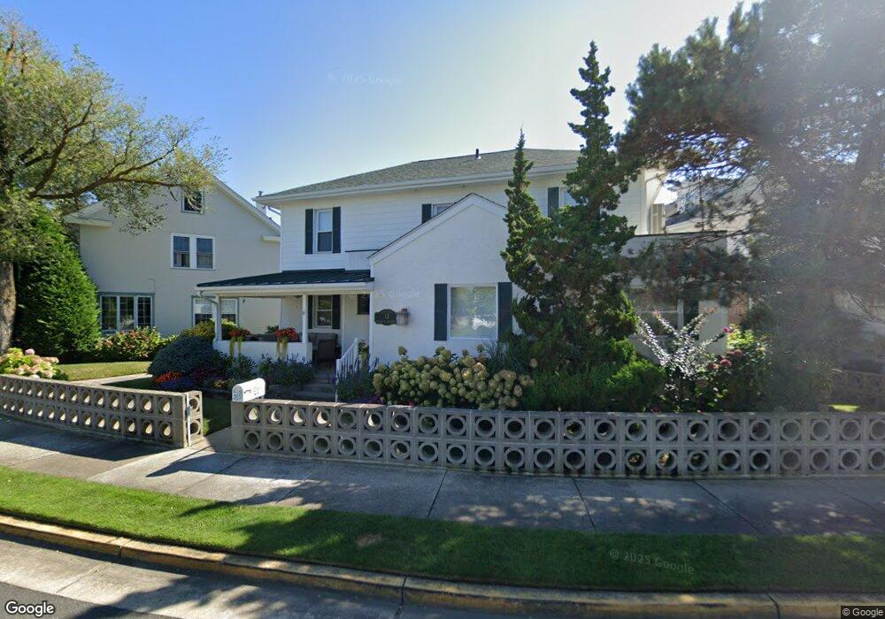
12 Circle Dr Margate City, NJ 08402
Estimated Value: $1,211,423 - $1,493,000
4
Beds
3
Baths
2,024
Sq Ft
$650/Sq Ft
Est. Value
About This Home
This home is located at 12 Circle Dr, Margate City, NJ 08402 and is currently estimated at $1,315,606, approximately $650 per square foot. 12 Circle Dr is a home located in Atlantic County with nearby schools including William H. Ross III Intermediate School, Eugene A. Tighe Middle School, and Blessed Sacrament Regional School.
Ownership History
Date
Name
Owned For
Owner Type
Purchase Details
Closed on
May 23, 2008
Sold by
Phillips Marlene D and Phillips William
Bought by
Goldstein James B and Goldstein Diana B
Current Estimated Value
Home Financials for this Owner
Home Financials are based on the most recent Mortgage that was taken out on this home.
Original Mortgage
$417,000
Outstanding Balance
$267,244
Interest Rate
6.11%
Mortgage Type
Purchase Money Mortgage
Estimated Equity
$1,048,362
Purchase Details
Closed on
Dec 9, 2002
Sold by
Phillips Marlene D and Dicicco Marlene
Bought by
Phillips William and Phillips Marlene D
Purchase Details
Closed on
May 19, 1997
Sold by
Pollock Seymour and Pollock Mary Ann
Bought by
Dicicco Marlene
Create a Home Valuation Report for This Property
The Home Valuation Report is an in-depth analysis detailing your home's value as well as a comparison with similar homes in the area
Home Values in the Area
Average Home Value in this Area
Purchase History
| Date | Buyer | Sale Price | Title Company |
|---|---|---|---|
| Goldstein James B | $725,000 | Commonwealth Land Title Insu | |
| Phillips William | -- | -- | |
| Dicicco Marlene | $180,000 | The Title Company |
Source: Public Records
Mortgage History
| Date | Status | Borrower | Loan Amount |
|---|---|---|---|
| Open | Goldstein James B | $417,000 |
Source: Public Records
Tax History Compared to Growth
Tax History
| Year | Tax Paid | Tax Assessment Tax Assessment Total Assessment is a certain percentage of the fair market value that is determined by local assessors to be the total taxable value of land and additions on the property. | Land | Improvement |
|---|---|---|---|---|
| 2025 | $8,101 | $474,300 | $321,300 | $153,000 |
| 2024 | $8,101 | $474,300 | $321,300 | $153,000 |
| 2023 | $7,484 | $474,300 | $321,300 | $153,000 |
| 2022 | $7,484 | $474,300 | $321,300 | $153,000 |
| 2021 | $7,380 | $474,300 | $321,300 | $153,000 |
| 2020 | $7,342 | $474,300 | $321,300 | $153,000 |
| 2019 | $7,314 | $474,300 | $321,300 | $153,000 |
| 2018 | $7,413 | $474,300 | $321,300 | $153,000 |
| 2017 | $7,423 | $474,300 | $321,300 | $153,000 |
| 2016 | $7,171 | $474,300 | $321,300 | $153,000 |
| 2015 | $7,058 | $474,300 | $321,300 | $153,000 |
| 2014 | $6,925 | $474,300 | $321,300 | $153,000 |
Source: Public Records
Map
Nearby Homes
- 29 East Dr
- 7311 Monmouth Ave
- 7407 Ventnor Ave
- 119 N Brunswick Ave
- 7403 Monmouth Ave
- 1 N Clarendon Ave
- 26 N Delavan Ave
- 217 N Argyle Ave
- 203 N Melbourne Ave
- 132 N Lafayette Ave
- 107 N Douglas Ave
- 2 S Melbourne Ave
- 31 N Essex Ave
- 1 S Douglas Ave Unit 1
- 1 S Douglas Ave
- 7800 Ventnor Ave Unit C
- 7800 Ventnor Ave Unit A
- 7800 Ventnor Ave Unit D
- 7800 Ventnor Ave Unit B
- 221 N Delavan Ave