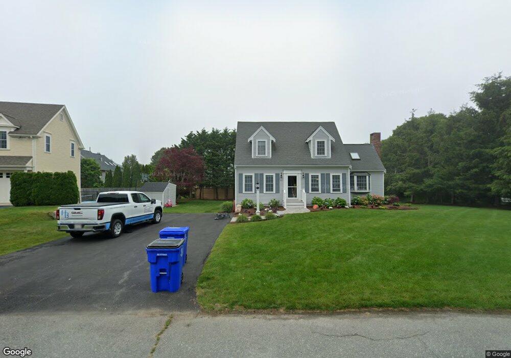
12 Cleveland Cir Bourne, MA 2532
Estimated Value: $563,000 - $626,000
3
Beds
2
Baths
1,486
Sq Ft
$409/Sq Ft
Est. Value
About This Home
This home is located at 12 Cleveland Cir, Bourne, MA 2532 and is currently estimated at $607,394, approximately $408 per square foot. 12 Cleveland Cir is a home located in Barnstable County with nearby schools including Bourne High School, St Margaret Regional School, and Cadence Academy Preschool - Bourne.
Ownership History
Date
Name
Owned For
Owner Type
Purchase Details
Closed on
Oct 22, 2020
Sold by
Cahill William W
Bought by
Maffioli Brian C and Maffioli Lisa
Current Estimated Value
Home Financials for this Owner
Home Financials are based on the most recent Mortgage that was taken out on this home.
Original Mortgage
$267,500
Outstanding Balance
$237,389
Interest Rate
2.9%
Mortgage Type
New Conventional
Estimated Equity
$370,005
Purchase Details
Closed on
Feb 20, 2003
Sold by
Cahill Veronica
Bought by
Cahill William W
Home Financials for this Owner
Home Financials are based on the most recent Mortgage that was taken out on this home.
Original Mortgage
$140,000
Interest Rate
5.98%
Mortgage Type
Purchase Money Mortgage
Create a Home Valuation Report for This Property
The Home Valuation Report is an in-depth analysis detailing your home's value as well as a comparison with similar homes in the area
Home Values in the Area
Average Home Value in this Area
Purchase History
| Date | Buyer | Sale Price | Title Company |
|---|---|---|---|
| Maffioli Brian C | $367,000 | None Available | |
| Maffioli Brian C | $367,000 | None Available | |
| Cahill William W | $245,000 | -- | |
| Cahill William W | $245,000 | -- |
Source: Public Records
Mortgage History
| Date | Status | Borrower | Loan Amount |
|---|---|---|---|
| Open | Maffioli Brian C | $267,500 | |
| Closed | Maffioli Brian C | $267,500 | |
| Previous Owner | Cahill William W | $140,000 | |
| Previous Owner | Cahill William W | $20,240 |
Source: Public Records
Tax History Compared to Growth
Tax History
| Year | Tax Paid | Tax Assessment Tax Assessment Total Assessment is a certain percentage of the fair market value that is determined by local assessors to be the total taxable value of land and additions on the property. | Land | Improvement |
|---|---|---|---|---|
| 2025 | $4,433 | $567,600 | $235,100 | $332,500 |
| 2024 | $4,335 | $540,500 | $223,900 | $316,600 |
| 2023 | $3,706 | $420,700 | $198,200 | $222,500 |
| 2022 | $3,553 | $352,100 | $175,400 | $176,700 |
| 2021 | $3,315 | $307,800 | $159,600 | $148,200 |
| 2020 | $3,213 | $299,200 | $158,100 | $141,100 |
| 2019 | $3,247 | $308,900 | $175,600 | $133,300 |
| 2018 | $3,034 | $287,900 | $167,300 | $120,600 |
| 2017 | $2,952 | $286,600 | $165,700 | $120,900 |
| 2016 | $2,494 | $245,500 | $149,200 | $96,300 |
| 2015 | $2,250 | $223,400 | $127,100 | $96,300 |
Source: Public Records
Map
Nearby Homes
- 203 County Rd
- 18 Carlton Rd
- 16 Washington Ave
- 151 - 153 Main St
- 13 Laurel Hill Ct
- 34 Washington Ave
- 46 Holt Rd
- 46 Holt Rd Unit A
- 18 Douglas Ave
- 12 Beachwood Rd
- 5 Sea Knoll Ct
- 14 Great Rock Rd
- 44 Cotuit Rd
- 26 Carnoustie Rd
- 56 Rip Van Winkle Way
- 22 Bay View Ave
- 1 Pine Tree Dr
- 12 Turnberry Rd Unit 12
- 34 Turnberry Rd
- 12 Cleveland Cir
- 10 Cleveland Cir
- 10 Cleveland Cir
- 44 Sea Breeze Dr
- 44 Seabreeze Dr
- 6 Cleveland Cir
- 6 Cleveland Cir
- 9 Stackpole Cir
- 46 Sea Breeze Dr
- 46 Seabreeze Dr
- 42 Sea Breeze Dr
- 5 Stackpole Cir
- 11 Cleveland Cir
- 1 Mashnee Rd
- 1 Mashnee Rd
- 125 Presidents Rd
- 45 Sea Breeze Dr
- 45 Seabreeze Dr
- 40 Sea Breeze Dr
- 5 Mashnee Rd