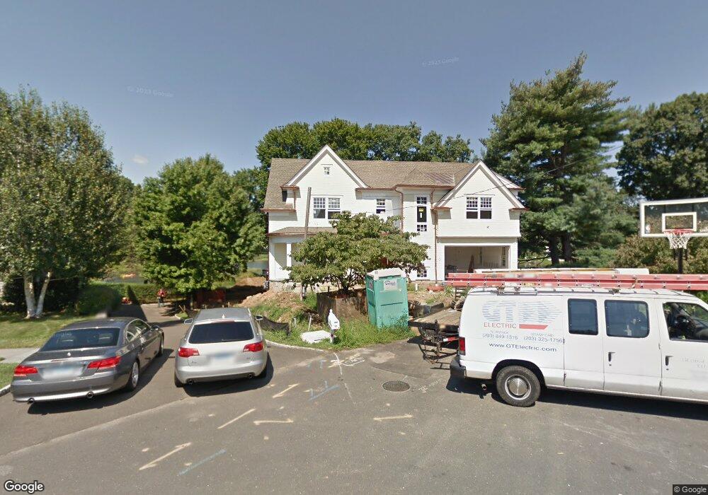
12 Cove Ridge Ln Old Greenwich, CT 06870
Old Greenwich NeighborhoodEstimated Value: $5,067,460 - $5,725,000
5
Beds
6
Baths
4,541
Sq Ft
$1,199/Sq Ft
Est. Value
About This Home
This home is located at 12 Cove Ridge Ln, Old Greenwich, CT 06870 and is currently estimated at $5,444,820, approximately $1,199 per square foot. 12 Cove Ridge Ln is a home located in Fairfield County with nearby schools including Old Greenwich School, Eastern Middle School, and Greenwich High School.
Ownership History
Date
Name
Owned For
Owner Type
Purchase Details
Closed on
Dec 3, 2010
Sold by
Gorman Thomas C and Gorman Karen G
Bought by
Onn Anthony Nichola and Rahmani Valerie
Current Estimated Value
Create a Home Valuation Report for This Property
The Home Valuation Report is an in-depth analysis detailing your home's value as well as a comparison with similar homes in the area
Home Values in the Area
Average Home Value in this Area
Purchase History
| Date | Buyer | Sale Price | Title Company |
|---|---|---|---|
| Onn Anthony Nichola | $2,350,000 | -- |
Source: Public Records
Mortgage History
| Date | Status | Borrower | Loan Amount |
|---|---|---|---|
| Open | Onn Anthony Nichola | $2,500,000 |
Source: Public Records
Tax History Compared to Growth
Tax History
| Year | Tax Paid | Tax Assessment Tax Assessment Total Assessment is a certain percentage of the fair market value that is determined by local assessors to be the total taxable value of land and additions on the property. | Land | Improvement |
|---|---|---|---|---|
| 2025 | $29,231 | $2,365,160 | $1,336,300 | $1,028,860 |
| 2024 | $28,231 | $2,365,160 | $1,336,300 | $1,028,860 |
| 2023 | $27,414 | $2,355,990 | $1,336,300 | $1,019,690 |
| 2022 | $27,165 | $2,355,990 | $1,336,300 | $1,019,690 |
| 2021 | $26,535 | $2,203,880 | $1,127,840 | $1,076,040 |
| 2020 | $26,491 | $2,203,880 | $1,127,840 | $1,076,040 |
| 2019 | $26,755 | $2,203,880 | $1,127,840 | $1,076,040 |
| 2018 | $26,160 | $2,203,880 | $1,127,840 | $1,076,040 |
| 2017 | $26,488 | $2,203,880 | $1,127,840 | $1,076,040 |
| 2016 | $26,070 | $2,203,880 | $1,127,840 | $1,076,040 |
| 2015 | $28,809 | $2,428,510 | $1,539,370 | $889,140 |
| 2014 | $28,231 | $2,428,510 | $1,539,370 | $889,140 |
Source: Public Records
Map
Nearby Homes
- 8 Cove Ridge Ln
- 14 Cove Ridge Ln
- 7 Cove Ridge Ln
- 23 Hendrie Drive Extension
- 4 Cove Ridge Ln
- 11 Cove Ridge Ln
- 18 Hendrie Dr
- 3 Cove Ridge Ln
- 21 Shoalpoint Ln
- 17 Hendrie Dr
- 21 Shoal Point Ln
- 21 Hendrie Dr
- 22 Shoal Point Ln
- 13 Hendrie Dr
- 22 Shoalpoint Ln
- 19 Shoalpoint Ln
- 19 Shoal Point Ln
- 24 Hendrie Drive Extension
- 28 Hendrie Dr
- 24 Hendrie Dr