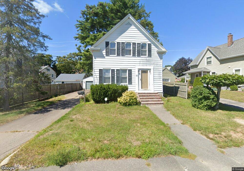
12 Danforth St Taunton, MA 02780
Whittenton Junction NeighborhoodEstimated Value: $337,000 - $459,000
3
Beds
2
Baths
1,251
Sq Ft
$327/Sq Ft
Est. Value
About This Home
This home is located at 12 Danforth St, Taunton, MA 02780 and is currently estimated at $409,351, approximately $327 per square foot. 12 Danforth St is a home located in Bristol County with nearby schools including H. H. Galligan School, Benjamin Friedman Middle School, and Taunton High School.
Ownership History
Date
Name
Owned For
Owner Type
Purchase Details
Closed on
Jun 14, 2010
Sold by
Hsbc Mortgage Corp
Bought by
Rullo Jeffrey M
Current Estimated Value
Home Financials for this Owner
Home Financials are based on the most recent Mortgage that was taken out on this home.
Original Mortgage
$134,900
Outstanding Balance
$91,029
Interest Rate
5.11%
Mortgage Type
Purchase Money Mortgage
Estimated Equity
$318,322
Purchase Details
Closed on
Mar 30, 2009
Sold by
Hsbc Mortgage Svcs and Cushing Randolph Willia
Bought by
Hsbc Mortgage Svcs Inc
Purchase Details
Closed on
Jul 18, 2005
Sold by
Moulding Robin M and Oreilly Robin M
Bought by
Cushing Randolph Willia
Home Financials for this Owner
Home Financials are based on the most recent Mortgage that was taken out on this home.
Original Mortgage
$215,200
Interest Rate
5.67%
Mortgage Type
Purchase Money Mortgage
Purchase Details
Closed on
Oct 1, 2003
Sold by
Wheeler Jeffrey E and Wheeler Audra A
Bought by
Oreilly Mark F and Oreilly Robin M
Home Financials for this Owner
Home Financials are based on the most recent Mortgage that was taken out on this home.
Original Mortgage
$195,200
Interest Rate
6.25%
Mortgage Type
Purchase Money Mortgage
Purchase Details
Closed on
Jun 16, 2000
Sold by
3C Rt and Cutcliffe Paul C
Bought by
Wheeler Jeffrey E and Wheeler Audra A
Home Financials for this Owner
Home Financials are based on the most recent Mortgage that was taken out on this home.
Original Mortgage
$137,750
Interest Rate
8.24%
Mortgage Type
Purchase Money Mortgage
Purchase Details
Closed on
Sep 17, 1999
Sold by
Barger Michael A
Bought by
3 C Rt and Cutcliffe Paul C
Purchase Details
Closed on
Jul 21, 1994
Sold by
Spaulding John L and Lorraine Sanford E
Bought by
Barger Michael A
Home Financials for this Owner
Home Financials are based on the most recent Mortgage that was taken out on this home.
Original Mortgage
$75,100
Interest Rate
8.19%
Mortgage Type
Purchase Money Mortgage
Create a Home Valuation Report for This Property
The Home Valuation Report is an in-depth analysis detailing your home's value as well as a comparison with similar homes in the area
Home Values in the Area
Average Home Value in this Area
Purchase History
| Date | Buyer | Sale Price | Title Company |
|---|---|---|---|
| Rullo Jeffrey M | $129,900 | -- | |
| Hsbc Mortgage Svcs Inc | $98,000 | -- | |
| Cushing Randolph Willia | $269,000 | -- | |
| Oreilly Mark F | $244,000 | -- | |
| Wheeler Jeffrey E | $145,000 | -- | |
| 3 C Rt | $91,500 | -- | |
| Barger Michael A | $83,500 | -- |
Source: Public Records
Mortgage History
| Date | Status | Borrower | Loan Amount |
|---|---|---|---|
| Open | Rullo Jeffrey M | $134,900 | |
| Closed | Barger Michael A | $10,000 | |
| Previous Owner | Cushing Randolph Willia | $215,200 | |
| Previous Owner | Oreilly Mark F | $195,200 | |
| Previous Owner | Barger Michael A | $137,750 | |
| Previous Owner | Barger Michael A | $75,100 |
Source: Public Records
Tax History
| Year | Tax Paid | Tax Assessment Tax Assessment Total Assessment is a certain percentage of the fair market value that is determined by local assessors to be the total taxable value of land and additions on the property. | Land | Improvement |
|---|---|---|---|---|
| 2025 | $3,942 | $360,300 | $97,200 | $263,100 |
| 2024 | $3,506 | $313,300 | $97,200 | $216,100 |
| 2023 | $3,441 | $285,600 | $97,200 | $188,400 |
| 2022 | $3,291 | $249,700 | $81,000 | $168,700 |
| 2021 | $3,161 | $222,600 | $73,700 | $148,900 |
| 2020 | $3,033 | $204,100 | $73,700 | $130,400 |
| 2019 | $2,906 | $184,400 | $73,700 | $110,700 |
| 2018 | $2,817 | $179,200 | $73,600 | $105,600 |
| 2017 | $2,532 | $161,200 | $69,800 | $91,400 |
| 2016 | $2,455 | $156,600 | $67,800 | $88,800 |
| 2015 | $2,426 | $161,600 | $68,200 | $93,400 |
| 2014 | $2,345 | $160,500 | $65,800 | $94,700 |
Source: Public Records
Map
Nearby Homes
- 99 Tremont St
- 108 Tremont St
- 26 Fremont St
- 19 Crapo St
- 41 Fremont St
- 60 Danforth St
- 23 Granite St
- 40 Filipe Way Unit B
- 17 Anawan St
- 68 Fremont St
- 110 Eldridge St Unit B
- 4 Pine St
- 193 Tremont St Unit 85
- 214 Eldridge St
- 92 Broadway
- 161 Cohannet St
- 399 Danforth St
- 111 Dunbar St
- 99 Winthrop St
- 2 Norton Ave
- 10 Danforth St
- 14 Danforth St
- 7 Maxwell St
- 16 Danforth St
- 9 Maxwell St
- 11 Danforth St
- 15 Danforth St
- 18 Danforth St
- 6 Maxwell St
- 8 Maxwell St
- 8 Maxwell St
- 8 Maxwell St Unit 2
- 8 Maxwell St Unit 1
- 6 Danforth St
- 11 Maxwell St
- 11 Maxwell St Unit 2
- 7 Danforth St
- 17 Danforth St
- 10 Maxwell St
- 20 Danforth St
Your Personal Tour Guide
Ask me questions while you tour the home.