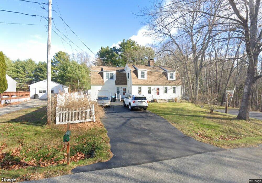
12 Deer Ln Windham, ME 04062
Estimated Value: $478,000 - $566,000
4
Beds
3
Baths
2,200
Sq Ft
$235/Sq Ft
Est. Value
About This Home
This home is located at 12 Deer Ln, Windham, ME 04062 and is currently estimated at $517,525, approximately $235 per square foot. 12 Deer Ln is a home located in Cumberland County with nearby schools including Manchester School, Windham Primary School, and Windham Middle School.
Ownership History
Date
Name
Owned For
Owner Type
Purchase Details
Closed on
Apr 24, 2020
Sold by
Egan Burns
Bought by
Burns and Egan Kathie
Current Estimated Value
Purchase Details
Closed on
Dec 13, 2013
Sold by
Burns-Egan Kathie A
Bought by
Burns-Egan Kathie A
Home Financials for this Owner
Home Financials are based on the most recent Mortgage that was taken out on this home.
Original Mortgage
$135,300
Interest Rate
4.14%
Mortgage Type
Unknown
Create a Home Valuation Report for This Property
The Home Valuation Report is an in-depth analysis detailing your home's value as well as a comparison with similar homes in the area
Home Values in the Area
Average Home Value in this Area
Purchase History
| Date | Buyer | Sale Price | Title Company |
|---|---|---|---|
| Burns | -- | None Available | |
| Burns-Egan Kathie A | -- | -- |
Source: Public Records
Mortgage History
| Date | Status | Borrower | Loan Amount |
|---|---|---|---|
| Previous Owner | Burns-Egan Kathie A | $135,300 |
Source: Public Records
Tax History
| Year | Tax Paid | Tax Assessment Tax Assessment Total Assessment is a certain percentage of the fair market value that is determined by local assessors to be the total taxable value of land and additions on the property. | Land | Improvement |
|---|---|---|---|---|
| 2025 | $5,883 | $487,800 | $131,500 | $356,300 |
| 2024 | $5,595 | $487,800 | $131,500 | $356,300 |
| 2023 | $5,174 | $462,000 | $122,200 | $339,800 |
| 2022 | $4,588 | $395,200 | $96,700 | $298,500 |
| 2021 | $4,121 | $327,100 | $84,000 | $243,100 |
| 2020 | $4,241 | $282,700 | $73,600 | $209,100 |
| 2019 | $4,139 | $282,700 | $73,600 | $209,100 |
| 2018 | $3,863 | $254,500 | $66,400 | $188,100 |
| 2017 | $3,910 | $238,000 | $59,500 | $178,500 |
| 2016 | $3,702 | $235,800 | $59,500 | $176,300 |
| 2015 | $3,572 | $235,800 | $59,500 | $176,300 |
| 2014 | $3,459 | $235,800 | $59,500 | $176,300 |
| 2013 | $3,407 | $235,800 | $59,500 | $176,300 |
Source: Public Records
Map
Nearby Homes
- 34 Robin Ln
- 75 Tandberg Trail
- 10 Abby Rd
- 0 Turning Leaf Dr Unit 1640377
- 1 Matinicus Way Unit 1
- 5 Sandbar Rd
- 74 Emerson Dr
- 14 Sabbady Point Rd
- 55 Page Rd
- 14 Emerson Dr
- 103 Basin Rd
- 34 Trails End Rd
- 5 Cardinal Ln
- 36 Belvedere Dr
- 404 Pope Rd
- 192 Varney Mill Rd
- 7 Baxter Woods Trail
- 336 Pope Rd Unit 3
- 32 Middle Jam Rd
- 72 Sand Beach Rd
- 8 Deer Ln
- 17 Robin Ln
- 0 Deer Hollow Unit 169813
- 0 Deer Hollow Unit 153169
- 0 Deer Hollow Unit 153175
- 0 Deer Hollow
- 4 Deer Ln
- 24 Northwood Dr
- 23 Robin Ln
- 12 Robin Ln
- 14 Northwood Dr
- 30 Northwood Dr
- 0 Wood
- 10 Trailwoods
- 28 Robin Ln
- 21 Northwood Dr
- 19 Northwood Dr
- 28 Robyn Unit 14
- 34 Northwood Dr
- 29 Northwood Dr
Your Personal Tour Guide
Ask me questions while you tour the home.